Are wetlands deemed to be of international importance under the Ramsar Convention.
This intergovernmental treaty provides a framework for national action and international cooperation for the conservation and wise use of wetlands and their resources
Wetlands and Ramsar Convention
Wetlands are unique areas where water either covers the soil or is present at or near the surface of the soil throughout the year or during various periods, including the growing season. This persistent water presence significantly influences soil characteristics and the types of plant and animal communities that thrive in these environments. Wetlands support both aquatic and terrestrial species, with water conditions favoring the growth of specially adapted plants, known as hydrophytes, and promoting the development of characteristic wetland soils.
Functions of Wetlands:
Flood Control: Wetlands absorb and slow down floodwaters, reducing the impact of floods.
Sediment and Erosion Control: They trap sediments and mitigate soil erosion.
Nutrient Recycling: Wetlands assist in recycling nutrients, which improves water quality.
Water Purification: They filter pollutants and purify water.
Flood Mitigation: Wetlands act as buffers, alleviating the effects of floods.
Groundwater Recharging: They contribute to the replenishment of groundwater supplies.
Resource Provision: Wetlands supply drinking water, fish, fodder, fuel, and more.
Climate Stability: They play a role in regulating climate.
Maintenance of Streamflow: Wetlands help in maintaining a steady streamflow.
Shoreline Protection: They protect shorelines from erosion.
Sustainable Tourism and Recreation: Wetlands are valuable for sustainable tourism, recreation, and cultural heritage.
The Ramsar Convention: Ramsar wetland Sites Of Himachal
The Ramsar Convention, signed on 2 February 1971, is an international treaty dedicated to the conservation and sustainable use of wetlands. It recognizes the crucial ecological functions of wetlands and their economic, cultural, scientific, and recreational value.
The Convention was implemented in India on 1 February 1982.
On 1 February 2019, the Sundarbans wetland site in West Bengal was added to the Ramsar list.
In January 2020, India included 10 additional wetlands in the Ramsar Convention’s protected sites:
Nandur Madhameshwar (Maharashtra)
Keshopur-Miani, Beas Conservation Reserve, and Nangal (Punjab)
Among the 37 Ramsar sites in India, Himachal Pradesh has 3 Ramsar wetland sites:
Pong Dam Lake
Chandratal
Renuka
Ramsar Wetlands in Himachal Pradesh
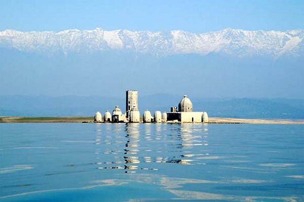
Pong Dam Lake (Kangra)
Pong Dam Lake, Himachal pradesh Ramsar wetland Sites Of HimachalMaharana Pratap Sagar, also known as Pong Reservoir or Pong Dam Lake is a large reservoir in Fatehpur, Jawali and Dehra tehsil of Kangra district of the state of Himachal Pradesh in India. It was created in 1975, by building the highest earthfill dam in India on the Beas River in the wetland zone of the Siwalik Hills.
Date of Declaration: 19 August 2002
Area: 307.29 sq. km
Pong Dam Wetland: A Comprehensive Overview
Introduction: Pong Dam Wetland, also known as Pong Reservoir, is a significant Ramsar site located in Himachal Pradesh, India. It serves as a critical transitory resting spot for migratory birds traveling from the Trans-Himalayan region during the winter months when other wetlands in Europe, North, and Central Asia are frozen. This wetland supports a diverse range of avian species from October to March, offering a vital refuge in more temperate conditions.
Water Body Size: Varies from 125 square kilometers at the minimum water level (1280 feet) to 220 square kilometers at the maximum water level (1390 feet). The drawdown area is about 80 square kilometers.
Coordinates: Latitude 31° 49′ to 32° 14′ N and Longitude 75° 53′ to 76° 17′ E.
Barrage Information: Below the Pong Dam, the Sathana Barrage was constructed in 1985-86. The Sahanahar Canal originates from this barrage, extending approximately 4 kilometers. The barrage itself forms a shallow water body of about 3 square kilometers.
Climate:
Seasonal Patterns: The region experiences a sub-tropical climate.
Summer: Mid-March to mid-July, with temperatures reaching up to 47°C.
Monsoon: Early July to mid-September, characterized by heavy, continuous rainfall.
Winter: Early December to mid-March, with temperatures dropping to as low as 3.5°C.
Geology:
Geomorphology: The wetland is situated in an inter-mountain valley filled with fluvial deposits. Fluvial terraces are prominent, with sediments ranging from boulders to sand grains. The area features a clear distinction between the northern and southern physiographical and fluvial characteristics. The northern side has more stable streams, while the southern side contains ephemeral streams called “choes.” The soil is primarily alluvial and sandy loam.
Flora and Fauna:
Vegetation:
Forests: Sparse on the right bank of the Beas; more extensive on the left bank from Dehra to Terrace, including scrub forests.
Trees: Include Acacia, Jamun, Shisham, Mango, Mulberry, Ficus, Kachnar, Amla, and Prunus. Various shrubs, grasses, and climbers are also present.
Aquatic Vegetation: Submerged vegetation exists but is limited due to seasonal water level fluctuations.
Wildlife:
Mammals: Nilgai, Sambhar, Barking Deer, Wild Boar, Common Monkey, Jackal, Leopard, Jungle Cat, Mongoose, Pangolin, Bats, and Snakes.
Birds: Over 220 species, including migratory and resident birds such as Black-headed Gulls, Brahminy Ducks, Bar-headed Geese, Shovelers, Plovers, Grebes, Cormorants, Darters, Herons, Moorhens, Egrets, Storks, Ruddy Shelducks, Pintails, Coots, Pochards, and Mallards.
Fish: Approximately 27 species from 5 families, including Mahaseer, Katla, Minor Carps, Rohu, and Singhara.
Conservation Status:
Recognition: The Pong Wetland was designated as a Ramsar site in 2002, marking it as a globally significant wetland under the Ramsar Convention for its ecological importance and biodiversity.
Pong Dam Wetland plays a crucial role in supporting a wide array of wildlife and maintaining ecological balance. Its status as a Ramsar site underscores its importance in global wetland conservation efforts.
1. What is the primary ecological significance of Pong Dam Wetland?
a) It serves as a breeding ground for fish.
b) It is a major wintering site for migratory birds.
c) It is a major irrigation source for agriculture.
d) It supports a large population of amphibians.
Answer: b) It is a major wintering site for migratory birds.
2. Which mountain range supplies water to Pong Dam Wetland?
a) Himalayas
b) Western Ghats
c) Aravalli Range
d) Dhauladhar Mountains
Answer: d) Dhauladhar Mountains
3. When was Pong Dam Wetland identified under the Conservation and Management of Wetlands programme?
a) 1990
b) 1994
c) 1998
d) 2000
Answer: b) 1994
4. What is the total catchment area of Pong Dam Wetland?
a) 8,500 square kilometers
b) 10,000 square kilometers
c) 12,562 square kilometers
d) 15,000 square kilometers
Answer: c) 12,562 square kilometers
5. During which months does Pong Dam Wetland typically experience its monsoon season?
a) March to May
b) June to August
c) July to September
d) October to December
Answer: c) July to September
6. Which of the following species is NOT commonly found in Pong Dam Wetland?
a) Brahminy Duck
b) Black-headed Gull
c) Greater Flamingo
d) Bar-headed Goose
Answer: c) Greater Flamingo
7. What is the maximum recorded temperature in Pong Dam Wetland during the summer season?
a) 35°C
b) 40°C
c) 47°C
d) 50°C
Answer: c) 47°C
8. What type of vegetation is found in the Pong Dam Wetland area?
a) Dense evergreen forests
b) Tropical rainforest
c) Sparse scrub forests and submerged aquatic vegetation
d) Desert plants
Answer: c) Sparse scrub forests and submerged aquatic vegetation
9. What year did Pong Dam Wetland become a Ramsar site?
a) 1998
b) 2000
c) 2002
d) 2005
Answer: c) 2002
10. How many fish species have been recorded in Pong Dam Wetland?
a) 20
b) 25
c) 27
d) 30
Answer: c) 27
These questions cover various aspects of Pong Dam Wetland, including its ecological significance, geographical features, and species diversity.
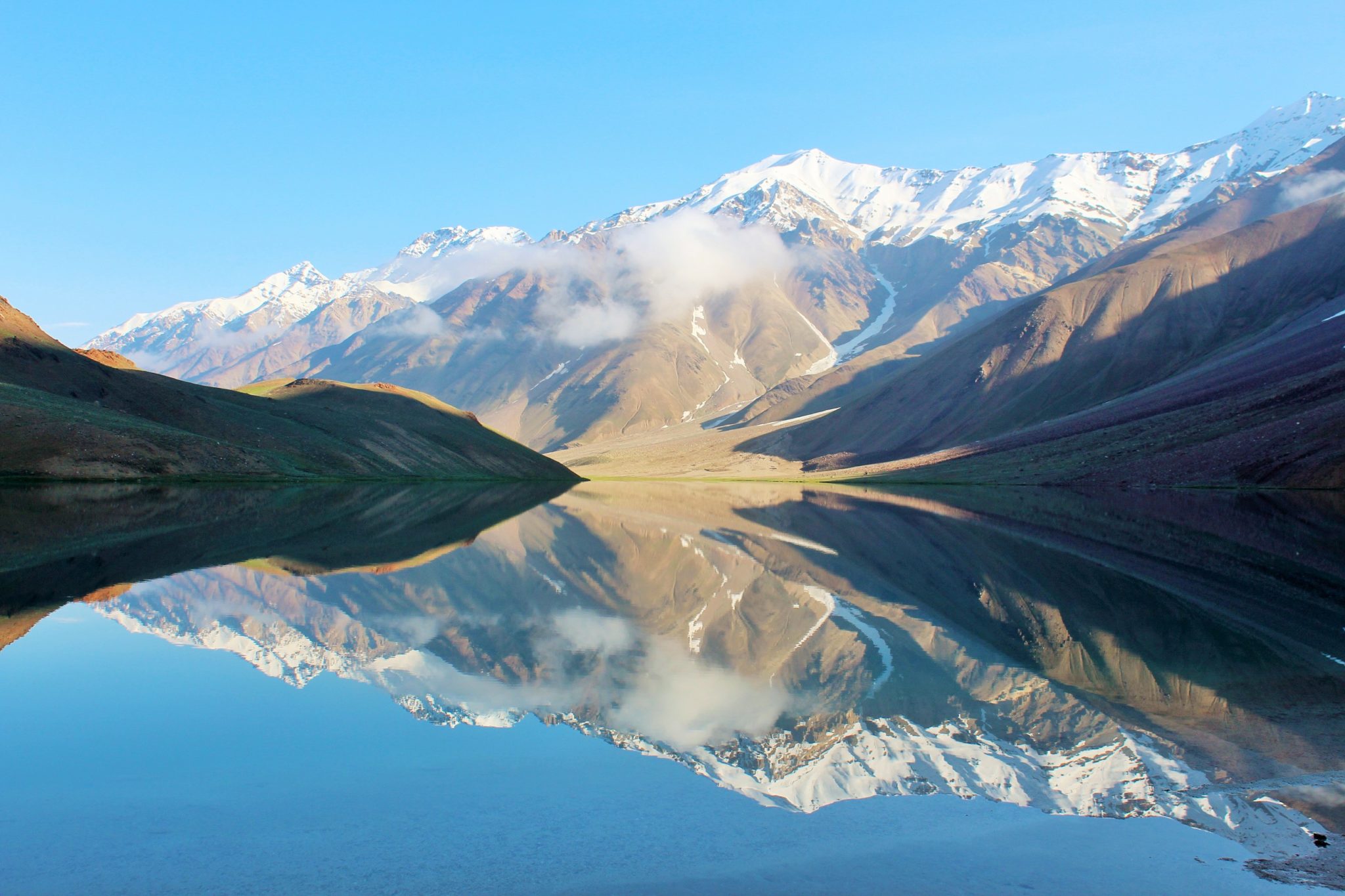
2. Chandertal Wetland (Lahaul-Spiti)
Date of Declaration: 8 November 2005
Area: 38.56 sq. km
Chandertal, a high-altitude wetland situated in the cold desert of the Lahual & Spiti district in Himachal Pradesh, India, lies at an elevation of 4,337 meters above sea level. The wetland is part of the Chandertal Wildlife Sanctuary, which spans 38.56 square kilometers (3,856 hectares). The protected area, including an Eco-Sensitive Zone, extends to 61.50 square kilometers (6,150 hectares). It is located at Latitude 31°28’30” N and Longitude 77°37′ E.
The Chandertal catchment area consists of meadows, rugged rocks, snow, and scree, and is situated in the rain-shadow region of the Himalayas. Monsoon rains are minimal, reaching the valley only as misty drizzles. Precipitation occurs primarily as snowfall, with temperatures plunging to as low as -40°C during winter. The wetland’s soil is glacial and not fully matured. The catchment area, dominated by the snow-covered Kunzam Range, is relatively free from human activity. Approximately 65% of this area is degraded due to glacial action, while 35% is used for seasonal grazing. Given its unique features and ecological importance, Chandertal was designated as a Ramsar Site in 2005.
Climate
The climate of Chandertal is characterized by oxygen deficiency, low atmospheric pressure, intense radiation, extreme cold, and aridity. The average snowfall is 75 cm, and winters are notably harsh with temperatures dropping to -40°C, making it one of the coldest regions in India.
Social and Cultural Values
Chandertal holds various social and cultural values, including its role in fisheries production, forestry, religious significance, and archaeological interest. Despite the lack of permanent human settlement within the catchment area, temporary shelters are erected by migratory grazers from July to September. There are no commercial units or agricultural activities in the vicinity, as the area is devoid of vegetation and human settlement.
Flora and Fauna
The Chandertal wetland and its catchment fall within the Alpine zone, where tree growth is absent and herbaceous flora is predominant. Notable plant species include Potentilla, Ranunculus, Aquilegia, Primula, Aconitum, Aster, Astragalus, Bistorta affinis, Delphinium, Geranium, Oxyria, Polygonum, Rosularia, Stellaria, and Thymus. These plants belong to families such as Ranunculaceae, Poaceae, Asteraceae, Polygonaceae, Rosaceae, Gentianaceae, Geraniaceae, Caryophyllaceae, and Lamiaceae. Common grasses include Poa and Agropyron, known for their high nutritive value.
The fauna of Chandertal includes a range of species adapted to its harsh environment. Mammals such as the Marmot (Marmota bobak), Snow Leopard (Panthera uncia), Red Fox (Vulpes vulpes), Wild Chukar (Alectoris chukar), Himalayan Ibex (Capra ibex), Blue Sheep (Pseudois nayaur), and Snow Cock (Tetraogallus spp.) are present. Bird species include the Black-winged Stilt (Himantopus himantopus), Brahminy Duck (Tadorna ferruginea), and Golden Eagle (Aquila chrysaetos).
What is the elevation of Chandertal wetland?
A) 3,337 meters above sea level
B) 4,337 meters above sea level
C) 5,337 meters above sea level
D) 6,337 meters above sea level
Answer: B) 4,337 meters above sea level
Which mountain range forms the catchment area of Chandertal wetland?
A) Himalayas
B) Kunzam Range
C) Karakoram Range
D) Western Ghats
Answer: B) Kunzam Range
In which year was Chandertal designated as a Ramsar Site?
A) 2000
B) 2005
C) 2010
D) 2015
Answer: B) 2005
Which of the following species is NOT mentioned as being found in Chandertal?
A) Marmot (Marmota bobak)
B) Snow Leopard (Panthera uncia)
C) Golden Eagle (Aquila chrysaetos)
D) Bengal Tiger (Panthera tigris tigris)
Answer: D) Bengal Tiger (Panthera tigris tigris)
What is the primary form of precipitation at Chandertal?
A) Rainfall
B) Hail
C) Snowfall
D) Fog
Answer: C) Snowfall
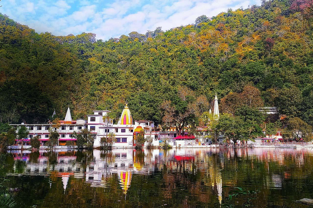
3.Renuka Wetland (Sirmaur)
Date of Declaration: 8 November 2005
Renuka Wetland is situated in the Sirmaur district of Himachal Pradesh, India, at an elevation of 672 meters above sea level. It features an oblong shape, flanked by two parallel steep hills running east-west. The wetland’s geographical coordinates are Latitude 35°58’N to 37°08’N and Longitude 77°26’34″E to 77°28’21″E. Encompassing a total area of 402.80 hectares, the Renuka Lake, the largest natural lake in Himachal Pradesh, is renowned for its picturesque setting and rich biodiversity. It is not only a popular holiday destination but also a revered pilgrimage site.
Renuka Wetland is accessible by road and is located 123 km from Parwanoo, 60 km from Paonta Sahib, and 37 km from Nahan. The lake is shaped like a reclining woman, which aligns with the local legend. According to mythology, Renuka was killed by her son, the legendary sage Parashurama, in compliance with his father’s command. After her death, the lake was formed, surrounded by golden corn fields. Each November, a vibrant fair is held to honor Renuka’s immortality and celebrate her son, featuring colorful festivities and processions with decorated idols.
The wetland is a perennial water body fed by 21 seasonal streams, particularly vigorous during the monsoon season. It is also sustained by internal springs and a subterranean network of channels within the limestone and dolomite formations. Due to its rich biodiversity and unique ecological characteristics, Renuka Wetland was designated as a Ramsar Site in 2005.
Climate
Renuka Wetland experiences a subtropical monsoonic climate. The average annual precipitation ranges from 150 to 199.9 cm, with a maximum average temperature of 30°C. Winters are mild in the low-lying areas, while the higher mountain ranges experience snowfall. Springs are warm and sunny, and the rainy season is marked by high humidity and significant rainfall. Summers can be quite hot, especially during the monsoon months.
Geology
The geological composition of the Renuka Wetland catchment area includes dark carbonaceous shales and slates, interbedded with thin slaty quartzites from the Infra Krol Group. The rocks are often calcareous and consist of quartz, carbonate, sericite, pyrite, and occasionally chlorite. The surrounding formations include green-gray calcareous shale and argillaceous limestone from the Krol A Group, purple-red shales with intercalations of green shales and thin dolomitic cherty limestone from the Krol B Group, and well-bedded grayish-white limestone with shale representing the Krol C Group. These rock formations date back to the Neo-Proterozoic-Proterozoic era. The soil in the region is a heterogeneous mixture of carbonate rocks, sandstones, shales, and siltstones, with a generally thin cover due to weathering and limited conditions.
Flora & Fauna
Renuka Wetland boasts a rich biodiversity, hosting over 440 faunal species ranging from protozoa to mammals. The vegetation in the area includes subtropical forest species such as Chhal, Sain, Bahera, Harar, Kachnar, Tun, Shisham, and Amaltas. A natural Sal forest exists on the northern side of the wetland. Despite the relatively small catchment area of 500 hectares, the wetland supports a diverse range of wildlife, including Ghoral, Kakkar, Chital, Hare, Porcupine, Black Bear, Monkey, and Langur.
The aquatic life in the wetland includes various fish species and tortoises. Additionally, Renuka Wetland is becoming an important habitat for many local and migratory bird species. Resident bird groups found in the area include pheasants, partridges, parrots, jungle fowl, and magpies, among others.
Q.1
Where is Renuka Wetland located? A. Uttarakhand B. Punjab C. Himachal Pradesh D. Jammu & Kashmir Answer: C Explanation: Renuka Wetland is situated in the Sirmaur district of Himachal Pradesh.
Q.2
What is the shape of Renuka Lake? A. Circular B. Oblong C. Square D. Triangular Answer: B Explanation: Renuka Lake is described as oblong in shape.
Q.3
Which of the following is NOT a neighboring location to Renuka Wetland? A. Parwanoo B. Paonta Sahib C. Nahan D. Shimla Answer: D Explanation: Renuka Wetland is 123 km from Parwanoo, 60 km from Paonta Sahib, and 37 km from Nahan, but it is not near Shimla.
Q.4
In which year was Renuka Wetland designated as a Ramsar Site? A. 1995 B. 2000 C. 2005 D. 2010 Answer: C Explanation: Renuka Wetland was declared a Ramsar Site in 2005.
Q.5
What type of climate does Renuka Wetland experience? A. Tropical rainforest B. Subtropical monsoonic C. Desert D. Alpine Answer: B Explanation: The climate of Renuka Wetland is described as subtropical monsoonic.
Q.6
What geological age do the rock formations in the Renuka Wetland area belong to? A. Mesozoic B. Cenozoic C. Neo-Proterozoic-Proterozoic D. Paleozoic Answer: C Explanation: The rock formations in the Renuka Wetland area date back to the Neo-Proterozoic-Proterozoic era.
Q.7
Which of the following species is NOT mentioned as part of Renuka Wetland’s wildlife? A. Ghoral B. Black Bear C. Snow Leopard D. Langur Answer: C Explanation: The wildlife mentioned includes Ghoral, Black Bear, and Langur, but not the Snow Leopard.
Q.8
What is the primary source of water for Renuka Wetland? A. Rainwater B. Seasonal streams C. Underground springs D. River inflows Answer: C Explanation: The primary source of water for Renuka Wetland is internal springs and an underground network of channels.
Q.9
Which trees are found in the subtropical forests around Renuka Wetland? A. Pine and Cedar B. Oak and Maple C. Chhal and Sain D. Teak and Mahogany Answer: C Explanation: The subtropical forests around Renuka Wetland include trees such as Chhal and Sain.
Q.10
What is the average annual precipitation at Renuka Wetland? A. 50-100 cm B. 100-150 cm C. 150-199.9 cm D. 200-250 cm Answer: C Explanation: The average annual precipitation at Renuka Wetland ranges from 150 to 199.9 cm.
Khajjiar Wetland Overview
Location and Description:
Location: North-east of Dalhousie, Chamba district, Himachal Pradesh, India
Altitude: 1900 meters above sea level
Coordinates: Latitude 32°32’N, Longitude 76°4’E
Area: 4500 square meters
Catchment Area: 6 square kilometers
Khajjiar Wetland is nestled within the Ravi basin and is often referred to as the “Mini-Switzerland” due to its picturesque scenery. The wetland is located in a saucer-shaped glade surrounded by deodar forests and is fed by rainwater, snowmelt, and surface runoff.
Climate:
Precipitation: Heavy rains during the monsoon season (peaking at 350 cm in July) and snow during winter, with January experiencing the highest snowfall.
Temperature: Ranges from sub-zero in winter to 32°C in summer.
Wind: Generally 6-11 km/h, occasionally reaching up to 30 km/h.
Geology: Khajjiar is part of the Dhaludhar range of the Western Himalayas, characterized by Silurian rocks such as slates, schist, and conglomerate. The underlying granite, gneiss, and quartzite are part of the Dalhousie Granite formation.
Social & Cultural Significance: The wetland is named after the Khajji Nag Temple, located within the glade. Locals consider it sacred and rely on it for their livelihood through tourism and grazing for livestock. Activities include horse riding for tourists and maintaining local hotels.
Flora and Fauna:
Flora:
Vegetation: Includes Chil Pine (Pinus roxburghii), Ban Oak, Deodar, Fir, and Spruce.
Medicinal Plants: Includes Patish, Barian, Chora, Shafoo, and Ashwagandha.
Weeds: The wetland has become marshy with the presence of Typha, Thalia geniculata, and other weed species due to siltation and biomass accumulation.
Fauna:
Mammals: Leopard, Himalayan Fox, Black Bear, Stripped Hyena, Goral, Barking Deer, Hanuman Langur, Rhesus Monkey, and Flying Squirrel.
Birds: Includes Black Eagle, Cinereous Vulture, Himalayan Griffon, Lammergeier, Himalayan Monal, Kalij Pheasant, Koklass, and numerous species of parakeets, woodpeckers, and warblers.
Khajjiar Wetland is a vital ecological and cultural asset in Himachal Pradesh, offering significant biodiversity and scenic beauty. Its rich flora and fauna, combined with its cultural significance and picturesque landscape, make it an important area for conservation and tourism.
Rewalsar Wetland Overview
Location and Description:
Location: District Mandi, Himachal Pradesh, India
Distance from Mandi: 24 km southwest on the Mandi-Hamirpur highway
Altitude: 1360 meters above mean sea level
Coordinates: Latitude 31°37’30” N, Longitude 76°49′ E
Shape and Size: Square-shaped lake with a shoreline of approximately 735 meters
Catchment Area: 173 hectares
Rewalsar is a small, natural wetland situated in the confluence of the Sikandara-Dhar and Barkot ranges of the sub-mountainous Himalayas. It is renowned for its scenic beauty and sacred significance, particularly for Hindus, Buddhists, and Sikhs, due to its association with serpent worship. The wetland is fed primarily by internal springs.
Climate:
Type: Sub-tropical monsoonic
Average Precipitation: 1690 mm annually
Temperature: Ranges from freezing in winter to 33°C during summer
Seasons: Four distinct seasons—winter (December to February), summer (March to June), rainy (July to September), and autumn (October to November)
Geology: The Rewalsar area features hilly terrain with a catchment composed mainly of Middle Siwalik Group rocks from the Pliocene era. The predominant lithology includes fine-grained, light-colored sandstones interlayered with gray siltstones and shales. The sedimentary rocks are prone to weathering and erosion, leading to a landscape of softer, unstable strata. The depression forming the lake is likely caused by a strike-slip fault running in a NE-SW direction. Clayey soils are common in the area, and the sediments are derived from local metamorphic terrain.
Social & Cultural Values:
Economic Importance: The lake has a perennial outflow that supports irrigation for downstream agriculture, contributing to local productivity. The wetland also provides fuel and fodder for nearby communities.
Religious Significance: Rewalsar is a major pilgrimage site with year-round visitors due to its religious and historical importance.
Flora and Fauna:
Flora:
Vegetation: The surrounding forest consists of chir forest and scrub with subtropical species including khair, shisham, kachnar, and chir.
Macrophytes: The lake is home to genera such as Nymphaea (water lilies), Trapa (water chestnuts), Ceratophyllum (hornworts), and Phragmites (reeds).
Vascular Plants: 262 species belonging to 82 families and 220 genera, with one gymnosperm and the rest angiosperms. Notable species include various monocotyledons.
Phytoplankton: 47 genera, including 11 Myxophyceae, 18 Chlorophyceae, and 18 Bacillariophyceae. Blue-green algae are prevalent.
Fauna:
Mammals: Includes jackals, leopards, snakes, monitor lizards, mongooses, monkeys, porcupines, and barking deer.
Birds: Notable species include the Indian coot, brown coot, white-breasted kingfishers, and Kalij pheasant.
Fish: Rich in fish species such as Channa marulius, C. straitus, C. punctius, Cyprinus carpio, Carassius auratus, Catla catla, Puntius ticto, P. sarana, and Rasbora rasbora.
Rewalsar Wetland is an important ecological and cultural site in Himachal Pradesh, offering a blend of natural beauty, rich biodiversity, and significant cultural heritage.
Questions with Answers
What is the term for wetlands of international importance?
Ramsar wetlands (Correct Answer)
National wetlands
State wetlands
Local wetlands
Which state in India has the most Ramsar sites?
Himachal Pradesh
Uttar Pradesh
Kerala
Rajasthan
How many Ramsar sites are there in Himachal Pradesh?
3 (Correct Answer)
2
4
5
Which of these is a Ramsar site in Himachal Pradesh?
Pong Dam Lake (Correct Answer)
Dal Lake
Wular Lake
Loktak Lake
In which district is Renuka Lake located?
Sirmaur (Correct Answer)
Kangra
Kullu
Chamba
What is the significance of Chandertal Lake as a Ramsar site?
High altitude and unique ecosystem (Correct Answer)
Large size and bird diversity
Historical importance
Religious significance
Which of these is not a Ramsar site but is a wetland of national importance in Himachal Pradesh?
Rewalsar (Correct Answer)
Pong Dam Lake
Renuka Lake
Chandertal Lake
What is the primary role of Ramsar wetlands?
Conservation of biodiversity (Correct Answer)
Water supply for agriculture
Hydropower generation
Recreational activities
Why is Pong Dam Lake considered a Ramsar site?
Rich biodiversity, especially birdlife (Correct Answer)
Its large size
Its historical importance
Its role in irrigation
What is the ecological significance of wetlands?
They regulate water flow and support biodiversity (Correct Answer)