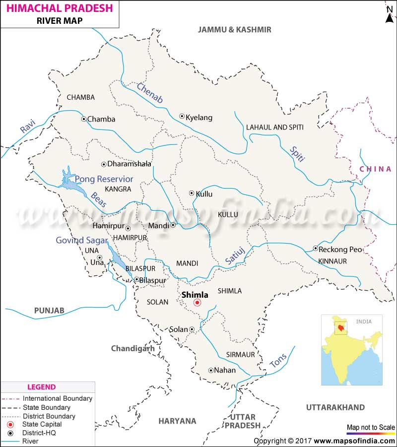
River System of Himachal Pradesh: The Beas, Ravi, and Satluj rivers flow through Himachal Pradesh, vital for agriculture, hydropower, and regional ecosystems.
Rivers of Himachal Pradesh
Satluj River Basin Overview
The Satluj River Basin, a key component of the River System in Himachal Pradesh, stretches approximately 320 kilometers. Originating from the serene Rakas Lake in the Kailash Mountains of Tibet, this river flows through several districts in Himachal Pradesh, significantly influencing the region’s geography and ecology.
The districts traversed by the Satluj River include:
- Lahaul-Spiti
- Kinnaur
- Shimla
- Kullu
- Mandi
- Bilaspur
The Satluj River, with its vital role in the River System in Himachal Pradesh, not only shapes the landscapes but also supports the local communities and ecosystems throughout its journey.
Catchment Area: 20,398 square kilometers (36.6% of Himachal Pradesh’s area)
Hydroelectric Projects:
- Commissioned, Under Construction, & Planned: 142 projects
- Total Installed Capacity: 10,031 MW
- Potential Capacity: 13,332 MW
Main Tributaries:
- Spiti
- Kerang
- Baspa
- Nogli
River Narratives: Satluj
Origin and Name:
- The Satluj River is the largest and fastest river in Himachal Pradesh.
- It originates from the southern slopes of the Kailash Mountains in Tibet, specifically from Rakas Lake.
- In Tibet, it is known as Longcchen Khabab.
- The name “Satluj” is derived from Sanskrit, where Satadru or Satudri means “running in a hundred streams.”
Course:
- The Satluj flows from Tibet into India at Shipkila.
- It cuts across the Great Himalayan Range near Kalpa, Kinnaur.
- The river traverses several districts in Himachal Pradesh including Lahaul and Spiti, Kinnaur, Shimla, Kullu, Mandi, Solan, and Bilaspur.
- It is considered an antecedent river, existing before the Upper Pleistocene uplift of the Himalayas.
Catchment Area and Flow:
- The catchment area, including the Parechu River, is 51,600 square kilometers.
- The river covers approximately 45% of Himachal Pradesh’s total geographical area.
- The annual mean flow of the Satluj is 16,755.33 MCM.
- It flows for around 320 kilometers.
Glaciers and Snowfall:
- The average annual snowfall in the basin is 4,685 mm (based on an 18-year average).
- 85% of the total snowfall occurs between December and March.
- The basin features hilly terrain and unstable geology, making much of the area inaccessible.
- There are about 945 glaciers within the basin, covering 1,217.70 square kilometers.
- The estimated ice reserve within the basin is 94.45 cubic kilometers.
- Most glaciers are located in the northeastern part of the basin.
Major Tributaries of the Satluj River
Spiti River:
- Originates from the Kunzum Range and flows 150 km through Kinnaur district.
- Confluences with Satluj at Khab and continues to Namgia (Khab), about 14 km upstream of Pooh.
- The Spiti River’s catchment area is 10,071 square kilometers.
- Known for heavy winter snowfall, significantly contributing to Satluj’s flow in spring.
- Major tributaries include the Pin River and Lingti River.
- The catchment area upstream of Khab is 10,170 square kilometers, largely devoid of vegetation, leading to significant soil erosion.
- Settlements in the Spiti Valley include Hansi and Dhankar Gompa.
Kerang River:
- A right-bank tributary of the Satluj, originating from glaciers in the permanent snow zone, making it perennial.
- The catchment includes steep mountains, dense forests, and areas under permanent snow.
- Pager Garang is a major tributary of Kerang, joining at its left bank near Lippa.
Baspa River:
- Originates from the Arsomang and Baspa Bamak glaciers and flows 72 km before joining Satluj at Karcham.
- Has a catchment area of 1,102 square kilometers, with 20% covered by glaciers.
- The basin comprises 19 valleys, most covered with thick vegetation.
- Tributary streams often bring sediments, occasionally blocking the river.
Nogli Khad:
- A snow-fed and rain-fed stream that joins Satluj at Nogli.
- Originates as Sageti Gad east of a 5,236 m high peak on Kumashi Kharang Dhar.
- Flows for 38 km with a gradient of 1:9.97 and merges with Satluj at 910 meters near Nogli village.
Religious and Cultural Significance
Tattapani:
- “Tattapani” means “hot water.”
- Known for its hot sulphur springs beside the right riverbank of Satluj, covering over one square kilometer.
- A pilgrimage site with year-round visitors, especially during Lohri (January 26) and Tara Ratri.
- The hot springs are believed to help with arthritis, skin infections, and fatigue.
Kye Monastery:
- Located in Spiti, a key center for Buddhist studies.
- Over 1,000 years old, housing rare Thangka paintings and ancient musical instruments.
Tabo Monastery:
- Referred to as the “Ajanta of the Himalayas.”
- Situated at an altitude of 3,050 meters on the left bank of the Spiti River.
- Founded by Richen Zangpo in the 10th century, declared a UNESCO World Heritage Site.
- Contains rare scriptures and wall paintings, including Thankas and Stucco.
- Nearby is the Giu mummy, a Lama who died in meditation during an avalanche.
Temples of Sangla:
- Includes Nag Mandir and Devi Maa Mandir.
- Known for richly decorated semi-Buddhist architecture, reflecting a Hindu-Buddhist confluence.
- The main idol in Sangla temples is said to have originated from the Dhauladhars.
Ecology and Biodiversity
- The Satluj River Basin is part of the Western Himalaya, known for its rich flora due to diverse topography and climatic conditions.
- The basin’s forests include 24 forest types with a total cover area of 2,550.90 square kilometers.
- The basin is divided into three ecological zones:
- Lower Zone: Bhakhra Dam to Nathpa
- Middle Zone: Nathpa to Khab
- Upper Zone: Khab to Kunzum
- Vegetation types include:
- Lower and upper western Himalayan temperate forests
- Dry temperate coniferous forests
- Sub-alpine forests and scrubs
- Alpine pastures with dwarf Juniper scrub and dry alpine scrub communities
- Neoza Pine (Pinus Gerardiana) is found only in Himachal Pradesh, covering 120.68 square kilometers in the Satluj basin.
- The Oak Scrub forest type is present in Himachal Pradesh, with half its distribution in the Satluj Basin.
- The Satluj Basin hosts 10 protected areas and supports habitats for key wildlife species.
- 368 bird species have been recorded, with 43 species highly dependent on the river.
- 26 species are listed under the “Critical Faunal Species” category, including amphibians, birds, and mammals.
- The Parhio Valley in Pin Valley National Park is renowned for its fossil richness, with fossils dating back over a billion years.
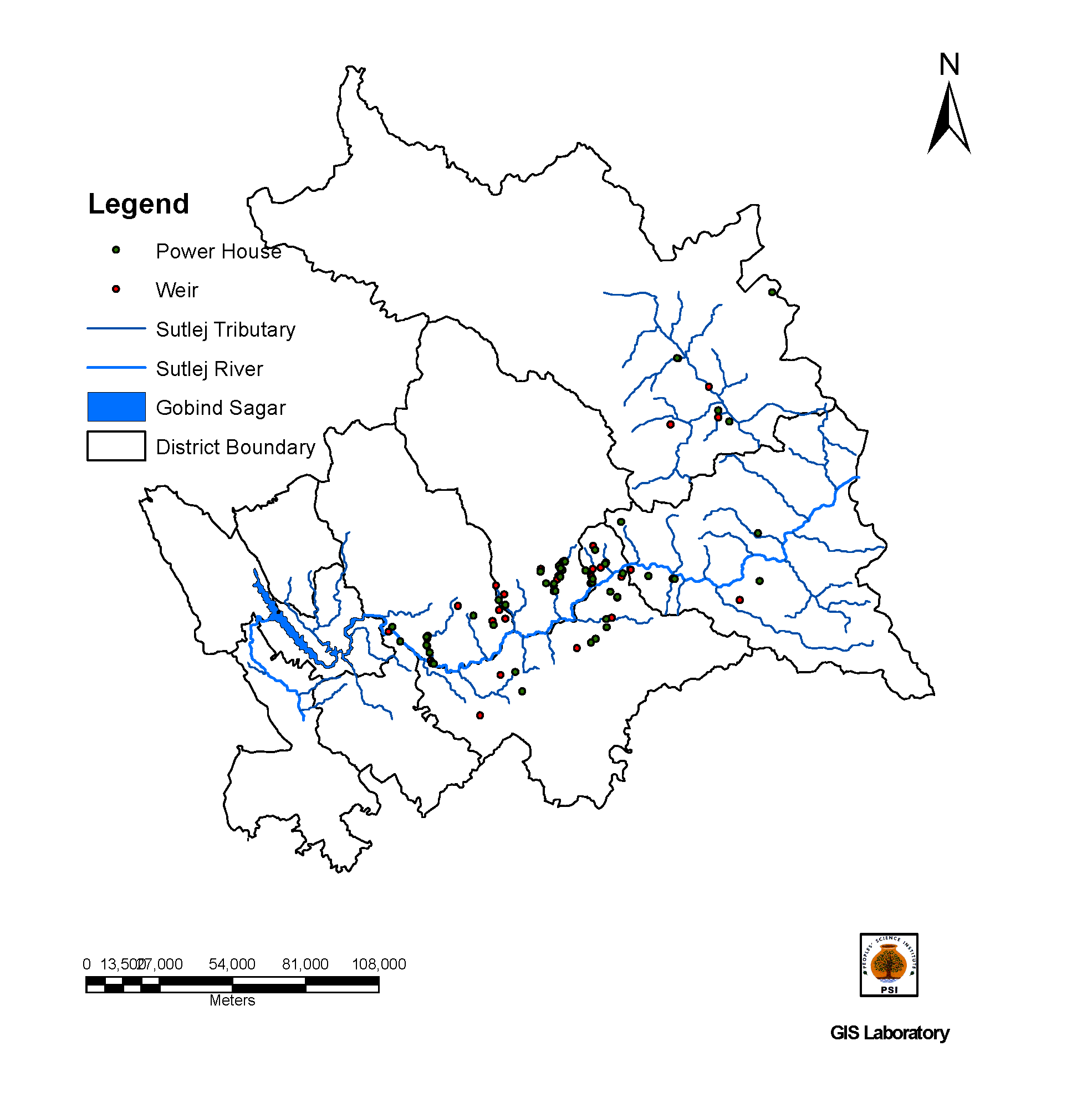
Hydro Power Development in the Satluj River Basin
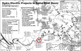
Despite significant ecological and social concerns, hydro power development continues to expand in the Satluj River Basin. Here’s an overview of the current and planned projects:
Current and Planned Hydropower Projects
Major Projects Under Construction:
- Shongtong Karcham: 450 MW
- Integrated Kashang: 243 MW
Proposed Projects:
- Khab: 636 MW (Central/Joint Sector)
- Luhri: 775 MW (Central/Joint Sector)
- Jangi Thopan Powari: 960 MW (Private Sector)
- Yangthang Khab: 261 MW (Private Sector)
Projects Awaiting Tender:
- Jangi Thopan Powari and Yangthang Khab are waiting to be tendered, involving private sector interests.
Identified Projects:
- Several projects are either allotted or under investigation, indicating ongoing expansion plans.
Summary of Current and Upcoming Hydro Projects
Stage | Large Projects Installed Capacity (MW) | Small Projects Installed Capacity (MW) |
Commissioned | 9 (5,780.23 MW) | 15 (90.25 MW) |
Under Construction | 3 (730 MW) | 18 (159.1 MW) |
Planning | 9 (2,967 MW) | 88 (304.55 MW) |
Total | 21 (9,477.23 MW) | 121 (553.9 MW) |
- Source: (Govt. of HP, 2014-15; HIMURJA, 2015)
Proposed Projects on the Spiti River
- Lara Sumta Project:
- Location: Near Tabo Village, Lahaul & Spiti District
- Land Requirement: 97.75 ha (79.50 ha forest land, 18.50 ha private land)
- Sumte-Kothang Dam:
- Location: Near Hurling Village
- Powerhouse: Underground on the right bank of the river near Chango village (2 units of 65 MW)
- Head Race Tunnel (HRT): 10.84 km with a 6.20 m diameter
- Tail Race Tunnel (TRT): 286 m long with a 6.20 m diameter
- Land Requirement: 110 ha (87 ha forest land, 23 ha private land)
- Submergence Area: 32.20 ha
- Chango Yangthang Project:
- Land Requirement: 146 ha (72 ha barren un-demarcated forest land, 40 ha submerged; includes private land and NH22 portion)
- Yangthang Khab Project:
- Planned as a follow-up to Chango Yangthang.
- Khab Shaso Project:
- Initially proposed but met with significant local opposition, currently shelved.
Concerns and Issues
Environmental Impact:
- Forests and Land Use: Many projects require substantial forest land and private land, leading to deforestation and habitat destruction.
- Submergence Areas: Large areas of land are submerged, affecting local ecosystems and communities.
Social Impact:
- Local Opposition: Projects like Khab Shaso faced strong resistance from local communities, highlighting issues of displacement and loss of livelihood.
Ecological Considerations:
- The rapid expansion of hydroelectric projects raises concerns about the ecological balance, soil erosion, and impacts on local biodiversity, including the potential disruption of riverine ecosystems.
Regulatory and Planning Challenges:
- Assessment and Regulation: There is often criticism regarding inadequate environmental impact assessments and the lack of comprehensive regulatory oversight for these large-scale projects.
The continued development of hydro power in the Satluj River Basin reflects a complex balance between energy needs, environmental sustainability, and social impacts.
Ravi River Basin Overview
The Ravi River Basin is an integral part of the River System in Himachal Pradesh. Here are the essential facts about this important river basin:
- Length: The Ravi River flows for 158 kilometers within Himachal Pradesh, contributing to its total length of 720 kilometers (with 320 kilometers in India and 400 kilometers in Pakistan).
- Source: It originates from Multan Tehsil in the Kangra District of Himachal Pradesh.
- Districts Traversed: In Himachal Pradesh, the river traverses the districts of Kullu and Chamba.
- Catchment Area: The basin encompasses a catchment area of 5,528 square kilometers, which accounts for 9.9% of the total area of Himachal Pradesh.
Hydroelectric Projects
- Commissioned, Under Construction & Planned: The Ravi River Basin hosts 167 hydroelectric projects with a cumulative installed capacity of 2,835.12 MW.
- Potential Capacity: The total potential capacity for hydroelectric power generation in the basin is estimated at 3,237 MW.
Main Tributaries
The major tributaries of the Ravi River include:
- Siyul
- Budhil
- Tantgiri
- Saal
The Ravi River Basin is a crucial element of the River System in Himachal Pradesh, playing a significant role in regional water resources and hydroelectric power generation.

River Narratives
Historical Names:
- Known as Parushani or Iravati in Vedic times
- Referred to as Hydraotes by the Ancient Greeks
Source and Course:
- Source: Bara Banghal area, Multhan tehsil, Kangra district, Himachal Pradesh
- Originates from the glaciated regions of Beas Kunderi Dhar, forming from the confluence of Bhadal Nalla, Rai Nalla, and Tantgari Nalla.
- Course: Flows north-west through Himachal Pradesh and Punjab, meeting the Punjab plains near Madhopur before entering Pakistan.
Catchment Area:
- Total Basin Catchment Area: 14,442 sq. km
- Himachal Pradesh Catchment Area: Approximately 5,451 sq. km
Climate and Rainfall:
- Climate: Influenced by tropical weather systems in summer and Western Disturbances in winter.
- Western Disturbances: Originate near the Mediterranean and impact the region during winter.
- Southwest Monsoon: Dominates from June to September, contributing to summer precipitation.
- Average Annual Rainfall: 1,370 mm
- Peak Rainfall: August (20% of annual total)
- Winter Rainfall: January to March (26% of annual total, influenced by Western Disturbances)
Tributaries
- Bhadal River:
- Source: Snowy range between Pir Panjal and Dhauladhar ranges, Bara Banghal area.
- Features: Flows westerly, merging with the Tant Gari river. Characterized by U-shaped valleys, waterfalls, and moraines.
- Tant Gari River:
- Source: Slopes of an off-shoot of the Pir Panjal range, east of Bharmaur, Chamba district.
- Features: U-shaped valley with boulders and morainic deposits from past glaciation.
- Budhil and Dhona (Nai):
- Budhil River:
- Source: Manimahesh Kailash Peak and Manimahesh Lake, Lahaul range.
- Features: Flows through Bharmour, Himachal Pradesh; historically used for Deodar timber.
- Nai (Dhona):
- Source: Kali Debi Pass.
- Joining Point: Joins Ravi at Triloknath.
- Budhil River:
- Siul River:
- Source: Tract between Dhauladhar and Pir Panjal ranges.
- Features: Flows east, then south-west into the Ravi River. Fed by snowmelt and springs.
- Baira River:
- Source: Southern slopes of the Pir Panjal range.
- Features: Joins Siul River, characterized by steep slopes and deep valleys.
Hydropower Development

- Current Hydropower Capacity:
- Commissioned: 2,835.12 MW across 167 projects
- Potential Capacity: 3,237 MW
- Planned and Proposed Projects:
- Potential for Expansion: Additional projects are likely to be proposed, focusing on harnessing the river’s full potential.
The Ravi River Basin’s complex interplay of historical, geographical, and climatic factors contributes to its significance in the region. Its hydropower potential is substantial, but it is balanced by the ecological and social impacts associated with development.
Hydropower Development in the Ravi River Basin
Overview of Hydropower Projects
The Ravi River Basin has been a focal point for hydropower development since the 1980s. The region has been extensively harnessed for its hydroelectric potential, leading to the construction of several significant projects.
Historical and Current Major Projects:
- Baira-Suil Hydroelectric Power Project
- Capacity: 198 MW
- Location: On the Budhil stream, Chamba District.
- Operational Since: 1980s
- Chamera-I Hydroelectric Power Project
- Capacity: 540 MW
- Commissioned: 1994
- Features: Concrete arch gravity dam, 141 m high, 295 m long, with a reservoir extending 18 km upstream along the Ravi and 11 km along the Siul. Affected 1554 families, with 433 requiring resettlement.
- Chamera-II Hydroelectric Power Project
- Capacity: 300 MW
- Commissioned: 2004
- Location: Upstream of Chamera-I
- Chamera-III Hydroelectric Power Project
- Capacity: 231 MW (3 x 77 MW turbines)
- Operational Since: 2012
- Features: Third stage of Chamera Dam
- Budhil Hydro Project
- Capacity: 70 MW
- Location: Budhil stream, Chamba District
- Operational Since: October 2012
- Transmission: 18 km to the PGCIL 220 kV Chamera Grid sub-station
Proposed and Upcoming Projects:
- Holi Bajoli Hydroelectric Project
- Description: Proposed project to harness head between Bajoli and Holi villages. Affected areas include a diversion site near Nayagram and a powerhouse site near Barola village.
- Concerns: Potential impacts on local horticulture and compliance with Forest Rights Act (FRA) 2006.
- Kutehr Hydroelectric Project
- Capacity: 240 MW
- Location: Upstream of Holi Bajoli
- Status: Under investigation
- Bajoli-Holi Hydroelectric Project
- Location: Vicinity of Dhauladhar Wildlife Sanctuary
- Concerns: Massive resistance from local communities due to potential impacts on horticulture and forest land.
Hydropower Development Summary
Current and Planned Projects:
- Commissioned Large Projects: 5 projects with a total capacity of 1,339 MW
- Under Construction: 2 projects with a total capacity of 216 MW
- Planning: 7 large projects with a total potential capacity of 684 MW
Small Projects:
- Commissioned: 18 projects with a total capacity of 75.45 MW
- Under Construction: 8 projects with a total capacity of 29.5 MW
- Planning: 127 small projects with a total potential capacity of 491.17 MW
Total Installed Capacity:
- Large Projects: 2,239 MW
- Small Projects: 596.12 MW
The Ravi River Basin continues to be a critical area for hydroelectric development, balancing energy needs with environmental and social considerations. The development’s trajectory is shaped by ongoing challenges, including ecological impacts, community displacement, and climate change
Chenab River Basin Overview
The Chenab River, a prominent river in the River System in Himachal Pradesh, flows through northern India and into Pakistan, making it a significant player in regional hydrology and hydropower development. Here’s a detailed overview:
- Length: The Chenab River extends 122 kilometers within Himachal Pradesh.
- Source: It originates from the Bara Lacha Pass in the Lahaul-Spiti region.
- Districts Traversed: In Himachal Pradesh, the river flows through the districts of Lahaul-Spiti and Chamba.
- Catchment Area: The Chenab River Basin has a catchment area of 7,850 square kilometers, which represents 14.2% of Himachal Pradesh’s total area.
Hydropower Potential
- Potential Capacity: The Chenab River Basin has a substantial hydropower potential of 4,032 MW.
- Hydropower Projects: There are 50 hydroelectric projects either commissioned or planned in the basin, with a combined capacity of 3,085.25 MW.
Main Tributary
- Miyar Nalla: The primary tributary of the Chenab River.
The Chenab River Basin is a critical component of the River System in Himachal Pradesh, offering significant opportunities for hydropower development due to its high discharge and steep gradients.
River System and Geography
- Formation: The Chenab River is formed by the confluence of two streams, Chandra and Bhaga, originating from the Bara Lacha Pass.
- Chandra River: Flows southeast for about 88 km.
- Bhaga River: Flows northwest for 80 km.
- Confluence: At Tandi, where Chandra and Bhaga meet to form the Chenab.
- Course:
- After the confluence, the Chenab flows northwest for about 46 km before receiving the Miyar Nalla tributary.
- It then flows northward through Himachal Pradesh and into Jammu & Kashmir.
- Catchment Area: Extends over 29,050 sq. km up to the international border, with about 6,242 sq. km under perpetual snow.
Hydropower Projects
Major and Planned Projects:
- Jispa Hydroelectric Project
- Capacity: Planned
- Location: Near Jispa, Lahaul-Spiti
- Concerns: Potential environmental impacts including deforestation and displacement.
- Karcha Hydro Project
- Capacity: Planned
- Location: Upstream of the Chenab, in Chamba District
- Concerns: Possible effects on local ecosystems and communities.
- Tandi Project
- Capacity: Planned
- Location: At the confluence of Chandra and Bhaga rivers
- Concerns: Potential impacts on sacred sites and local communities.
Historical Projects:
- Bhaga Hydro Project
- Capacity: Commissioned
- Location: Near Bhaga River, Chamba District
- Chandra Hydro Project
- Capacity: Commissioned
- Location: Near Chandra River, Lahaul-Spiti
Hydropower Development Summary
Current and Planned Capacity:
- Commissioned Projects: Several small and large-scale projects have been implemented.
- Planned Projects: Additional projects are proposed, targeting an increase in the total hydropower capacity.
Total Capacity:
- Commissioned and Planned Projects Combined: 3,085.25 MW
- Potential Capacity: 4,032 MW
The Chenab River Basin represents a significant opportunity for hydropower development due to its high discharge and steep gradients. However, the potential environmental, cultural, and ecological impacts of these projects require careful consideration and management. Balancing energy needs with environmental conservation and local community interests remains a critical challenge in the development of this region.
Beas River Basin Overview
The Beas River is a crucial component of the River System in Himachal Pradesh, renowned for its significant hydropower potential and extensive catchment area. Here’s a comprehensive overview:
- Length: The Beas River extends 286 kilometers within Himachal Pradesh, contributing to its total length of 460 kilometers.
- Source: It originates from Beas Kund, located near the Rohtang Pass.
- Districts Traversed: The river flows through the districts of Kullu, Mandi, and Kangra.
- Catchment Area: The Beas River Basin covers a catchment area of 13,663 square kilometers, which constitutes 24.5% of Himachal Pradesh’s total area.
Hydropower Potential
- Potential Capacity: The Beas River Basin has a notable hydropower potential of 5,995 MW.
- Hydropower Projects: There are 359 hydroelectric projects either commissioned or planned in the basin, with a total installed capacity of 5,463 MW.
Main Tributaries
The major tributaries of the Beas River include:
- Parbati
- Tirthan
- Sainj
- Harla
- Gaj Khad
- Chakki
- Luni
- Mamuni
- Uhl
- Neugal
The Beas River Basin is a key feature of the River System in Himachal Pradesh, with its extensive hydropower potential playing a crucial role in the region’s energy landscape.
River System and Tributaries
Main Tributaries:
- Parbati River
- Origin: Manatalai Glacier at 5,200 meters above sea level
- Length: 85 km (approximately)
- Characteristics: Flows through rocky terrain and dense forests, fed by snowmelt and rainfall.
- Tirthan River
- Origin: Base of the Himalayan mountain range in South-East Kullu
- Flow: South-West, joins Beas at Larji
- Sainj River
- Course: V-shaped valley, flowing south-west
- Uhl River
- Origin: Northern Dhauladhar Range
- Characteristics: Joins Beas at Mandi, predominantly flows through mountainous regions of Kangra
- Neugal River
- Origin: Dhauladhar Hills
- Characteristics: Perennial river crucial for drinking water and irrigation
- Harla River
- Location: North-western Kullu, joins Beas near Kullu Airport (Bhuntar)
- Gaj Khad
- Origin: Dhauladhar Range
- Characteristics: Small, snow-fed stream, joins Beas at Maharana Pratap Sagar Lake
- Chakki River
- Origin: Rain and snow-fed
- Course: Flows through South-Eastern Himachal Pradesh, joins Beas at Pathankot in Punjab
- Luni River
- Origin: Southern Dhauladhar Range
- Flow: Joins Beas in Kangra Valley
- Mamuni River
- Characteristics: Steep gradient, used for cultivation on its riverbed
Hydropower Projects

Current and Planned Capacity:
- Total Capacity (Commissioned + Planned): 5,463 MW
- Potential Capacity: 5,995 MW
Major Projects:
- Pong Dam (Beas Dam)
- Capacity: Major multipurpose project
- Location: Near the confluence of the Beas and Satluj Rivers
- Koldam Hydroelectric Project
- Capacity: 800 MW
- Location: Near Koldam in Bilaspur District
- Larji Hydroelectric Project
- Capacity: 126 MW
- Location: Larji in Kullu District
- Sainj Hydroelectric Project
- Capacity: 100 MW
- Location: Sainj Valley, Kullu District
- Parbati III Hydroelectric Project
- Capacity: 520 MW
- Location: Parbati Valley, Kullu District
Future Projects:
- Additional Small and Large-scale Projects: Numerous projects are planned or under development to harness the remaining hydropower potential.
Critical Issues and Impacts
- Environmental Impacts:
- Aquatic Life: The Beas River and its tributaries are vital for local fish fauna. Several tributaries are spawning grounds for fish, and hydropower projects could disrupt migration and breeding patterns.
- Deforestation: Construction of hydropower projects may lead to significant deforestation, impacting biodiversity and forest ecosystems.
- Cultural and Social Impacts:
- Local Communities: Hydropower projects could affect local communities, including those relying on the river for agriculture and daily needs.
- Sacred Sites: Certain areas along the river are culturally significant, and development could impact traditional practices and local heritage.
- Ecological Concerns:
- Water Flow and Ecosystems: Changes in river flow due to dam construction could impact downstream ecosystems and reduce water availability for irrigation and drinking.
- Sedimentation: Increased sedimentation due to construction activities could affect water quality and aquatic habitats.
- Climate Change:
- Glacial Melting: The Beas River’s flow is partly fed by glacier melt. Climate change-induced glacial melting may affect river flow and hydropower generation in the future.
Summary
The Beas River basin offers significant hydropower potential due to its substantial flow and large catchment area. However, the development of numerous hydropower projects raises concerns about environmental impacts, cultural heritage, and ecological balance. Balancing hydropower development with the preservation of natural and cultural resources is crucial for sustainable development in this region.
Mythology, Ecology, and Economy of the Beas River Basin
Mythology
The Beas River, known in ancient times as Vipasa, plays a prominent role in the historical and mythological narratives of the region:
- Alexander the Great:
- The Beas River marked the easternmost limit of Alexander the Great’s conquests in 326 BC. It was a significant obstacle in his invasion of India, representing a natural boundary that shaped historical events.
- Name Origin:
- The river’s name, Beas, is derived from its Sanskrit name ‘Vipasha.’ Some traditions link its origin to the sage Vyasa, with the belief that the river starts from Vyasa Kund.
- Parbati River Folklore:
- Manikaran Legend: According to local lore, Lord Shiva and Goddess Parbati were mesmerized by the beauty of the Parbati Valley and spent 3,000 years there. During their stay, Parbati lost her earring, leading Shiva to use his third eye to search for it, which caused cosmic disturbances. To calm Shiva, Sheshnag (the serpent god) intervened, causing hot springs to emerge, which revealed precious stones that resembled Parbati’s earring.
- Religious Significance of Manikaran:
- Sikh Belief: Manikaran is also a sacred site for Sikhs. Guru Nanak, accompanied by his disciple Bhai Mardana, is said to have visited the spot. When Mardana couldn’t cook the rotis due to the absence of fire, Guru Nanak suggested praying for the rotis to float. When they did float back up, it was seen as a sign of divine providence.
Ecology
The Beas River basin showcases diverse ecological features, ranging from temperate forests to alpine meadows:
- Climate and Vegetation:
- Climate Zones: The climate varies from temperate at the origin to sub-tropical downstream.
- Forests: The Kullu District has rich cedar forests (Himalayan Moist Temperate), while Mandi and Kangra feature deciduous sub-tropical mixed forests. Key tree species include Deodar, Fir, Spruce, Alder, Poplar, and Walnut.
- Alpine Vegetation: Above 3,000 meters, vegetation is mostly herbs and shrubs with occasional trees. Major species include Birch, Juniper, Willow, Artemisia, and medicinal plants like Kutki (Picrorhiza kurroa) and Atis (Aconitum heterophyllum).
- Medicinal Plants and Agriculture:
- Medicinal Plants: The Parbati, Sainj, and Tirthan Valleys are significant for medicinal plant trade, crucial to the local economy. Important species include Atish (Aconitum heterophyllum), Karu (Picrorhiza kurroa), and Bankakiri (Podophyllum hexandrum).
- Agricultural Practices: The Kullu District’s agro-climatic conditions favor apple orchards and grasslands above the tree line for grazing. Commonly cultivated plants include Quercus spp., Alnus nitida, and fodder species like Morus serrata and Celtis australis.
- Wildlife:
- Mammals: The Great Himalayan National Park (GHNP) in the Parbati Valley is home to Musk Deer, Himalayan Tahr, Bharal (Blue Sheep), and rarely Snow Leopards and Himalayan Black Bears.
- Birds: The park hosts species like the Monal Pheasant, Western Tragopan, Himalayan Griffon, Lammergeier, Golden Eagle, and various butterflies.
- Vegetation Along Banks: Includes Alnus, Salix, and Conifers, with agro-climatic conditions supporting crops such as potato, ginger, apples, and off-season vegetables.
Economy
The economy of the Beas River basin is predominantly agricultural, with significant activities related to horticulture and cash crops:
- Agriculture:
- Primary Occupation: Over 80% of the population is engaged in agriculture. The terrain is varied, with soil ranging from sandy loam to clay loam, and acidic in nature.
- Crops: Traditional crops like wheat and potato have been largely replaced by apple orchards, particularly in Kullu and Mandi districts. In Kangra, tributaries support irrigation for paddy cultivation.
- Horticulture:
- Variety of Crops: The region is known for its production of temperate and sub-tropical crops, including apples, peaches, apricots, chestnuts, almonds, cherries, gooseberries, and olives.
- Challenges and Opportunities:
- Small Holdings: Farming practices involve small, terraced fields, limiting mechanization and affecting production levels.
- Economic Diversification: Horticulture and the trade of medicinal plants play a vital role in the regional economy, providing opportunities for economic development.
In summary, the Beas River basin is rich in cultural heritage, ecological diversity, and economic potential. Its mythology highlights historical and religious significance, while its diverse ecosystems support a variety of flora and fauna. The region’s economy, driven by agriculture and horticulture, reflects the adaptation of local communities to the unique challenges and opportunities of their environment.
Yamuna River Basin: Essential Facts, Narratives, and Tributaries
The Yamuna River Basin is a crucial element of the River System in Himachal Pradesh, contributing to the region’s hydrology and energy resources. Here’s a detailed look at the basin:
Essential Facts
- Length in Himachal Pradesh: The Yamuna River flows for 22 kilometers within Himachal Pradesh, out of a total length of 1,376 kilometers.
- Source: It originates from the Saptarishi Kund, which is fed by the Yamunotri Glacier in Uttarakhand.
- Districts in Himachal Pradesh: The river traverses the districts of Shimla and Sirmaur.
- Catchment Area: The Yamuna River Basin covers a catchment area of 5,872 square kilometers, making up 10.6% of Himachal Pradesh’s total area.
Hydroelectric Projects
- Current Projects: There are 95 hydroelectric projects in the Yamuna River Basin, with a combined installed capacity of 672.75 MW.
- Potential Capacity: The basin has a potential hydropower capacity of 840 MW.
Main Tributaries
The Yamuna River Basin is fed by several important tributaries:
- Giri
- Tons
- Pabbar
The Yamuna River Basin, as part of the River System in Himachal Pradesh, plays a significant role in regional water resources and energy production. Its tributaries and potential for hydroelectric power development underscore its importance in the region’s ecological and economic landscape.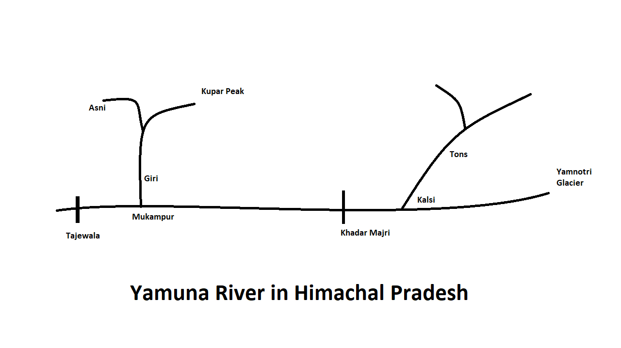
River Narratives
The Yamuna River has significant historical, mythological, and geographical importance:
- Geographical Origin and Flow:
- The Yamuna originates from the Saptarishi Kund at the base of the Banderpoonch peak in the Champasar glacier, located at an altitude of 4,420 meters. It flows through Uttarakhand for about 170 km before forming a border between Himachal Pradesh and Uttarakhand. The river then continues its journey through the plains of northern India, eventually meeting the Ganga at Prayag (Allahabad).
- Historical and Mythological Significance:
- Connection with Saraswati: It is believed that the Yamuna was originally a tributary of the now-extinct Saraswati River. Tectonic shifts during the Vedic period altered the drainage pattern, causing the Yamuna to flow southeastward, running parallel to the Ganga.
- Mythological Origin: In Hindu mythology, Yamuna is the daughter of Surya (the Sun God) and his wife Sanjna, and is the twin sister of Yama, the god of death. Her frequent meandering is linked to the myth that she is a quivering river due to her inability to look directly at the Sun God.
Tributaries
- Tons River:
- Source and Flow: The Tons River rises at an elevation of 3,900 meters and joins the Yamuna near Kalsi. It flows through Shimla and Sirmaur districts, forming a boundary between Uttarakhand and Himachal Pradesh before entering Sirmaur and merging with the Yamuna at Khodar Majri.
- Local Communities: The river basin is inhabited by the Jaunasari and Bawar tribes, who have rich traditions involving medicinal plants and fishing. The area is characterized by a complex social structure with land ownership predominantly held by Rajputs and Brahmins.
- Tributaries: The Pabbar River, which joins the Tons near the Chakrata massif, is a significant contributor. The Pabbar originates from the Dhauladhar range and is fed by glaciers and springs.
- Pabbar River:
- Source and Flow: Originates from the Dhauladhar range near Shimla, and merges with the Tons River at the base of the Chakrata massif. The Pabbar River is essential for the local communities who engage in farming, apple cultivation, and forest-based livelihoods.
- Tributaries: The Andhra River, rising from a small glacier in Shimla district, merges with the Pabbar at Chigaon.
- Giri River:
- Source and Flow: The Giri River, also known as Giriganga, rises from Kupar Peak above Jubbal. It flows southeast through Shimla’s hills, dividing Sirmaur district into Cis-Giri and Trans-Giri regions before joining the Yamuna upstream of Paonta.
- Hydrological Role: The Giri River’s waters are harnessed for drinking and irrigation purposes. It contributes significantly to the water needs of Shimla and Solan and supports local agriculture.
- Tributaries: Includes the Ashni River, joining near Sadhupul, and the Jalal River, merging at Dadahu.
Ecology
- Vegetation and Wildlife:
- Catchment Areas: The river catchments have diverse vegetation, including scrub forests, broad-leaved forests, and pastures. In the higher elevations, there are dense forests interspersed with grasslands.
- Fish Species: The rivers support species like snow trout and Mahaseer.
- Economic and Livelihood Activities:
- Agriculture and Horticulture: The region’s economy is heavily reliant on agriculture, including cash crops like apples and various forest-based activities.
- Medicinal Plants: Local communities use medicinal plants for traditional remedies, with a recorded use of about 100 species.
In summary, the Yamuna River basin, while relatively short in Himachal Pradesh, is crucial both ecologically and culturally. It supports a variety of economic activities, provides essential water resources, and is steeped in mythological significance that connects it with ancient rivers and deities. Hydropower Development in the Yamuna River Basin
Sawra-Kuddu Project
- Location: Pabbar River, Shimla District, Himachal Pradesh
- Capacity: 111 MW
- Type: Run-of-river
- Current Status: Under construction; originally scheduled for December 2011, now expected to be operational by July 2017.
- Funding: Himachal Pradesh Clean Energy Development Investment Program, funded by the Asian Development Bank.
- Infrastructure:
- Dam Site: Hatkoti Village, Rohru Tehsil
- Power House: Snale Village, close to the Uttarakhand border
- Catchment Area: 1,034 sq. km in Himachal Pradesh
- Environmental and Social Impacts:
- Land Acquisition: 45 ha of private land and 53 ha of forest land acquired.
- Local Impact: Cracks in houses and roads due to tunneling; approximately 40 water sources have dried up.
- Communities Affected: 12 Panchayats, with particular concerns in Thana village.
Hydroelectric Projects Summary in the Yamuna Basin (Himachal Pradesh):
- Large Projects:
- Commissioned: 1 project (60 MW)
- Under Construction: 3 projects (179 MW)
- Planning: 4 projects (215 MW)
- Small Projects:
- Commissioned: 11 projects (49.95 MW)
- Under Construction: 7 projects (27 MW)
- Planning: 69 projects (141.8 MW)
Renuka Dam Project
- Location: Giri River, Sirmaur District, Himachal Pradesh
- Capacity: 40 MW
- Dimensions: 148 meters high, 430 meters wide
- Storage Capacity: 45,640 ha m
- Water Supply: 23 cumecs to Delhi; additional 93.83 MU power from the existing 60 MW Giri HEP.
- Environmental and Social Impacts:
- Land Acquisition: 1,231 hectares of agricultural land; 909 hectares of reserved forestland, including 49 hectares of Renuka Wildlife Sanctuary.
- Challenges: Complex forest clearance issues and impact on protected areas; issues with acquiring shamlaat lands (private forests).
Kishau Dam
- Location: Tons River, Himachal Pradesh
- Capacity: 660 MW
- Height: 236 meters (second highest dam in India)
- Irrigation: Provides water to 97,076 hectares across five states (Haryana, Rajasthan, Delhi, Uttar Pradesh, Uttarakhand)
- Drinking Water Supply: Augments Delhi’s supply by 619 million cubic meters.
- Environmental and Social Impacts:
- Submergence Area: 2,950 hectares (512 ha cultivated land, 2,438 ha forest land)
- Affected Villages: 9 from Uttarakhand, 8 from Himachal Pradesh (6 from Sirmour, 2 from Shimla)
- Displacement: Affects 5,498 people from 701 families.
- Cost-Benefit Analysis: Poor ratio for Himachal Pradesh; the state will get 50% share in power, no share in irrigation, and significant land loss and displacement.
General Challenges in Hydropower Development

- Environmental Concerns:
- Deforestation and loss of protected areas.
- Altered river flow impacting downstream ecosystems.
- Drying up of water sources.
- Social Impacts:
- Displacement of local communities and loss of agricultural land.
- Potential destruction of local infrastructure due to construction activities.
- Disputes over fair compensation and adequate measures for affected families.
- Legal and Policy Issues:
- Navigating forest and environmental clearances, particularly for protected areas.
- Balancing inter-state water sharing agreements and local impacts.
- Infrastructure and Economic Factors:
- Large projects like Kishau Dam face complex cost-benefit analyses due to their scale and inter-state implications.
- Financial and logistical challenges related to project execution and completion timelines.
In summary, hydropower development in the Yamuna River Basin involves a complex interplay of energy needs, environmental protection, and social impacts. Each project has specific benefits and challenges, with varying implications for local communities and ecosystems.
Summary of the River System in Himachal Pradesh
The River System in Himachal Pradesh is a crucial element of the region’s geography, hydrology, and economy. It encompasses several major rivers, each contributing significantly to the state’s water resources and hydroelectric potential.
Satluj River Basin: The River System in Himachal Pradesh includes the Satluj River, which flows 320 kilometers through districts such as Lahaul-Spiti, Kinnaur, Shimla, Kullu, Mandi, and Bilaspur. The basin’s catchment area and hydroelectric projects highlight its importance within the River System in Himachal Pradesh.
Ravi River Basin: Another key component of the River System in Himachal Pradesh is the Ravi River, extending 158 kilometers within the state. It traverses the districts of Kullu and Chamba and has a significant catchment area and hydropower potential, demonstrating its role in the River System in Himachal Pradesh.
Chenab River Basin: The Chenab River, originating in the Lahaul-Spiti region, flows 122 kilometers within Himachal Pradesh. Its substantial catchment area and potential for hydropower development underscore its significance in the River System in Himachal Pradesh.
Beas River Basin: The Beas River, stretching 286 kilometers in Himachal Pradesh, is a major river in the River System in Himachal Pradesh. It has a large catchment area and considerable hydropower potential, reflecting its critical role in the region’s River System in Himachal Pradesh.
Yamuna River Basin: The Yamuna River, though shorter within Himachal Pradesh at 22 kilometers, is an essential part of the River System in Himachal Pradesh. Its tributaries and hydropower projects highlight its contributions and challenges within the broader River System in Himachal Pradesh.
Overall, the River System in Himachal Pradesh is characterized by its diverse rivers and basins, each contributing to the state’s water resources and hydroelectric capacity. Effective management of these river systems is crucial for balancing energy needs, environmental conservation, and social impacts, ensuring the sustainable development of the River System in Himachal Pradesh.