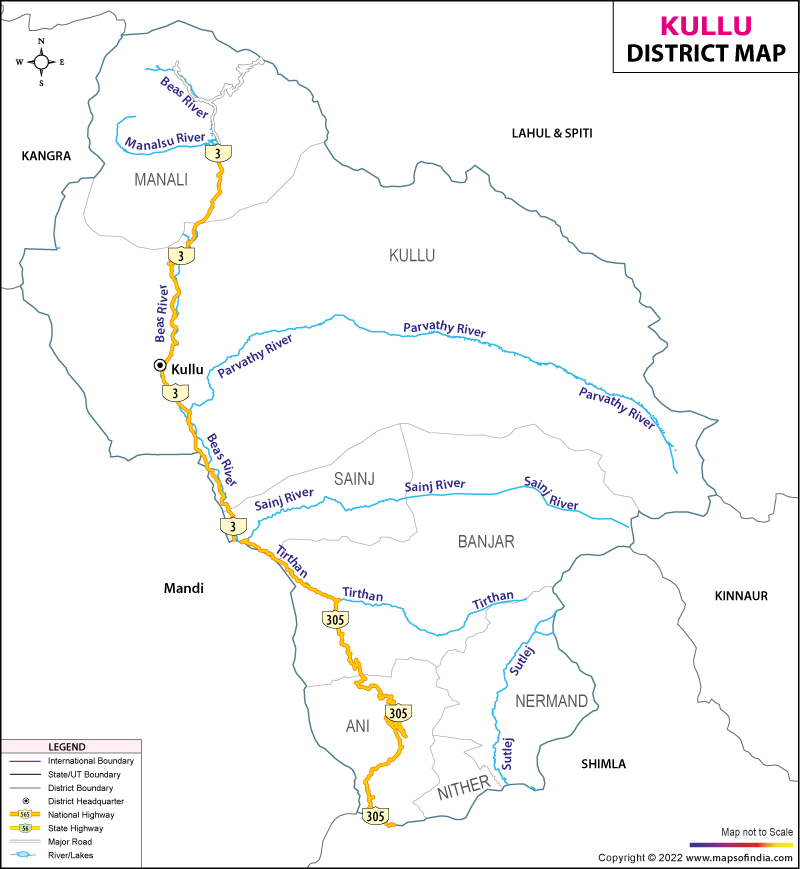
Brief Geography of Kullu District
Geographical Location:
Kullu is a district in Himachal Pradesh, India, bordered by:
- South: Shimla district
- West: Mandi and Kangra districts
- East: Kinnaur
- North and East: Lahaul and Spiti district
Kullu Valley:
- Largest Valley: The Kullu Valley is the most prominent feature of the district.
- Elevation Range: From 833 meters at Aut to 3,330 meters at the Atal Tunnel South Portal below Rohtang Pass.
Administrative Headquarters:
- Location: Town of Kullu, situated on the right side of the Beas River.
Riverine Tributary Valleys:
- Major Rivers: Beas, Parvati, Sainj, and Tirthan.
Economic Activities:
- Main Sectors: Horticulture, agriculture, tourism, and traditional handicrafts.
कुल्लू जिला – हिमाचल प्रदेश का संक्षिप्त भूगोल
कुल्लू जिला मध्य हिमाचल प्रदेश के पूर्वी भाग में स्थित एक महत्वपूर्ण भौगोलिक क्षेत्र है। यहां का भूगोल इसके प्राकृतिक सौंदर्य और पारिस्थितिकी की विविधता को दर्शाता है। इस लेख में कुल्लू जिले के प्रमुख भौगोलिक तत्वों, जलवायु, मिट्टी, और नदी प्रणालियों का विस्तृत वर्णन प्रस्तुत किया गया है।
स्थान और आकार
- भौगोलिक स्थिति: कुल्लू जिला 31°20′25″ से 32°25′0″ उत्तरी अक्षांश और 76°56′30″ से 77°52′20″ पूर्वी देशांतर के बीच स्थित है।
- मुख्यालय: सरवरी नाले और ब्यास नदी के संगम पर समुद्र तल से 1,200 मीटर की ऊंचाई पर स्थित।
- क्षेत्रफल: 5,503 वर्ग किलोमीटर (राज्य के कुल क्षेत्रफल का 9.88 प्रतिशत)।
- जनसंख्या रैंक: 9वें स्थान पर।
उप-सूक्ष्म क्षेत्र
कुल्लू जिले को भौगोलिक स्थिति, जलवायु, मिट्टी, भूविज्ञान और वनस्पति के आधार पर पाँच उप-सूक्ष्म क्षेत्रों में विभाजित किया गया है:
कुल्लू घाटी
- स्थिति: ब्यास नदी के दोनों किनारों पर और पार्वती और तीर्थन जैसी प्रमुख सहायक नदियों के निचले हिस्सों पर।
- समुद्र तल से ऊंचाई: 1,089 मीटर से 2,980 मीटर।
- जलवायु: गर्मियों में गर्म और सर्दियों में ठंडी; ऊपरी इलाकों में बर्फबारी।
- भूविज्ञान: मुख्यतः मध्य प्रोटेरोज़ोइक संरचनाओं से बना; उत्तरी किनारे में ग्रेनाइट, दक्षिण-पूर्वी भाग में शाली-देवबन और रामपुर-बंजार संरचनाएँ।
- मिट्टी: ओर्थेंट्स-ओक्रेप्ट्स (58%), यूडाल्फ्स (20%).
- वनस्पति: ऊंची ढलानों पर देवदार की मिश्रित वनस्पति।
कुल्लू वन
- स्थिति: कुल्लू घाटी के आसपास; मनाली, कुल्लू, बंजार तहसीलों और सैंज उप-तहसील के कुछ हिस्से।
- समुद्र तल से ऊंचाई: 2,800 मीटर से 4,953 मीटर।
- जलवायु: ठंडी और शुष्क; ऊंचे इलाकों में बर्फबारी।
- भूविज्ञान: जुटोग समूह/वैकृता समूह, केंद्रीय गनीस, ग्रेनाइट; नागथात, मुल्ह और मणिकरण क्वार्टजाइट।
- मिट्टी: ऑर्थेंट्स-ओक्रेप्ट्स (58%), यूडाल्फ्स (20%), ग्लेशियर और स्नोकैप (103%).
- वनस्पति: घने जंगल; चीड़, कैल, सिल्वर फर, अखरोट, हॉर्स चेस्टनट, ओक, देवदार।
कुल्लू ग्रेटर हिमालय
- स्थिति: उत्तर और पूर्वी कुल्लू जिले से गुजरता है; कुल्लू और मनाली तहसीलों के पूर्वी भाग, सैंज उप-तहसील का उत्तर-पूर्वी छोर।
- समुद्र तल से ऊंचाई: 4,012 मीटर से 6,632 मीटर।
- महत्वपूर्ण धार: अली रत्नी धार (5,269 मीटर), घोडिल धार (4,220 मीटर), सिरखंड धार (5,159 मीटर), धरिंग धार (4,183 मीटर).
- ग्लेशियर: दुधोन, पार्वती, टिचू, सारा उमगा, डिबी।
- भूविज्ञान: ग्रेनाइट्स (अवर्गीकृत), हैमंता समूह, जुटोघ समूह।
- मिट्टी: यूडाल्फ़्स (20%), ओर्थेंट्स-ओक्रेप्ट्स (58%), ग्लेशियर और स्नो कैप (103%).
- वनस्पति: कोई वनस्पति आवरण नहीं।
सतलुज बेसिन
- स्थिति: कुल्लू जिले के दक्षिणी भाग में; आनी और निरमंड तहसीलों को शामिल करता है।
- समुद्र तल से ऊंचाई: 1,059 मीटर से 5,148 मीटर।
- महत्वपूर्ण धार: जलोड़ी धार, सिरखंड धार।
- भूविज्ञान: पश्चिमी भाग में जुटोग समूह/वैकृता समूह और केंद्रीय नीस संरचनाएं; पूर्वी भाग में नागथात, मुथ, मणिकरण संरचनाएँ।
- मिट्टी: यूडाल्फ्स-ओक्रेप्ट्स (24%), ओर्थेंट्स-ओक्रेप्ट्स (58%).
- वनस्पति: ऊपरी क्षेत्र में चीड़, कैल, ओक और देवदार के घने मिश्रित जंगल।
पीर पंजाल
- स्थिति: जिले के सुदूर उत्तरी और उत्तर-पश्चिमी भाग में; मनाली तहसील के एक छोटे हिस्से पर कब्जा।
- समुद्र तल से ऊंचाई: 3,685 मीटर से 5,932 मीटर।
- महत्वपूर्ण धार: ब्यास कुंड धार, शिति धार, कारा धार, रोहन धार, सतबेहुई धार।
- ग्लेशियर: हनुमान टिब्बा, रोहतांग दर्रा (3,978 मीटर), थानोड़, तैनतू का जोत (4,996 मीटर), हामटा जोत (4,268 मीटर).
- भूविज्ञान: मुख्य रूप से ग्रेनाइट (अवर्गीकृत); यूडाल्फ्स (20%) प्रकार की मिट्टी।
- वनस्पति: वनस्पति आवरण से रहित।
भूगर्भ शास्त्र
कुल्लू जिले में विभिन्न शैल प्रकार पाए जाते हैं:
- शैल प्रकार: फाइलाइट, स्लेट, क्वार्टजाइट, चूना पत्थर, शिस्ट, और ग्रेनाइट।
- मुख्य समूह: केंद्रीय नीस, कुल्लू संरचना, बंजार संरचना, और टूमलाइन ग्रेनाइट।
- विशेषता: केंद्रीय नीस संभवतः 1,500 मिलियन वर्षों में बनी सबसे प्राचीन चट्टानें हैं। टूर्मेलीन ग्रेनाइट्स क्षेत्र में उच्च रेडियोधर्मिता का संभावित स्रोत हैं।
प्राकृतिक भूगोल
कुल्लू जिला एक संक्रमणकालीन क्षेत्र है जो लघु और बृहत् हिमालय के बीच स्थित है। यहाँ की औसत समुद्र तल से ऊंचाई 1,089 मीटर से 6,632 मीटर के बीच है। जिले में बर्फ की चोटियों और ग्लेशियरों से सुसज्जित ऊंचे पर्वतीय क्षेत्र हैं। महत्वपूर्ण ग्लेशियरों में कालीहेन, ब्यास कुंड, सारोमागा, त्रिचू, पार्वती, डिब्बी, और मंतलाई शामिल हैं।
जल निकासी (नदी प्रणाली)
- ब्यास नदी: प्रमुख नदी; रोहतांग दर्रे पर ब्यास कुंड से निकलती है और लगभग 120 किलोमीटर दक्षिण की ओर बहती है। सहायक नदियाँ: सोलंग, मनाल्सू, सुजॉयन, फोजल, सरवरी।
- पार्वती नदी: जरी में मलाणा नाले का पानी प्राप्त करती है; ब्यास नदी में मिलती है। सहायक नदियाँ: हुर्लागाड़।
- सैंज खड्ड: सूपा कुनी से निकलती है; ब्यास नदी में मिलती है।
- तीर्थन नदी: ब्यास नदी के साथ सैंज खड्ड के संगम से मिलती है।
- सतलुज नदी: निरमंड और आनी तहसीलों में जिले की सीमा को छूती है; मुख्य सहायक नदियाँ: कुर्पन, अनी खड्ड।
Frequently Asked Questions (FAQs)
कुल्लू जिले का मुख्यालय किस नदी के संगम पर स्थित है?
- उत्तर: B) ब्यास नदी
कुल्लू घाटी की औसत ऊंचाई कितनी है?
- उत्तर: B) 1,089 मीटर
कुल्लू की ग्रेटर हिमालय क्षेत्र में कौन सी धार महत्वपूर्ण है?
- उत्तर: D) अली रत्नी धार
कुल्लू जिले में कौन सा उप-सूक्ष्म क्षेत्र ऊपरी भाग में बर्फबारी का अनुभव करता है?
- उत्तर: B) कुल्लू वन
कुल्लू जिले में कौन सी नदी पार्वती नदी में मिलती है?
- उत्तर: B) तीर्थन नदी
कुल्लू जिले में पीर पंजाल पर्वतमाला की औसत ऊंचाई क्या है?
- उत्तर: B) 3,685 मीटर
कुल्लू जिले की कौन सी झील दुधोन ग्लेशियर के निकट स्थित है?
- उत्तर: A) ब्यास कुंड
कुल्लू जिले में कौन सा क्षेत्र घने जंगलों और प्रमुख वृक्षों के लिए प्रसिद्ध है?
- उत्तर: B) कुल्लू वन
कुल्लू जिले में किस पर्वतमाला की मुख्य रूप से ग्रेनाइट संरचनाएँ पाई जाती हैं?
- उत्तर: B) ग्रेटर हिमालय
कुल्लू जिले के कौन से क्षेत्र में मिट्टी के प्रकार में ग्लेशियर और स्नोकैप शामिल हैं?
- उत्तर: C) ग्रेटर हिमालय
Brief Geography of Kullu District
Kullu District is a significant geographical region located in the eastern part of Himachal Pradesh. Its geography reflects its natural beauty and ecological diversity. This article provides a detailed description of the major geographical elements, climate, soil, and river systems of Kullu district.
Location and Area
- Geographical Coordinates: Kullu District is situated between 31°20′25″ to 32°25′0″ North Latitude and 76°56′30″ to 77°52′20″ East Longitude.
- Headquarters: Located at the confluence of the Sarvari Stream and the Beas River, at an altitude of 1,200 meters above sea level.
- Area: 5,503 square kilometers (9.88% of the state’s total area).
- Population Rank: 9th.
Sub-Micro Regions
Kullu Valley
- Location: On both sides of the Beas River and lower parts of major tributaries like Parvati and Tirthan.
- Altitude: 1,089 meters to 2,980 meters.
- Climate: Warm in summers and cold in winters; snowfall in upper areas.
- Geology: Primarily composed of Middle Proterozoic formations; granite in the northern edge, Shali-Devban and Rampur-Banjar formations in the southeast.
- Soil: Orthents-Ochrepts (58%), Udalf (20%).
- Vegetation: Mixed coniferous forest with cedar on higher slopes.
Kullu Forest
- Location: Surrounding the Kullu Valley; includes parts of Manali, Kullu, Banjar tehsils, and Sainj sub-tehsil.
- Altitude: 2,800 meters to 4,953 meters.
- Climate: Cold and dry; snowfall in higher areas.
- Geology: Jutog group/Vikrita group, Central Gneiss, Granite; Nagthatch, Mulh, and Manikaran Quartzite.
- Soil: Orthents-Ochrepts (58%), Udalf (20%), Glacier and Snowcap (103%).
- Vegetation: Dense forests; pine, kail, silver fir, walnut, horse chestnut, oak, cedar.
Kullu Greater Himalaya
- Location: Passes through the northern and eastern parts of Kullu district; northeastern edge of Sainj sub-tehsil.
- Altitude: 4,012 meters to 6,632 meters.
- Important Passes: Ali Ratni Pass (5,269 meters), Ghodi Pass (4,220 meters), Shirkhand Pass (5,159 meters), Daring Pass (4,183 meters).
- Glaciers: Dudhon, Parvati, Tichu, Saro Menga, Dibi.
- Geology: Granites (unclassified), Hamta group, Jutog group.
- Soil: Udalf (20%), Orthents-Ochrepts (58%), Glacier and Snowcap (103%).
- Vegetation: No vegetation cover.
Satluj Basin
- Location: In the southern part of Kullu district; includes Ani and Nirmand tehsils.
- Altitude: 1,059 meters to 5,148 meters.
- Important Passes: Jalori Pass, Shirkhand Pass.
- Geology: Jutog group/Vikrita group and Central Nise structures in the western part; Nagthatch, Muth, Manikaran structures in the eastern part.
- Soil: Udalf-Ochrepts (24%), Orthents-Ochrepts (58%).
- Vegetation: Dense mixed forests of pine, kail, oak, and cedar in the upper regions.
Pir Panjal
- Location: In the far northern and northwestern part of the district; covers a small part of Manali tehsil.
- Altitude: 3,685 meters to 5,932 meters.
- Important Passes: Beas Kund Pass, Shiti Pass, Kara Pass, Rohan Pass, Satbeuhi Pass.
- Glaciers: Hanuman Tibba, Rohtang Pass (3,978 meters), Thano, Taintu’s Joat (4,996 meters), Hamta Joat (4,268 meters).
- Geology: Primarily granites (unclassified); Udalf (20%) soil type.
- Vegetation: Lack of vegetation cover.
Geology
Various rock types are found in Kullu district:
- Rock Types: Phyllite, Slate, Quartzite, Limestone, Schist, and Granite.
- Major Groups: Central Nise, Kullu structure, Banjar structure, and Tourmaline Granite.
- Characteristics: Central Nise is possibly the oldest rock formed around 1,500 million years ago. Tourmaline Granites may be a potential source of high radioactivity in the area.
Natural Geography
Kullu district is a transitional area situated between the Lesser and Greater Himalayas. The average altitude ranges from 1,089 meters to 6,632 meters above sea level. The district features high mountainous regions adorned with snow-capped peaks and glaciers. Notable glaciers include Kalihen, Beas Kund, Saromaga, Trichu, Parvati, Dibi, and Mantalai.
Drainage (River System)
- Beas River: The major river; originates from Beas Kund at Rohtang Pass and flows approximately 120 kilometers south. Tributaries include Solang, Manalsu, Sujoan, Fojal, Sarvari.
- Parvati River: Receives water from Malana stream in Jari; joins the Beas River. Tributaries include Hurlagad.
- Sainj Khad: Originates from Soupa Kuni; merges with the Beas River.
- Tirthan River: Joins the Beas River at the confluence with Sainj Khad.
- Satluj River: Touches the district’s boundary in Nirmand and Ani tehsils; main tributaries include Kurpan, Ani Khad.
Places of Interest in Kullu District
Basheshwar Mahadev Temple
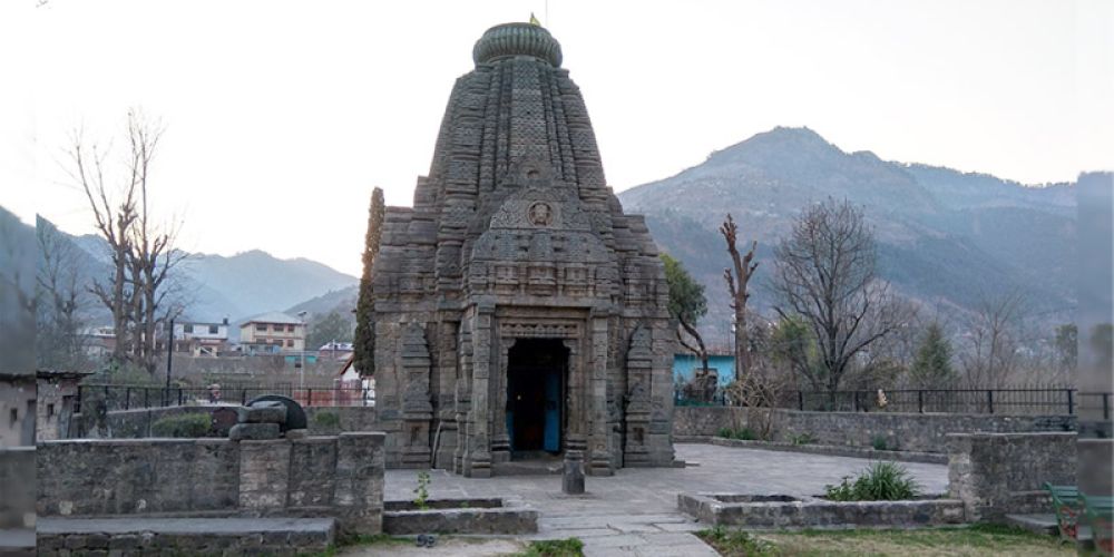
This Shiva temple in Bajaura is constructed entirely of stone in the Shikhara style and is renowned for its intricate sculptures. Archaeologically dated to the early 9th century A.D., local belief holds that it was built by the Pandavas.
Bhuti Weavers Co-operative Society
Established in 1944, this society is renowned for its Kullu shawl industry. Its main office and showroom are located at Bhutti Colony in Shamshi, about 8 km south of Kullu.
Bijli Mahadev Temple
Located at an altitude of 2,435 meters, about 10 km from Kullu, this temple’s staff reaches a height of 60 feet and offers panoramic views of the Kullu valley. It is the highest point around Kullu.
Chaini Kothi

A 35-meter-high tower built in the Kathkuni style, originally as a defensive structure and later used as a temple for a Jogini. It dates back to the 17th century and is located in the Tirthan valley near Banjar.
Dagpo Shedrup Ling Monastery
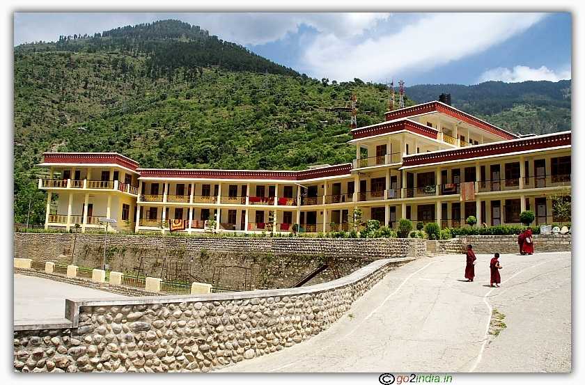
This Tibetan Buddhist monastery of the Gelug school is situated in village Kais, 8 km north of Kullu. Inaugurated in 2005 by the Fourteenth Dalai Lama, it is a continuation of the Dagpo Dratsang monastery from southeastern Tibet.
Dechen Choekhor Monastery

Located in village Sarabhai, 13 km south of Kullu, this Tibetan Buddhist monastery of the Drukpa Kagyu school was constructed between 2000 and 2017. It continues the legacy of a monastery in Tibet destroyed during the Cultural Revolution.
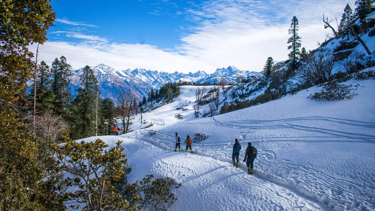
Great Himalayan National Park (GHNP)
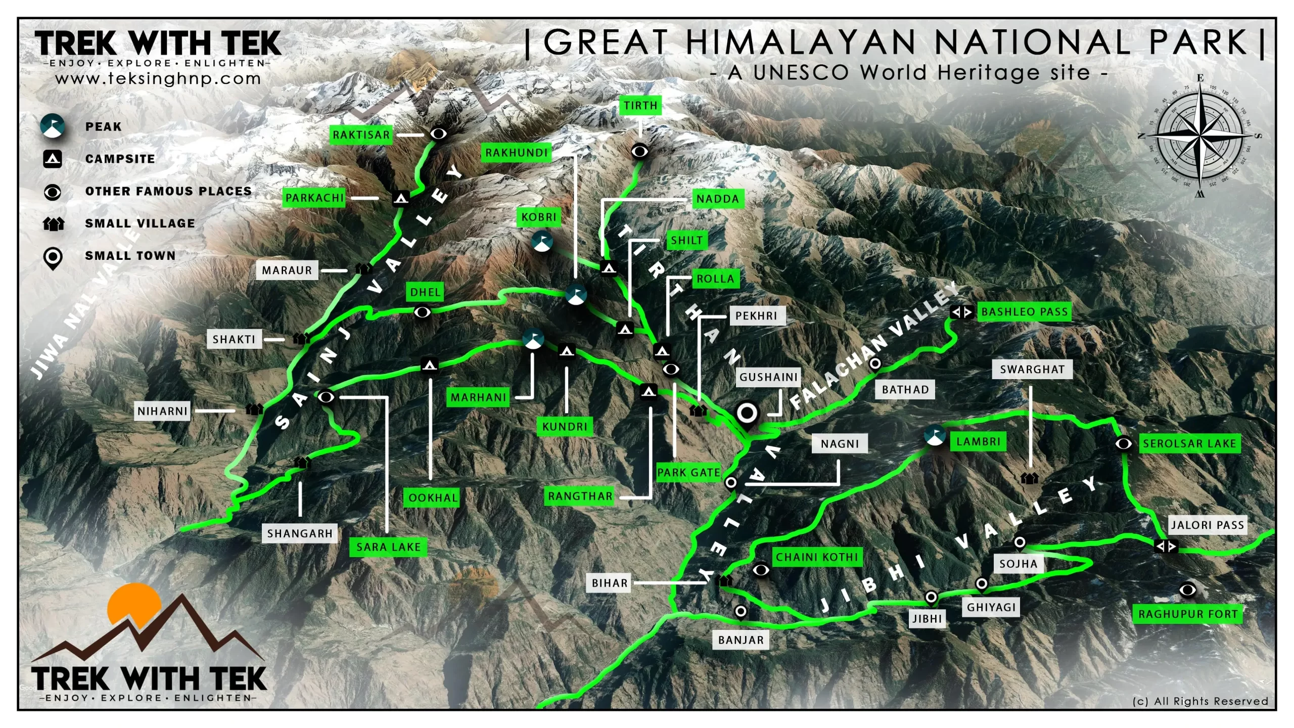
Spanning 700 km² in the Banjar sub-division of Kullu District, this park is drained by the Sainj, Tirthan, Jiwa Nala, and Parvati rivers. Home to various rare species of birds, mammals, insects, and plants, it was established in 1984 and became a UNESCO World Heritage Site in 2014. Entry requires permits.
Khirganga National Park
Established in 2010, Khirganga National Park covers 710 km² at an altitude of 550 meters. It hosts a diverse range of flora and fauna.
Inderkilla National Park

Established in 2010, this park covers approximately 104 km² and is home to over 250 bird species, as well as animals like leopards, brown bears, black bears, and mountain goats.
Hadimba Temple

Situated in the Dungri forest above Manali, this pagoda-style temple, built by Raja Bahadur Singh in 1553 A.D., houses the footprints of Hadimba Devi on a rock inside.
Kais Dhar
Known for its grass meadows and densely forested mountains, Kais Dhar is part of a trekking route and remains roadless to preserve its natural environment. It also features a British-era forest rest house.
Kasol
A village in the Parvati valley, Kasol is popular among backpackers and is known as ‘Little Israel’ for its popularity among young Israeli tourists.
Khanag
Located in Anni tehsil, Khanag features an old rest house with a memorial to English travel writer Penelope Chetwode, who passed away in this remote part of Kullu in 1986. She is known for her book “Kulu: the End of the Habitable World.”
Khokhan
A 14th-century pagoda-style temple dedicated to Adi Brahma is located in Khokhan village, about 10 km south of Kullu. The village offers views of the confluence of the Parvati and Beas rivers, and the Kullu airport.
Lug Valley
This valley has been a site for timber extraction by forest contractors for the last 150 years.
Maha Devi Tirth Temple
Located about 2 kilometers north of Kullu on the Kullu-Manali highway, this temple, also known as Vaishno Devi Mandir, was built in 1966.
Malana
A secluded village known for its unique cultural features, Malana has a distinct language, worship practices, and local self-governance system. It is more connected to the outside world than in the 1950s when Colin Rosser first researched it.
Manali
A famous tourist destination in the Kullu valley, Manali includes Mall Road, Hadimba Temple, Tibetan market, and Old Manali. Nearby sites include Solang Valley, Vashisht hot springs, the Atal Bihari Vajpayee Institute of Mountaineering, and the Snow and Avalanche Study Establishment.
Manikaran
A pilgrimage center in the Parvati valley, Manikaran is famous for its hot springs.
Mathasaur
A scenic meadow located at the top of the Lug valley, Mathasaur features a small temple dedicated to Fungni Mata. Reaching the meadow requires a hike.
Naggar
Once the capital of Kullu, Naggar is home to a 15th-century castle now run as a hotel by Himachal Tourism. It also houses Roerich’s Memorial House and the Nicholas Roerich and Svetsolav Roerich Art Gallery. Nicholas Roerich, a famous Russian scholar and artist, lived here from the late 1920s until his death in 1947. Naggar also features several old temples.
Nirmand
One of the largest villages in Himachal Pradesh, Nirmand is known for its ancient temples, including one dedicated to Parshurama. It is mentioned in the Nirmand Copper Plate from the 7th century A.D.
Raghunath Temple
Built in 1651 A.D. by Raja Jagat Singh of Kullu to house an image of Lord Raghunath (Lord Ram), this temple is highly revered. The Dussehra festival is celebrated here with local deities in honor of Lord Raghunath.
Rohtang Pass

Connecting the Kullu valley with Lahul and Spiti, Rohtang Pass is situated at 3,978 meters, 51 km from Manali. The Atal Tunnel, inaugurated in 2020, bypasses the pass, reducing travel distance. The pass remains a popular tourist spot, with permits required for visiting.
Rupi Palace
Located in Sultanpur, Kullu, this palace was originally built in 1660 A.D. by Raja Jagat Singh and was rebuilt after being damaged in the 1905 Kangra earthquake. It is the residence of Kullu’s royal family descendants.
Shoja
At an altitude of 2,368 meters, Shoja offers panoramic views of the Himalayan ranges. Nearby attractions include Jalori Pass, Jibhi, Serolsar Lake, Raghupur Fort, and Tirthan Valley.
Shringi Rishi Temple
Located in the Banjar valley, about 60 km from Kullu, this temple is dedicated to Shringi Rishi, the ruling deity of the valley. Shringi Rishi is one of the eighteen chief deities of the Kullu valley.
Shrikhand Mahadev
One of the Five Kailash Peaks, Shrikhand Mahadev is considered an abode of Lord Shiva and Goddess Parvati.
Tirthan WLS
A Wildlife Sanctuary in the Banjar subdivision, Tirthan WLS offers diverse flora and fauna species.
- Kullu is a district in which Indian state?
A) Uttarakhand
B) Himachal Pradesh
C) Punjab
D) Jammu and Kashmir - Which district borders Kullu to the south?
A) Mandi
B) Kangra
C) Shimla
D) Kinnaur - Which district lies to the west of Kullu?
A) Lahaul and Spiti
B) Kinnaur
C) Shimla
D) Mandi and Kangra - Which river’s course does the Kullu Valley follow?
A) Yamuna
B) Sutlej
C) Ravi
D) Beas - What is the lowest elevation point in the Kullu Valley?
A) 1,200 meters
B) 833 meters
C) 2,000 meters
D) 3,330 meters - At what elevation is the Atal Tunnel South Portal located?
A) 2,000 meters
B) 3,000 meters
C) 3,330 meters
D) 4,000 meters - Which town serves as the administrative headquarters of Kullu District?
A) Manali
B) Banjar
C) Kullu
D) Mandi - Which riverine tributary of the Beas is NOT mentioned as part of Kullu District?
A) Parvati
B) Sainj
C) Tirthan
D) Sutlej - What is the primary economic activity in Kullu District?
A) Mining
B) Manufacturing
C) Horticulture
D) Fishing - Which national park in Kullu District was created in 1984?
A) Khirganga National Park
B) Great Himalayan National Park
C) Inderkilla National Park
D) Tirthan WLS - What is the height of Rohtang Pass above sea level?
A) 3,978 meters
B) 2,500 meters
C) 4,500 meters
D) 5,000 meters - Which temple is located at Bajaura and is renowned for its intricate sculpture art?
A) Bijli Mahadev Temple
B) Hadimba Temple
C) Basheshwar Mahadev Temple
D) Shringi Rishi Temple - In which valley is the Chaini Kothi located?
A) Parvati Valley
B) Sainj Valley
C) Tirthan Valley
D) Banjar Valley - Which Tibetan Buddhist monastery in Kullu was inaugurated by the Fourteenth Dalai Lama in 2005?
A) Dechen Choekhor Monastery
B) Dagpo Shedrup Ling Monastery
C) Roerich’s Memorial House
D) Hadimba Temple - Where is the Great Himalayan National Park located?
A) Manali Subdivision
B) Banjar Subdivision
C) Anni Subdivision
D) Kullu Town - Which village is known for being very popular among young Israeli tourists and is often called ‘Little Israel’?
A) Kasol
B) Manikaran
C) Malana
D) Shoja - What is the significance of the Raghunath Temple in Kullu?
A) It was built to honor Lord Shiva.
B) It houses the image of Lord Raghunath.
C) It is famous for its hot springs.
D) It is dedicated to Goddess Parvati. - What is the elevation of Shoja?
A) 1,200 meters
B) 2,368 meters
C) 3,000 meters
D) 4,000 meters - Which village in Kullu has a memorial to the English travel writer Penelope Chetwode?
A) Khanag
B) Nirmand
C) Khokhan
D) Kais - What is the primary purpose of the Atal Tunnel?
A) It connects Kullu with Lahaul and Spiti directly.
B) It serves as a tourist attraction.
C) It is a research facility.
D) It is used for military purposes.
Answer Key
- B) Himachal Pradesh
- C) Shimla
- D) Mandi and Kangra
- D) Beas
- B) 833 meters
- C) 3,330 meters
- C) Kullu
- D) Sutlej
- C) Horticulture
- B) Great Himalayan National Park
- A) 3,978 meters
- C) Basheshwar Mahadev Temple
- C) Tirthan Valley
- B) Dagpo Shedrup Ling Monastery
- B) Banjar Subdivision
- A) Kasol
- B) It houses the image of Lord Raghunath.
- B) 2,368 meters
- A) Khanag
- A) It connects Kullu with Lahaul and Spiti directly.
Tougher MCQs
Which year was the Great Himalayan National Park designated as a UNESCO World Heritage Site?
A) 1994
B) 2000
C) 2014
D) 2019What is the historical significance of the Basheshwar Mahadev Temple in Bajaura?
A) Built during the Mughal era
B) Dated to the early 9th century A.D.
C) Constructed by the British
D) Part of a medieval fortressWhich of the following is true about the Dagpo Shedrup Ling Monastery?
A) It was established in 1990.
B) It was inaugurated by the Sixteenth Dalai Lama.
C) It was relocated from southeastern Tibet.
D) It is a monastery of the Kagyu school.What was the original purpose of the Chaini Kothi?
A) A royal palace
B) A defensive structure
C) A marketplace
D) A pilgrimage siteWhich area is known for timber extraction that has been ongoing for 150 years?
A) Lug Valley
B) Parvati Valley
C) Shoja
D) Tirthan ValleyWhich temple’s architecture is known as pagoda-style and is associated with the Hadimba Devi?
A) Raghunath Temple
B) Basheshwar Mahadev Temple
C) Hadimba Temple
D) Bijli Mahadev TempleIn which valley is the Mathasaur scenic meadow located?
A) Tirthan Valley
B) Banjar Valley
C) Lug Valley
D) Sainj ValleyWhat is the primary characteristic of the Dechen Choekhor Monastery’s construction?
A) Built in the 15th century
B) Established in 2000 and completed in 2017
C) Located in the Tirthan Valley
D) Built by the Gelug schoolWhich village in Kullu has a memorial dedicated to the writer Penelope Chetwode?
A) Khokhan
B) Khanag
C) Manikaran
D) KasolWhat unique feature does Malana have compared to other villages in the Kullu valley?
A) A different language and complex local governance system
B) Large-scale tourism infrastructure
C) A famous hot spring
D) An ancient Buddhist monasteryWhich park was established in 2010 and is known for its variety of flora and fauna?
A) Great Himalayan National Park
B) Khirganga National Park
C) Inderkilla National Park
D) Tirthan WLSWhich pass is situated at an elevation of 3,978 meters and connects Kullu with Lahaul and Spiti?
A) Jalori Pass
B) Rohtang Pass
C) Atal Pass
D) Hampta PassWhat significant event is associated with the Raghunath Temple’s history?
A) Constructed to honor Lord Shiva
B) Built to atone for Raja Jagat Singh’s mistake
C) Founded during the Mughal era
D) Dedicated to Goddess ParvatiWhat year was the Inderkilla National Park established?
A) 1990
B) 2000
C) 2010
D) 2015Which village is famous for its “Little Israel” nickname due to its popularity among Israeli tourists?
A) Kasol
B) Malana
C) Shoja
D) NirmandWhat was the original function of the Rupi Palace in Sultanpur?
A) A royal residence
B) A military fort
C) A temple
D) A marketplaceWhat architectural style is the Chaini Kothi known for?
A) Kathkuni
B) Shikhara
C) Pagoda
D) GothicWhat year was the Hadimba Temple built?
A) 1553 A.D.
B) 1600 A.D.
C) 1700 A.D.
D) 1800 A.D.Which area has a forest rest house built during the British era?
A) Kasol
B) Shoja
C) Manikaran
D) NirmandWhich of the following is true about the Khirganga National Park?
A) Established in 2000
B) Spans an area of 500 km²
C) Known for its hot springs
D) Established in 2010
Here are the answers to the tougher MCQs:
C) 2014
(The Great Himalayan National Park was designated as a UNESCO World Heritage Site in 2014.)B) Dated to the early 9th century A.D.
(The Basheshwar Mahadev Temple is dated to around the early 9th century A.D.)C) It was relocated from southeastern Tibet.
(Dagpo Shedrup Ling Monastery was relocated from southeastern Tibet and was inaugurated by the Fourteenth Dalai Lama.)B) A defensive structure
(The Chaini Kothi was originally built as a defensive structure.)A) Lug Valley
(Lug Valley is known for timber extraction that has been ongoing for 150 years.)C) Hadimba Temple
(The Hadimba Temple is known for its pagoda-style architecture.)C) Lug Valley
(Mathasaur is located in the Lug Valley.)B) Established in 2000 and completed in 2017
(The Dechen Choekhor Monastery’s construction started in 2000 and was completed in 2017.)B) Khanag
(Khanag has a memorial dedicated to the writer Penelope Chetwode.)A) A different language and complex local governance system
(Malana is known for its unique language and complex local governance system.)B) Khirganga National Park
(Khirganga National Park was established in 2010 and is known for its variety of flora and fauna.)B) Rohtang Pass
(Rohtang Pass is situated at an elevation of 3,978 meters and connects Kullu with Lahaul and Spiti.)B) Built to atone for Raja Jagat Singh’s mistake
(The Raghunath Temple was built by Raja Jagat Singh to atone for his mistake.)C) 2010
(Inderkilla National Park was established in 2010.)A) Kasol
(Kasol is known as “Little Israel” due to its popularity among Israeli tourists.)A) A royal residence
(The Rupi Palace was originally built as a royal residence.)A) Kathkuni
(The Chaini Kothi is known for its Kathkuni architectural style.)A) 1553 A.D.
(The Hadimba Temple was built in 1553 A.D.)B) Shoja
(Shoja has a British-era forest rest house.)D) Established in 2010
(Khirganga National Park was established in 2010.)