Passes of Himachal Pradesh
Disclaimer:
Passes of Himachal Pradesh: Passes (also called mountain passes) are natural routes or gaps through mountain ranges that allow people to travel from one side to the other. They are usually lower in elevation compared to the surrounding peaks, making it easier to cross the mountains. Passes can be used for roads, trails, or even railways. They often provide breathtaking views and are crucial for connecting different regions, especially in mountainous areas.

Himalayan Passes in Himachal Pradesh and Surrounding Regions
Northern Himachal Pradesh
1. Baralacha La Pass
o Location: Zanskar Range
o Connects: Lahaul district to Leh district
o Region: Northern India
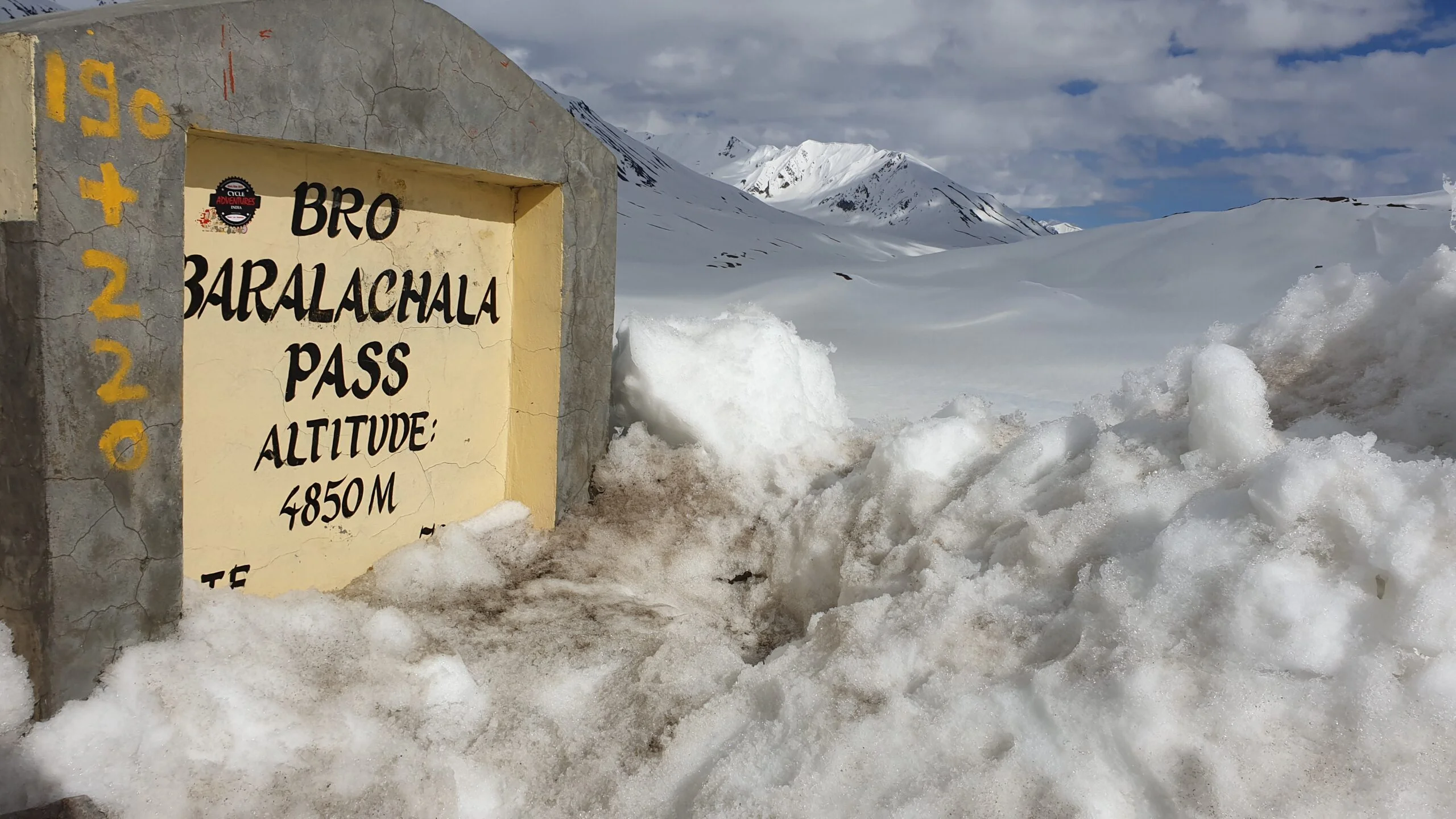
Description: Bara Lacha La is a high mountain pass situated in the Himalayas. It serves as a vital connection between Himachal Pradesh and Ladakh, offering stunning views and challenging terrain.
2. Bhaba Pass
o Also Known As: Bhawa Pass
o Location: Border of Kinnaur and Lahaul & Spiti districts
o Notable Features: Borders Pin Valley National Park and Rupi-Bhaba Wildlife Sanctuary
3. Debsa Pass
o Altitude: 5,360 meters
o Location: Between Kullu and Spiti Districts
4. Jot Pass
o Altitude: Approx. 4,200 meters
o Location: Pathankot-Nurpur-Chowari-Chamba stretch
o Notable Features: One of the highest altitude tourist destinations in Chamba
5. Rupin Pass
o Altitude: 4,650 meters
o Location: Between Dhaula (Uttarakhand) and Sangla (Himachal Pradesh)
o Notable Features: Traditional shepherd and hiking route
6. Shingo La
o Altitude: 5,091 meters
o Location: Border between Ladakh and Himachal Pradesh
o Connects: Lahaul region to Zanskar region
o Notable Features: Nimmu-Padum-Darcha road runs over the pass; Shingo La Tunnel planned
Central Himachal Pradesh
7. Chanshal Pass
o Altitude: 4,520 meters
o Location: Shimla district
o Connects: Dodra Kwar and Rohru
8. Hamta Pass
o Location: Between Chandra Valley (Lahaul) and Kullu Valley
o Named After: Hamta Village
9. Indrahar Pass
o Altitude: 4,342 meters
o Location: Dhauladhar range
o Connects: Kangra and Chamba districts
Description: Inderhaar Pass is located in the Dhauladhar range of the Himalayas at the height of 4342 meters from sea level, and this is a border pass between Kangra and Chamba districts. The trekking trail to Indrahar pass starts from Galu Devi temple above Dharamkot village near Dharamsala and passes through the camping ground of Triund, Ilaqua/Laka Got, and Lahesh Caves. On the other side of the pass, the camping sites include Chhata caves at 3242 meters and Kuarsi village in Chamba at 2,260 meters.
10.Chanderkhani Pass
o Altitude: 3,650 meters
o Location: Kullu district
o Connects: Kullu and Parvati valleys
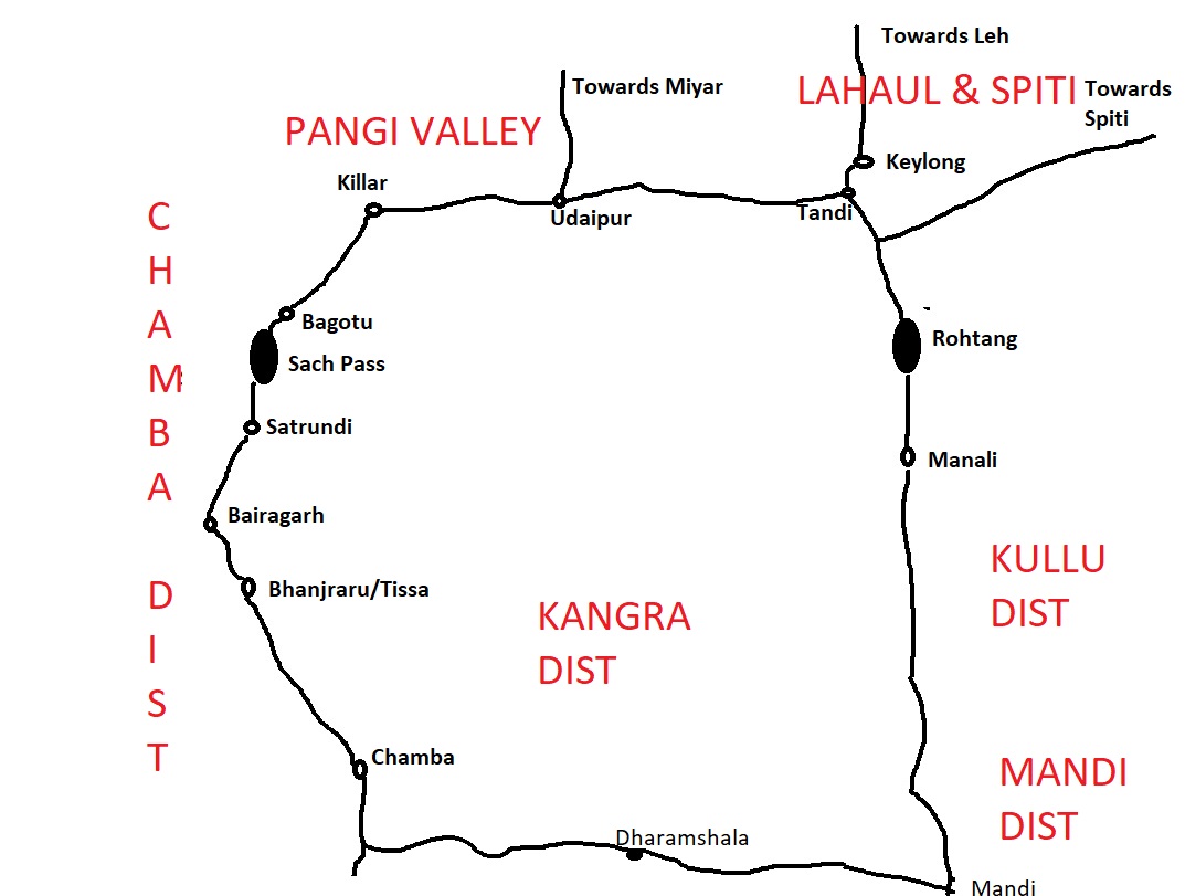
11. Sacha Pass
o Altitude: 4,414 meters
o Location: Chamba District
o Connects: Chamba Valley and Pangi Valley
Description: Saach Pass connects the Chamba Valley with the Pangi Valley. Located in the Pir Panjal Range, it is 127 kilometers from the district headquarters and provides the shortest route to Killar.
12. Pin Parbati Pass
o Connects: Parvati Valley (Kullu) with Pin Valley (Lahaul and Spiti)
Southern Himachal Pradesh
13. Jalori Pass
o Altitude: Approx. 3,135 meters
o Location: Southern Himachal Pradesh
Description: Jalori Pass is a scenic pass that provides the only gateway from Inner Seraj to Outer Seraj. Located on the Kullu-Rampur Road, it is known for its adventurous, isolated road and attractive views. The nearby Siyolsar Lake is a notable attraction.
14. Minkiani Pass
o Altitude: 4,300 meters
o Location: Dhauladhar ranges, near Kareri Lake
15. Nalgan Pass
o Altitude: 4,978 meters
o Location: Between Garhwal and Himachal Himalayas
16. Tingloti Pass
o Altitude: 4,761 meters
o Location: Chamba district
17. Gaj Pass
o Location: Dhauladhar Range
o Notable Features: Shortest route to Lam Dal Lake
18. Padri Pass
o Altitude: 3,037 meters
o Location: 41 km North of Bhaderwah
o Notable Features: Used for snow-skiing and paragliding
Other Notable Passes
19. Borasu Pass
o Also Known As: Bara-su
o Location: Border of Uttarakhand and Himachal Pradesh
o Connects: Har Ki Doon valley and Kinnaur valley
20. Parang La Pass
o Altitude: 5,580 meters
o Connects: Spiti and Ladakh regions
o Notable Features: Ancient trade route
21. Takling La
o Altitude: 5,575 meters
o Location: Spiti Valley
o Connects: Kaza to Karzok
22. Shipki La
o Altitude: 4,720 meters
o Location: India-China border
o Notable Features: Border post with significant buildings
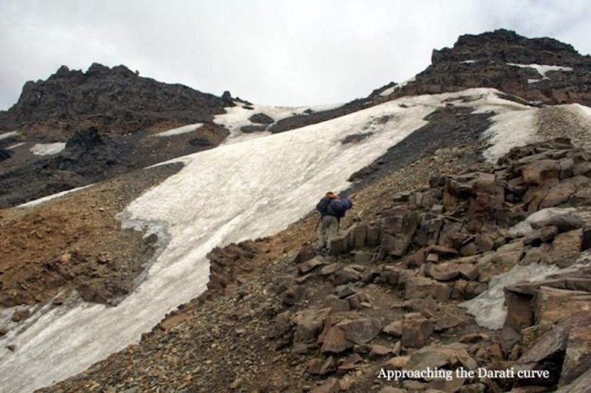
23. Darati Pass
o Altitude: 4,700 meters
o Location: Pir Panjal range
o Connects: Churah Valley to Tindi Valley
24. Makori Jot
o Location: Kangra, Himachal Pradesh
o Coordinates: 32° 12′ 17″ N, 76° 54′ 28″ E
25.Talang Pass
- Altitude: 4,640 meters
- Location: Dhauladhar Range, Kangra District, Himachal Pradesh
- Description: Named after the local deity Telong, Talang Pass is one of the highest and most challenging passes in the Dhauladhar range. Its complex terrain makes it infrequently used by shepherds and trekkers.
This arrangement categorizes the passes based on their geographic regions and notable features for easier reference.
Here’s the refined list of famous passes and jots in Himachal Pradesh, categorized by district more than 55+ Passes and Jots Of Himachal Pradesh
Kullu District:
Jalori Pass
- Altitude: 3,135 meters
- Location: Inner & Outer Seraj, Kullu
Rashol Jot
- Altitude: 3,230 meters
- Location: Kullu
Pajanund Galu
- Altitude: 3,280 meters
- Location: Mandi – Kullu
Khauli Galu
- Altitude: 3,440 meters
- Location: Kullu
Jalsu Ka Jot
- Altitude: 3,450 meters
- Location: Kangra – Kullu
Chanderkhani Galu
- Altitude: 3,600 meters
- Location: Kullu
Tainti Galu
- Altitude: 3,600 meters
- Location: Kullu
Gharhu Jot
- Altitude: 3,735 meters
- Location: Kullu
Sari Galu
- Altitude: 3,745 meters
- Location: Kullu – Kangra
Animal Pass
- Altitude: 4,880 meters
- Location: Kullu
Manali Pass
- Altitude: 4,880 meters
- Location: Manali – Kangra
Kathi Kukri
- Altitude: 4,645 meters
- Location: Kullu – Kangra
Taintu Ka Jot
- Altitude: 5,050 meters
- Location: Kullu – Kangra
Sara Umga Pass
- Altitude: 5,010 meters
- Location: Kullu – Spiti
Chamba District:
Padri Pass
- Altitude: 3,050 meters
- Location: Chamba – Jammu
Chauri
- Altitude: 3,150 meters
- Location: Chamba – Kangra
Jalsu Ka Jot
- Altitude: 3,450 meters
image from harsh guleria - Location: Kangra – Chamba
Baleni Jot
- Altitude: 3,730 meters
- Location: Kangra – Chamba
Sach Pass
- Altitude: 4,395 meters
- Location: Chamba – Pangi
Drati Pass
- Altitude: 4,720 meters
- Location: Chamba – Pangi
Khidala Galu
- Altitude: 4,750 meters
- Location: Chamba
Talang Pass
- Altitude: 4,640 meters
- Location: Kangra – Chamba
Borsa Pass
- Altitude: 5,360 meters
- Location: Kinnaur – Garhwal

Lahaul District:
Rohtang Pass
- Altitude: 3,978 meters
- Location: Kullu – Lahaul
Ranjcha Pass
- Altitude: 4,400 meters
- Location: Lahaul – Spiti
Shipkila
- Altitude: 4,500 meters
- Location: The Shipki La Pass, located in the Himalayan Range in Himachal Pradesh, India, connects the Kinnaur district in India with the Ngari Prefecture in Tibet, China.
Kunzum Pass
- Altitude: 4,520 meters
- Location: Lahaul – Spiti
- Description: Kunjum Pass is a high mountain pass that connects Lahaul Valley with Spiti Valley. It is situated along the Gramphoo-Kaza-Sumdo Road, providing a crucial link between these two regions
Tempo La
- Altitude: 4,930 meters
- Location: Lahaul – Spiti
Chabia Pass
- Altitude: 4,934 meters
- Location: Pangi Range, Lahaul, Bharmaur
Mulari Jot
- Altitude: 4,960 meters
- Location: Lahaul
Kugti Pass
- Altitude: 4,961 meters
- Location: Lahaul – Bharmaur
Shipting
- Altitude: 4,980 meters
- Location: Bharmaur – Lahaul
Baralacha La
- Altitude: 4,890 meters
- Location: Pangi Range, Lahaul, Bharmaur
Shakarof
- Altitude: 5,025 meters
- Location: Lahaul – Spiti
Laluni Jot
- Altitude: 5,440 meters
- Location: Lahaul – Spiti
Kangra District:
Jalsu Ka Jot
- Altitude: 3,450 meters
- Location: Kangra – Chamba
Tamsar Pass
- Altitude: 4,572 meters
- Location: Kangra – Bara Banghal (Dhauladhar Range)
Singoor Pass
- Altitude: 4,310 meters
- Location: Kangra – Bharmaur
Indrahar Pass
- Altitude: 4,320 meters
- Location: Kangra – Bharmaur
Tori Jot
- Altitude: 4,360 meters
- Location: Kangra – Chamba
Nikora Pass
- Altitude: 4,755 meters
- Location: Kangra – Bharmaur
Asha Gali
- Altitude: 5,030 meters
- Location: Kangra – Lahaul – Spiti
Kamilaga Pass
- Altitude: 5,151 meters
- Location: Kinnaur – Garhwal
Makori Jot
- Altitude: 5,190 meters
- Location: Kangra
Kinnaur District:
Shibaling Pass
- Altitude: 3,980 meters
- Location: Kinnaur
Shinka Pass
- Altitude: 4,575 meters
- Location: Kinnaur – Garhwal
Burua Pass
- Altitude: 4,578 meters
- Location: Kinnaur – Garhwal
Rupin Ghati
- Altitude: 4,625 meters
- Location: Kinnaur – Garhwal
- Rupin Pass is a high altitude pass across the Himalaya mountain range in state of Himachal pradesh India. It lies on a traditional shepherd and hiking route which starts from Dhaula in Uttarakhand and ends in Sangla in Himachal Pradesh.
Nalgaon Pass
- Altitude: 5,035 meters
- Location: Kinnaur – Garhwal
Kamilaga Pass
- Altitude: 5,151 meters
- Location: Kinnaur – Garhwal
Lamkhaga Pass
- Altitude: 5,284 meters
- Location: Kinnaur – Garhwal
- Lamkhaga pass (aka Chitkul to Harsil/Gangotri trek), this 5300m high pass is one of the toughest to trek in the Garhwal Himalayas.
Charang Pass
- Altitude: 5,266 meters
- Location: Kinnaur – Garhwal
Spiti District:
Kunzum Pass
- Altitude: 4,520 meters
- Location: Lahaul – Spiti
Shipkila
- Altitude: 4,500 meters
- Location: Lahaul – Spiti
- Description: Shipki La Pass serves as a border post between India and China. The road through this pass is used for small-scale local trade. Access for non-residents is restricted, similar to other border passes along the India-Tibet border.
Tempo La
- Altitude: 4,930 meters
- Location: Lahaul – Spiti
Chabia Pass
- Altitude: 4,934 meters
- Location: Pangi Range, Lahaul, Bharmaur
Sara Umga Pass
- Altitude: 5,010 meters
- Location: Kullu – Spiti
- Kullu district of Himachal Pradesh
Shakarof
- Altitude: 5,025 meters
- Location: Lahaul – Spiti
Pin Parbati
- Altitude: 5,320 meters
- Location: Kullu – Spiti
- The Pin Parbati Pass is a mountain pass in Himachal Pradesh, India, at 5,319 m. Records show it was first crossed in August 1884 by Sir Louis Dane in search of an alternate route to the Spiti valley, but the shepherds from spiti used to do it often for grazing their sheep in the lush green parvati valley.
Borsa Pass
- Altitude: 5,360 meters
- Location: Kinnaur – Garhwal
Q.1 What is the altitude of the Rohtang Pass?
A. 3,978 meters
B. 4,020 meters
C. 3,600 meters
D. 4,300 meters
Answer: A. 3,978 meters
Explanation: The Rohtang Pass is located at an altitude of 3,978 meters and is a key pass connecting Kullu and Lahaul.
Q.2 Which pass is located between Kullu and Spiti?
A. Shibaling Pass
B. Kunzum Pass
C. Baralacha La
D. Taintu Ka Jot
Answer: B. Kunzum Pass
Explanation: Kunzum Pass, at 4,520 meters, connects Kullu and Spiti districts.
Q.3 The Chauri Pass is situated between which districts?
A. Kullu and Kangra
B. Kullu and Mandi
C. Chamba and Kangra
D. Kangra and Bharmaur
Answer: C. Chamba and Kangra
Explanation: The Chauri Pass is located between the Chamba and Kangra districts.
Q.4 What is the altitude of the Baralacha La Pass?
A. 4,800 meters
B. 4,890 meters
C. 4,500 meters
D. 5,000 meters
Answer: B. 4,890 meters
Explanation: Baralacha La is situated at an altitude of 4,890 meters, located in the Pangi Range and connecting Lahaul with Bharmaur.
Q.5 Which pass has the highest altitude in Himachal Pradesh?
A. Shakarof
B. Borsa Pass
C. Lamkhaga Pass
D. Kamilaga Pass
Answer: C. Lamkhaga Pass
Explanation: Lamkhaga Pass, with an altitude of 5,284 meters, is the highest pass in Himachal Pradesh.
Q.6 The Tainti Galu Pass is located in which district?
A. Kinnaur
B. Kangra
C. Kullu
D. Chamba
Answer: C. Kullu
Explanation: Tainti Galu Pass is located in the Kullu district and has an altitude of 3,600 meters.
Q.7 Which of the following passes is situated between Kullu and Spiti?
A. Shipkila
B. Shinka Pass
C. Pin Parbati
D. Sara Umga Pass
Answer: D. Sara Umga Pass
Explanation: The Sara Umga Pass is located between Kullu and Spiti, with an altitude of 5,010 meters.
Q.8 The Shibaling Pass is found in which district?
A. Kangra
B. Kullu
C. Kinnaur
D. Lahaul
Answer: C. Kinnaur
Explanation: Shibaling Pass, with an altitude of 3,980 meters, is located in Kinnaur.
Q.9 What is the altitude of the Jalsu Ka Jot Pass?
A. 3,450 meters
B. 4,000 meters
C. 3,600 meters
D. 4,200 meters
Answer: A. 3,450 meters
Explanation: The Jalsu Ka Jot Pass is situated at an altitude of 3,450 meters, located between Kangra and Chamba.
Q.10 The Animal Pass is situated in which district?
A. Kullu
B. Chamba
C. Kinnaur
D. Lahaul
Answer: A. Kullu
Explanation: Animal Pass, with an altitude of 4,880 meters, is located in the Kullu district.
Q.11 The Kalicho Pass connects which two regions?
A. Kullu and Spiti
B. Kinnaur and Bharmaur
C. Lahaul and Bharmaur
D. Kinnaur and Garhwal
Answer: C. Lahaul and Bharmaur
Explanation: Kalicho Pass, at 4,730 meters, connects Lahaul and Bharmaur regions.
Q.12 The Padri Pass is located between which two areas? While Bara Lacha La’s challenging terrain demands focus and adaptability from travelers, some find a parallel sense of unpredictability and reward in navigating online pokies Australia for real money platforms.
A. Chamba and Jammu
B. Kangra and Kullu
C. Mandi and Kullu
D. Kullu and Spiti
Answer: A. Chamba and Jammu
Explanation: Padri Pass, at 3,050 meters, connects Chamba with Jammu.
Q.13 Which pass is known for connecting Kangra with Bharmaur?
A. Singoor Pass
B. Indrahar Pass
C. Nikora Pass
D. Tori Jot
Answer: A. Singoor Pass
Explanation: Singoor Pass, at 4,310 meters, connects Kangra with Bharmaur.
Q.14 The Chanderkhani Galu Pass is situated in which district?
A. Chamba
B. Lahaul
C. Kullu
D. Kinnaur
Answer: C. Kullu
Explanation: Chanderkhani Galu Pass, with an altitude of 3,600 meters, is located in the Kullu district.
Q.15 The Rupin Ghati Pass is located between which two regions?
A. Kinnaur and Garhwal
B. Kullu and Kangra
C. Lahaul and Spiti
D. Kinnaur and Lahaul
Answer: A. Kinnaur and Garhwal
Explanation: Rupin Ghati Pass, with an altitude of 4,625 meters, is situated between Kinnaur and Garhwal.
Q.16 Which pass is situated at an altitude of 4,640 meters?
A. Borsa Pass
B. Talang Pass
C. Lamkhaga Pass
D. Kalicho Pass
Answer: B. Talang Pass
Explanation: Talang Pass, with an altitude of 4,640 meters, is located between Kangra and Chamba.
Q.17 The Kunzum Pass connects which two districts?
A. Lahaul and Spiti
B. Kullu and Spiti
C. Kinnaur and Garhwal
D. Kangra and Bharmaur
Answer: A. Lahaul and Spiti
Explanation: Kunzum Pass, at 4,520 meters, connects Lahaul with Spiti.
Q.18 The Burua Pass is located in which district?
A. Chamba
B. Kinnaur
C. Lahaul
D. Kangra
Answer: B. Kinnaur
Explanation: Burua Pass, at 4,578 meters, is located in Kinnaur.
Q.19 The Bherianga Pass is situated between which districts?
A. Kullu and Kangra
B. Chamba and Kullu
C. Kangra and Bharmaur
D. Kullu and Lahaul
Answer: A. Kullu and Kangra
Explanation: Bherianga Pass, at 4,140 meters, connects Kullu with Kangra.
Q.20 What is the altitude of the Shipting Pass?
A. 4,800 meters
B. 4,900 meters
C. 4,980 meters
D. 5,000 meters
Answer: C. 4,980 meters
Explanation: Shipting Pass, with an altitude of 4,980 meters, is located between Bharmaur and Lahaul.
Q.21 Which pass has an altitude of 5,266 meters?
A. Charang Pass
B. Borsa Pass
C. Lamkhaga Pass
D. Shakarof
Answer: A. Charang Pass
Explanation: Charang Pass, with an altitude of 5,266 meters, is located in Kinnaur.