Brief Geography of Solan District: An Overview
Solan District: A Brief Geography

Solan District, located in Himachal Pradesh, is known for its diverse and fascinating geography. This region is celebrated for its natural beauty, historical significance, and cultural heritage. Let’s take a closer look at the geography of Solan District.
Overview of Solan City
Solan is a prominent city in the Indian state of Himachal Pradesh and serves as the district headquarters of Solan District. It is situated approximately 45.5 kilometers (28 miles) south of Shimla, the state capital. The city boasts an average elevation of 1,550 meters (5,090 feet) and is positioned strategically between Chandigarh, the joint capital of Punjab and Haryana, and Shimla, on the Kalka-Shimla National Highway-5. The narrow-gauge Kalka-Shimla Railway, a significant historic line, also passes through Solan. Nestled in the Shivalik hills of the Himalayas, Solan is located near the Punjab-Himachal border.
Historical Significance
Historically, Solan was the capital of the princely state of Baghat. Today, it is renowned for its ancient temples and monasteries. Key religious attractions include:
- Shoolini Mata Temple: Dedicated to the Hindu goddess Shoolini Devi, a manifestation of Goddess Durga in her warrior aspect.
- Jatoli Shiv Temple: A prominent temple in the region.
- Yundung Monastery: One of the famous monasteries in the area.
The city’s name is derived from Shoolini Devi, whose name translates to “the goddess wielding the spear.” An annual fair in June honors the goddess, featuring a three-day mela at the central Thodo ground.
Economic and Cultural Highlights
Solan is distinguished for several reasons:
- Mushroom Production: The city is renowned for its mushroom farming, supported by the Directorate of Mushroom Research (DMR) located in Chambaghat. This has earned Solan the title of “Mushroom City of India.”
- Tomato Production: Due to extensive tomato cultivation, Solan is also referred to as the “City of Red Gold.”
In addition to its agricultural fame, Solan is home to one of the oldest breweries in India and features a 300-year-old fort located on a hilltop, adding to its historical charm and significance.
Read Also: Census of solan District 2011
Key Attractions
- Shoolini Mata Fair: Held annually in June at Thodo Ground, this fair celebrates the local goddess with vibrant festivities.
- Kalka-Shimla Railway: The narrow-gauge railway passing through Solan is a historical landmark and a UNESCO World Heritage Site.
Solan’s strategic location, historical significance, and economic contributions make it a unique and culturally rich city in Himachal Pradesh.
1. Population and Area
- Area: 1,936 sq km
- Population: 580,320
- Languages: Hindi, Pahari
- Villages: 2,614
- Male Population: 308,754
- Female Population: 271,566
2. Location
Solan District is bordered by the following regions:
- North: Shimla District
- South: Ropar District, Punjab
- East: Sirmaur District
- West: Bilaspur District
- Northeast: Mandi District
3. Geographic Structure
The geographic structure of Solan District features diverse landscapes:
- Sutlej Basin
- Solan Lesser Himalayas
- Nalagadh Shiwaliks
- Solan Forests
Geographic Shape and Position:
- Shape: Rectangular, slightly elevated towards the north
- Longitude: 76.42° to 77.20°
- Latitude: 30.05° to 31.15°
- Altitude: Ranges from 300 to 3,000 meters above sea level
4. Valleys
- Doon Valley: The most fertile and largest valley in the region.
- Kunihaar Valley: Small but significant.
- Sapurun Valley: Small, with important geographic features.
5. Geographic Context
Key geographic areas of Solan District:
- Sutlej Basin: Located in the southern part of the district.
- Shiwalik Ranges: Along the district’s borders and hilly regions.
- Nalagadh Shiwaliks: Located near the western border.
- Solan Forests: An important part of the region’s vegetation and forest area.
Solan District’s River System
The district features the catchment areas of three major rivers: Sutlej, Yamuna, and Ghaggar. Each river has its own tributaries, which are significant to the region’s climate and geography.
- Sutlej River
- Source: From the Himalayan hills
- Tributaries: Kyar Nala, Gandhar River, Dadar Khad, Kuthar River
- Yamuna River
- Tributary: Ashni (Ashwani Khad)
- Ghaggar River
- Source: From the hills above Kalka
- Mainstream: In Nalagarh
- Tributaries: Kaushalya, Sirsa River
- Ghambar River
- Type: Rain-fed river
- Tributaries: Right bank tributaries: Dabar, Kuthar, Kohaj; Left bank tributaries: Rao, Kuni, Badhhal Khad
- Sirsa River
- Location: Nalagarh Shiwalik region
- Tributaries: Balad River, Ralla River, Phula Nala, Chikni Khad
Solan District Headquarters
Location and Elevation:
- Location: Solan, Himachal Pradesh
- Elevation: 1,600 meters (5,200 feet)
- Distance from State Capital: 46 kilometers south of Shimla
History and Significance:
- Establishment: Solan District was created on September 1, 1972.
- Naming: The district is named after the Hindu goddess Shoolini Devi.
- Former Capital: Solan was the capital of the erstwhile princely state of Baghat.
Features:
- Mushroom Production: Solan is known as “The Mushroom City of India” due to its extensive mushroom cultivation, with the Mushroom Research Directorate (DMR) in Chambaghat being a key reason.
- Tomato Production: Solan is referred to as “The Red Gold City” because of its large-scale tomato cultivation.
Attractions:
- Festivals: A three-day fair is held every June at Thodo Ground to celebrate the Shoolini Devi festival.
- Railway Line: The Kalka-Shimla Narrow Gauge Heritage Railway Line, passing through Solan, is recognized as a World Heritage Site.
Geographic Position:
- Road Access: Solan is situated on the Kalka-Shimla National Highway between Chandigarh and Shimla.
The geography of Solan District not only highlights its natural beauty but also emphasizes its historical and cultural significance.
Geography and Climate of Solan
Geographic Location
Solan is situated at coordinates 30.92°N and 77.12°E, with an average elevation of 1,502 meters (5,249 feet). The highest point in the area is Mount Karol, which reaches 2,280 meters. Notably, the mountaintop features Pandava’s Cave, a site believed to have been used by the Pandavas for meditation during their 12-year exile. The city experiences occasional snowfall during winter months.
Solan serves as a base station for exploring nearby tourist destinations such as Chail, Dagshai, Sabathu, Kandaghat, Kasauli, Rajgarh, Salogra, and Churdhar Peak.
Climate
Solan, located at an average altitude of 1,600 meters, offers a moderate hill station climate. The city is neither as cold as Shimla nor as warm as Kalka, with temperatures rarely exceeding 35°C (95°F). This makes Solan an attractive location for residential purposes. The city experiences light snowfall in winter, and temperatures range from −4°C (25°F) to 34°C (93°F) throughout the year, with a record high temperature of 39°C (102.2°F).
Summary
Solan’s climate is characterized by moderate temperatures and moderate to high humidity, with a mix of seasonal variations including light snowfall in winter. The city’s location within the Shivalik hills and its proximity to various tourist spots make it an attractive destination for both residents and visitors.
Flora, Fauna, and Tourist Attractions of Solan
Flora and Fauna
Flora: Solan’s vegetation is diverse due to its varied elevation and climatic conditions. The region features a mix of indigenous and ornamental plants:
- Indigenous Vegetation: The predominant trees include deodar cedar, pine, and oak. Oak forests are particularly found at higher elevations and in moist areas. Chail, a nearby area, is noted for its rich plant species.
- Ornamental and Alien Plants: The area also has non-native plants such as silver oak, jacaranda, bottle brush, weeping willows, and kachnar. Grasses and other ornamental plants add to the region’s botanical diversity.
Fauna: The animal life in Solan is influenced by its varied terrain and altitude:
- Carnivores: Himalayan black bears, leopards, and panthers are among the predatory species found in the region.
- Herbivores: Common herbivores include the ghoral (a type of goat) and barking deer. Other animals include jackals, mongooses, wild cats (jangli billi), monkeys, and langurs.
- Game Birds: The region hosts various game birds like the jungle fowl, pigeons, grey partridge, and kolsa.
Tourist Attractions
Solan offers a range of attractions for visitors:
- Religious Sites:
- Maa Shoolini Devi Temple: Located on Shilly Road, this temple is dedicated to the local deity Shoolini Devi.
- Jatoli Shiv Temple: Situated on Rajgarh Road, this temple is known for its serene environment.
- Bon Monastery, Dolanji: Located approximately 3 km from Oachghat, this monastery is significant for its Tibetan Buddhist traditions.
- Parks and Recreation:
- Jawahar Park: Positioned on a hilltop, offering panoramic views of the town.
- Children’s Park: Located on Mall Road, it features animal rides and a musical fountain.
- Mohan Park: Built by Mohan Meakin Breweries, it includes a terrace garden and recreational rides.
- Subhash Chandra Bose Park: Located on Hospital Road, it provides green space and amenities.
- Historical and Cultural Sites:
- Mohan Shakti National Heritage Park: Spanning 40 acres, this park features temples, meditation centers, theme parks, herbal plantations, and a research center focused on Indian heritage and philosophy.
- Kasauli Hill Station: A nearby destination with a colonial charm, pine-covered hills, and historical sites including the Central Research Institute (CRI), which is the oldest in India.
- Other Attractions:
- Yogananda Library: An internationally awarded library at Shoolini University, located 20 minutes away from Solan.
- Mohan Meakin Breweries: Known as the oldest distillery in India, it offers a glimpse into the region’s brewing history.
- Toy Train and Solan Railway Station: Part of the UNESCO World Heritage site on the Kalka-Shimla narrow gauge railway.
- Barog Railway Station: Features the longest tunnel on the Kalka-Shimla railway line and is known for its scenic surroundings.
- Recreational Areas:
- Thodo Ground: A central venue for cultural events, sports activities, and official functions.
- Police Ground: An upcoming ground with potential for stadium development and current use as a training ground for local police.
- Radhaswami Satsang (RRSB) Ground: A large open area at Anji for community and religious events.
Tourism Infrastructure: Solan is rapidly developing as a tourist destination with numerous hotels catering to various budgets. The town serves as a reference station for tourists visiting nearby places like Chail, Kasauli, Dagshai, Sabathu, and Churdhar Peak. A tourist information office is available, and there are plans to introduce minibuses for sightseeing tours.
Solan’s combination of natural beauty, historical sites, and diverse flora and fauna makes it an appealing destination for both relaxation and exploration.
Famous Temples of Solan District
1. Shoolini Mata Temple
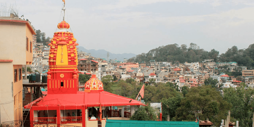
- Location: Shilly Road, Solan.
- Description: Dedicated to Goddess Shoolini, an incarnation of Goddess Durga, this temple is a significant religious site in Solan. The annual Shoolini Fair held in June attracts thousands of devotees. The festival celebrates the goddess and includes traditional festivities and cultural events.
- Significance: The temple is a central place of worship for locals and is renowned for its vibrant fairs and festivals.
2. Jatoli Shiv Temple
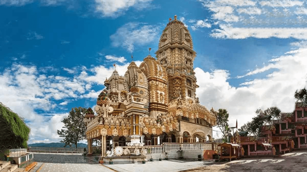
- Location: Rajgarh Road, Solan.
- Description: This temple is dedicated to Lord Shiva and is situated at a higher elevation, offering panoramic views of the surrounding area. It is one of the highest temples in Himachal Pradesh.
- Significance: The temple is an important pilgrimage site, known for its serene atmosphere and spiritual significance.
3. Bon Monastery (Dolanji Bon Monastery)

- Location: Approximately 3 km from Oachghat, Solan.
- Description: The Bon Monastery is dedicated to the Bon religion, which is an ancient Tibetan spiritual tradition. It features traditional Tibetan architecture and is a center for Bon practitioners.
- Significance: It is a unique religious site in the region, offering insights into Tibetan culture and spirituality.
4. Sidh Baba Ka Mandir

- Location: Near Solan.
- Description: Dedicated to Sidh Baba, this temple is a popular site for devotees who come to seek blessings and peace.
- Significance: The temple is known for its serene atmosphere and is a place of spiritual solace for many.
Overview of Temples in Solan
- Religious Significance: These temples are important pilgrimage sites for both locals and visitors, reflecting the spiritual and cultural heritage of the region.
- Cultural Events: Many temples, especially the Shoolini Mata Temple, host annual fairs and festivals that are significant cultural events in Solan.
- Architectural Style: The temples exhibit traditional Himalayan architecture and are often situated in picturesque locations, offering beautiful views and a tranquil environment.
These temples contribute significantly to Solan’s cultural and spiritual landscape, attracting visitors who wish to explore the region’s religious traditions and natural beauty.
Also Read This:
- Glaciers in Himachal Pradesh
- Brief Geography of Kullu District
- Brief Geography of Mandi District
- Brief Geography of Lahaul-Spiti
- River System in Himachal Pradesh
- Brief Geography of Kinnaur District
- Geography of Chamba
- What is the average elevation of Solan city?
- A) 1,200 meters
- B) 1,500 meters
- C) 1,550 meters
- D) 1,800 meters
- Which river system does not flow through Solan District?
- A) Sutlej
- B) Yamuna
- C) Ganges
- D) Ghaggar
- Solan is located approximately how many kilometers south of Shimla?
- A) 30 kilometers
- B) 45.5 kilometers
- C) 60 kilometers
- D) 75 kilometers
- Which historic railway line passes through Solan?
- A) Kalka-Shimla Narrow Gauge Railway
- B) Delhi-Agra Railway
- C) Mumbai-Delhi Express
- D) Kolkata-Bangalore Line
- Which temple in Solan is dedicated to Goddess Shoolini?
- A) Jatoli Shiv Temple
- B) Shoolini Mata Temple
- C) Bon Monastery
- D) Sidh Baba Ka Mandir
- Which city is known as the ‘Mushroom City of India’?
- A) Shimla
- B) Kullu
- C) Solan
- D) Mandi
- What is the primary language spoken in Solan District?
- A) Punjabi
- B) Hindi
- C) English
- D) Tibetan
- Which valley is the largest and most fertile in Solan District?
- A) Sapurun Valley
- B) Kunihaar Valley
- C) Doon Valley
- D) Junga Valley
- Which river is a tributary of the Yamuna River in Solan District?
- A) Ghaggar
- B) Kyar Nala
- C) Ashni (Ashwani Khad)
- D) Sirsa River
- Solan District’s geographic shape can be described as:
- A) Circular
- B) Triangular
- C) Rectangular
- D) Oval
- Which temple is known for its serene environment and is situated on Rajgarh Road?
- A) Shoolini Mata Temple
- B) Bon Monastery
- C) Jatoli Shiv Temple
- D) Sidh Baba Ka Mandir
- What is the highest point in Solan District?
- A) Mount Karol
- B) Churdhar Peak
- C) Solan Hill
- D) Mount Shivalik
- Which famous festival is held annually in June at Thodo Ground?
- A) Kullu Dussehra
- B) Shoolini Mata Fair
- C) Mandi Fair
- D) Chamba Festival
- What is the approximate area of Solan District?
- A) 1,500 sq km
- B) 1,800 sq km
- C) 1,936 sq km
- D) 2,000 sq km
- What is the main economic crop of Solan District, besides mushrooms?
- A) Apples
- B) Tomatoes
- C) Grapes
- D) Tea
- Which temple is dedicated to the Bon religion?
- A) Shoolini Mata Temple
- B) Jatoli Shiv Temple
- C) Bon Monastery (Dolanji Bon Monastery)
- D) Sidh Baba Ka Mandir
- Which of the following is NOT a key attraction in Solan District?
- A) Mohan Shakti National Heritage Park
- B) Yogananda Library
- C) Golden Temple
- D) Kasauli Hill Station
- What is the climate range of Solan, in terms of record high temperatures?
- A) −4°C to 34°C
- B) −2°C to 32°C
- C) 0°C to 30°C
- D) −5°C to 35°C
- Which river is NOT a major tributary in Solan District?
- A) Dabar River
- B) Kuthar River
- C) Yamuna River
- D) Ganges River
- Which park in Solan is known for its panoramic views and is situated on a hilltop?
- A) Jawahar Park
- B) Mohan Park
- C) Subhash Chandra Bose Park
- D) Children’s Park
Answer Key:
- C) 1,550 meters
- C) Ganges
- B) 45.5 kilometers
- A) Kalka-Shimla Narrow Gauge Railway
- B) Shoolini Mata Temple
- C) Solan
- B) Hindi
- C) Doon Valley
- C) Ashni (Ashwani Khad)
- C) Rectangular
- C) Jatoli Shiv Temple
- A) Mount Karol
- B) Shoolini Mata Fair
- C) 1,936 sq km
- B) Tomatoes
- C) Bon Monastery (Dolanji Bon Monastery)
- C) Golden Temple
- A) −4°C to 34°C
- D) Ganges River
- A) Jawahar Park


