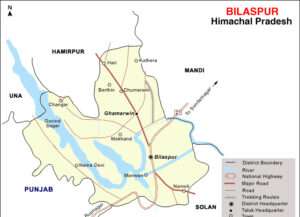
Geography of Bilaspur District
Bilaspur District Overview (official Data)
Geography
- Location: 31.33°N 76.75°E
- Elevation: Average of 673 meters (2,208 feet)
- Features: Situated at the foot of the Bandla Hills, along the left bank of the Sutlej River. The picturesque landscape is influenced by the Govind Sagar Dam.
- Significance: First major town in Himachal Pradesh on the way to Manali.
Geographical Position and Structure
- Area: 1167 square kilometers, which is 2.1% of Himachal Pradesh’s total area.
- Geographical Position:
- Latitude: 31°12’30” to 31°35’45”
- Longitude: 76°23’30” to 76°55’40”
- Position: Primarily in the outer hills, especially in the lower Satluj Valley.
- Geographical Structure: The entire district is located in the Shivalik Hills or the outer Himalayan ranges.
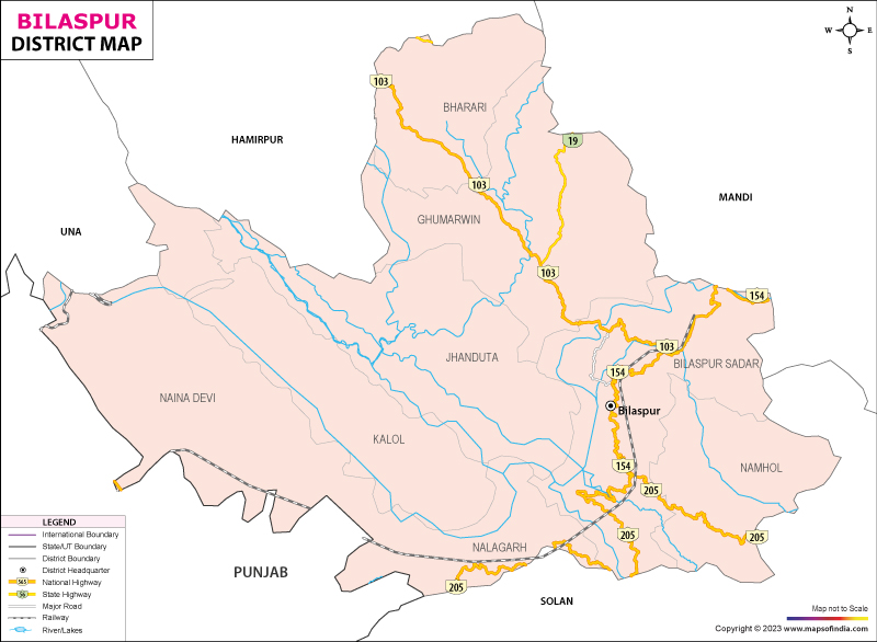
Boundaries
- North: Bounded by Mandi and Hamirpur districts.
- West: Bounded by Hamirpur and Una districts.
- South: Bounded by the Nalagarh region of Solan district.
Elevation
- Highest Point: Dhar Bahadurpur Peak at 1944 meters.
- Lowest Point: 305 meters.
River System
- Satluj River: The district is located on both banks of the Satluj River, which forms the boundary between Mandi and Bilaspur.
- Ali River: Originates from the Arki tehsil of Solan district and enters Bilaspur at Kothi Harar village. It joins the Satluj River at Ber-Ghat.
- Ghambar Khadd: Originates from the Tara Devi area in Shimla Hills and enters Bilaspur at Neri village. It merges with the Satluj River at Dagran village.
- Sear Khadd: Originates from Mandi district and enters Bilaspur at Hatwar village. It is the largest tributary of the Satluj River in the district.
Notable Hills of Bilaspur
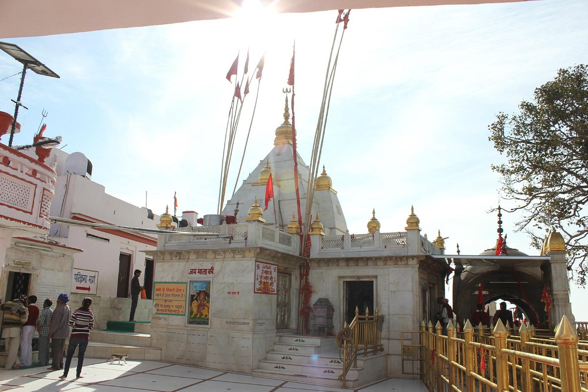
1. Naina Devi Hill:
- Highlights: Dominated by the revered Naina Devi Temple, this hill also features the historic Kot Kehloor Fort and Fatehpur Fort.
- Significance: A major pilgrimage destination offering spectacular views of the surrounding landscape and the Govind Sagar Lake.
2. Kot Hill:
- Highlights: This hill includes notable sites like Bachretu, Basiya, Naon, and Dagoga Malhot. The peak, “Kakerer,” stands as the highest point.
- Significance: Known for its elevated vantage points and historical significance.
3. Bandla Hill:
- Highlights: Famous for its paragliding opportunities and home to the Hydro Engineering College.
- Significance: A popular spot for adventure sports and academic institutions, offering stunning views and educational facilities.
4. Bahadurpur Hill:
- Highlights: This hill is split by Ali Khadd and houses the Bahadurpur Fort, which served as the summer residence of Raja Vijay Chand.
- Significance: Known for its historical fort and scenic beauty.
5. Ratanpur Hill:
- Highlights: The site where General Octerlony defeated Amar Singh Thapa, adding historical depth to its geographical prominence.
- Significance: Rich in historical battles and cultural heritage.
6. Zhanjiyar Hill:
- Highlights: Divided by Shir Khadd into the southern (Badol) and northern (Zhanjiyar) parts. It features significant temples like Devi Badoli and Gugga Gherwin.
- Significance: A key location for religious tourism with its ancient temples and serene environment.
7. Tiyun Hill:
- Highlights: Hosts several important sites including Saraiyun Fort, Nauranggarh, Harimba Devi Temple, and Siddh Gurunath.
- Significance: A hill rich in historical and religious sites, offering a blend of cultural and spiritual experiences.
These hills not only shape the picturesque landscape of Bilaspur but also hold significant historical and cultural value, making them essential landmarks in the region.
Notable Valleys
- Satluj Valley: The Satluj River enters the district at Kasol and exits at Naila.
- Chounto Valley: Located near the Bakhra Dam. Known for its flat and fertile land.
- Danwin Valley: Located between Bahadurpur and Bandla Hills, known for crops like maize, rice, sugarcane, ginger, and wheat.
Valleys of Bilaspur
Sutlej Valley:
- Location: Along the Sutlej River.
- Features: Known for its picturesque landscape, formed due to the creation of the Govind Sagar Dam. It includes rich agricultural land and scenic beauty.
- Significance: Important for hydroelectric projects and provides water resources for irrigation and drinking.
Chounto Valley:
- Location: Near the Bakhra Dam.
- Features: Characterized by flat and fertile land suitable for agriculture.
- Significance: Known for its agricultural productivity, particularly for crops like wheat and maize.
Danwin Valley:
- Location: Situated between the Bahadurpur and Bandla Hills.
- Features: Known for its agricultural fields, particularly for crops like maize, sugarcane, and ginger.
- Significance: Contributes to the local economy through its agricultural output.
Water Sources
- Luhund Falls: A major waterfall that supplies water to the district.
- Bassi Falls: Another important waterfall, significant for local climate and ecology.
- Govind Sagar Lake: A man-made lake, the largest in the district.
Languages Spoken
- Kahluri: The main local dialect, considered a branch of Punjabi.
- Hindi: A major language used in government work and education.
- English: Also important, particularly in educational and administrative contexts.
This overview provides a comprehensive look at Bilaspur District’s geographical position, river system, notable hills and valleys, water sources, and languages.
Govind Sagar Lake
- Elevation: Approximately 450 meters (1,476 feet) above sea level.
- Built By: The lake was created by the construction of the Bhakra Dam on the Satluj River.
- Purpose: The Bhakra Dam, which created the Govind Sagar Lake, was built for flood control, irrigation, and hydroelectric power generation. It also provides drinking water and supports recreational activities.
- Specifications:
- Type: Artificial reservoir
- Area: Around 168.35 square kilometers (65 square miles) when full.
- Volume: Can store about 9.34 billion cubic meters of water.
Additional Information
- Wiki Link for Govind Sagar Lake: Govind Sagar Lake – Wikipedia
For detailed and updated information, visiting the Wikipedia page or official resources related to the Bhakra Dam and Govind Sagar Lake would be useful.
Rukmani Kund Overview
- Location: Bilaspur District, Himachal Pradesh.
- Legend: Named after Rukmani, who was buried alive by her husband’s family. She offered herself in place of her husband when the family was digging a tank.
- Water Characteristics: Bluish water, never dries up, even during summer. Known for breeding a special type of fish.
- Features:
- Temple: Small temple dedicated to Rukmani Devi.
- Cave: Leads to Gugaji Temple on the other side of a hill.
- Cultural Significance:
- Local Practice: People from Rukmani’s village avoid bathing or drinking from the kund’s water in honor of her sacrifice.
- Annual Fair: Held during Baisakhi festival, attracting many visitors.
- Importance: The site is both a religious and cultural landmark, reflecting local traditions and legends.
Koldam Hydropower Station – Key Points
1. Location:
- Site: Sutlej River, 18 km from Bilaspur, near Barmana, Himachal Pradesh
- Highway: Off Chandigarh-Manali Highway (NH-21)
2. Purpose:
- Function: Hydroelectric power generation
- Capacity: 800 MW
3. Construction:
- Foundation Stone Laid: 5 June 2000
- Main Construction Started: 14 January 2004
- Commissioning: Originally planned for 2009, rescheduled to 2015
Note: Managed By NTPC
Climate
- Summers: Warm, with temperatures reaching up to 38°C (100°F), sometimes exceeding 40°C (104°F).
- Winters: Cool, protected from extreme temperatures by the valley.
- Monsoon: High rainfall from July to September. Govind Sagar Lake is full from October to November.
Demographics
- Population (2001 Census): 13,058
- Gender Ratio: 56.25% males, 43.75% females
- Literacy Rate: 91%, higher than the national average of 74%
- Age Distribution: 10% under 6 years of age
- Occupation: Predominantly in the services sector; residents live in the city or commute from nearby areas.
Landmarks
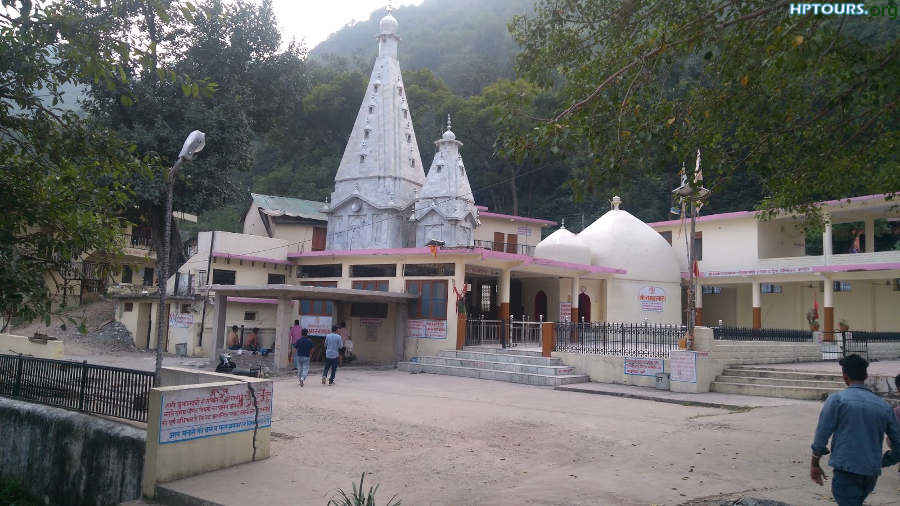
Naina Devi Temple
- Location: Naina Devi hilltop
- Features: Accessible by road, concrete steps, and cable car. Overlooks Govind Sagar Lake.
Bhakra Dam
- Location: Across the Sutlej River
- Features: Concrete gravity dam, 226 meters high, 518.25 meters long. Reservoir (Gobind Sagar) stores 9.34 billion cubic meters of water.
Gobind Sagar
- Type: Reservoir formed by the Bhakra Dam
- Significance: Third-largest reservoir in India by water capacity.
Baba Nahar Singh Temple
- Location: Dholra
- Features: Dedicated to Baba Nahar Singh, associated with local legends. Fairs held every Tuesday in mid-May to mid-June.

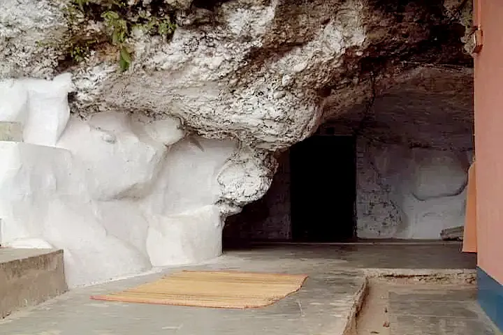
Vyas Gufa
- Location: Left bank of the Sutlej River
- Significance: Believed to be the penance site of Rishi Vyas of Mahabharata fame.
Laxmi Narayan Temple
- Deity: Laxmi Narayan
Sidh Baba Balak Nath Cave Temple
- Location: Deotsidh
- Features: Dedicated to Baba Balak Nath, a revered deity. Women are not allowed in the main garbagriha.
Markandeya Temple
- Location: Ghagus-Brahmpukhar road
- Significance: Associated with Rishi Markandeya’s legend and worship.
Hadimba Devi Temple
- Location: Chalehli Village
- Deity: Goddess Durga (Hadimba Devi)
Badol Devi Temple
- Location: Badol Village
- Deity: Goddess Durga (Badol Devi)

Kandrour Bridge
- Location: 8 km from Bilaspur
- Features: Bridge across the Sutlej River, completed in 1965.
Rukmani Kund
- Location: Bhager-Gehrwin route
- Features: Rock water body with religious significance.
Gugga Gehrwin Temple
- Location: Cliff near Gehrwin
- Deity: Gugga
Purnam Mall
- Completed: 2017
- Features: Includes a cineplex, shopping stores, restaurants, and bars.
Notable People from Bilaspur
Bhandari Ram
- Achievement: Recipient of the Victoria Cross
- Significance: Awarded for valor during combat, a prestigious military honor.
Sanjay Kumar
- Achievement: Param Vir Chakra recipient
- Significance: India’s highest military decoration for valor in the face of the enemy.
Suresh Chandel
- Occupation: Indian Politician
- Significance: Known for his contributions in Indian politics, representing Bilaspur in various capacities.
Jagat Prakash Nadda
- Position: President of the Bharatiya Janata Party (BJP) and Former Union Minister of Health and Family Welfare
- Significance: Prominent political leader with significant influence in Indian politics. His residence is in Vijaypur.
Rattan Chand
- Occupation: Senior Bureaucrat, Government of India; Advisor, World Bank
- Significance: Known for his administrative expertise and contributions to global development.
Yami Gautam
- Profession: Bollywood/Television Actress
- Significance: Renowned actress known for her roles in Indian cinema and television.
Zorawar Singh Kahluria
- Rank: Army General
- Significance: Distinguished military leader with significant contributions to the Indian Army.
- Where is Bilaspur located?
- 33°N 76.75°E
- 25°N 77.85°E
- 12°N 75.25°E
- 50°N 78.50°E
- What is the average elevation of Bilaspur?
- 673 meters
- 600 meters
- 750 meters
- 500 meters
- Which river is Bilaspur situated along?
- Yamuna
- Ganges
- Sutlej
- Beas
- Which dam is associated with the creation of Govind Sagar Lake?
- Tehri Dam
- Narmada Dam
- Bhakra Dam
- Nagarjunasagar Dam
- What is the highest temperature usually recorded in Bilaspur during May and June?
- 30°C
- 35°C
- 37°C
- 40°C
- According to the 2001 census, what is the literacy rate in Bilaspur?
- 85%
- 90%
- 91%
- 95%
- Who is a Victoria Cross recipient from Bilaspur?
- Sanjay Kumar
- Suresh Chandel
- Bhandari Ram
- Jagat Prakash Nadda
- Which temple is located on a hilltop in Bilaspur and overlooks the Govind Sagar Lake?
- Laxmi Narayan Temple
- Sidh Baba Balak Nath Temple
- Naina Devi Temple
- Markandeya Temple
- What is the length of the Bhakra Dam?
- 300 meters
- 25 meters
- 400 meters
- 550 meters
- Which landmark is described as a “New Temple of Resurgent India” by Jawaharlal Nehru?
- Gobind Sagar
- Bhakra Dam
- Vyas Gufa
- Kandrour Bridge
- What is the name of the reservoir created by the Bhakra Dam?
- Narmada Sagar
- Indira Sagar
- Gobind Sagar
- Nagarjunasagar
- Which temple is associated with the local deity Gugga?
- Badol Devi Temple
- Gugga Gehrwin Temple
- Rukmani Kund Temple
- Hadimba Devi Temple
- Who is the current President of the Bharatiya Janata Party (BJP) from Bilaspur?
- Suresh Chandel
- Jagat Prakash Nadda
- Rattan Chand
- Yami Gautam
- In which month does the annual fair at Baba Nahar Singh Temple take place?
- January
- April
- May
- July
- Which temple is located on the Ghagus-Brahmpukhar road?
- Markandeya Temple
- Sidh Baba Balak Nath Temple
- Naina Devi Temple
- Laxmi Narayan Temple
- What is the height of the Kandrour Bridge above the river bed?
- 50 meters
- 60 meters
- 80 meters
- 100 meters
- What is the notable feature of Rukmani Kund?
- It is a man-made reservoir
- It has bluish water that never dries up
- It is located near the Bhakra Dam
- It is associated with Vyas Rishi
- Which temple is dedicated to Baba Balak Nath?
- Markandeya Temple
- Sidh Baba Balak Nath Temple
- Badol Devi Temple
- Baba Nahar Singh Temple
- What is the significant feature of Vyas Gufa?
- It is a natural cave believed to be inhabited by Rishi Vyas
- It is a man-made temple
- It is located on the right bank of the Sutlej River
- It is a major water reservoir
- Which Bollywood actress hails from Bilaspur?
- Priyanka Chopra
- Deepika Padukone
- Yami Gautam
- Kareena Kapoor
Here is the answer key for the provided MCQs:
- A) 31.33°N 76.75°E
- A) 673 meters
- C) Sutlej
- C) Bhakra Dam
- C) 37°C
- C) 91%
- C) Bhandari Ram
- C) Naina Devi Temple
- B) 518.25 meters
- B) Bhakra Dam
- C) Gobind Sagar
- B) Gugga Gehrwin Temple
- B) Jagat Prakash Nadda
- C) May
- A) Markandeya Temple
- C) 80 meters
- B) It has bluish water that never dries up
- B) Sidh Baba Balak Nath Temple
- A) It is a natural cave believed to be inhabited by Rishi Vyas
- C) Yami Gautam
भौगोलिक स्थिति और संरचना
- क्षेत्रफल: 1167 वर्ग किलोमीटर, जो हिमाचल प्रदेश के कुल क्षेत्रफल का 2.1% है।
- भौगोलिक स्थिति:
- उत्तरी अक्षांश: 31°12’30” से 31°35’45”
- पूर्वी देशांतर: 76°23’30” से 76°55’40”
- स्थिति: मुख्यतः बाहरी पहाड़ियों में, विशेष रूप से निचली सतलुज घाटी में।
- भौगोलिक संरचना: पूरा जिला शिवालिक या हिमालय की बाहरी पहाड़ियों में स्थित है।
सीमाएं
- उत्तर: मंडी और हमीरपुर जिलों से।
- पश्चिम: हमीरपुर और ऊना जिलों से।
- दक्षिण: सोलन जिले के नालागढ़ क्षेत्र से।
ऊंचाई
- उच्चतम बिंदु: धार बहादुरपुर चोटी पर 1944 मीटर।
- न्यूनतम बिंदु: 305 मीटर।
नदी प्रणाली
- सतलुज नदी: जिला सतलुज नदी के दोनों किनारों पर स्थित है, जो मंडी और बिलासपुर के बीच की सीमा बनाती है।
- अली नदी: सोलन जिले की अर्की तहसील से निकलती है और कोठी हरार गांव में बिलासपुर में प्रवेश करती है।
- घंबर खड्ड: शिमला पहाड़ियों में तारा देवी के बीच से निकलती है और नेरी गांव में बिलासपुर में प्रवेश करती है।
- सीर खड्ड: मंडी जिले से निकलती है और हटवार गांव में बिलासपुर में प्रवेश करती है।
प्रसिद्ध पहाड़ियाँ
- नैना देवी: नैना देवी, कोट कहलूर किला और फतेहपुर किला यहाँ स्थित हैं।
- कोट पहाड़ी: बछरेटू, बसियाह, नौन और दागोगा मलहोत इस पहाड़ी पर स्थित हैं।
- बहादुरपुर पहाड़ी: अली खड्ड द्वारा दो भागों में विभाजित। बहादुरपुर किला राजा बिजय चंद का ग्रीष्मकालीन निवास था।
- रतनपुर पहाड़ी: यहाँ जनरल ऑक्टरलोनी ने अमर सिंह थापा को हराया था।
- झंजियार पहाड़ी: शीर खड्ड द्वारा दो भागों में विभाजित। देवी बडोली और गुग्गा घेरवीं मंदिर यहाँ स्थित हैं।
- तियुन पहाड़ी: किला सरियुन, नौरंगगढ़, हरिम्बा देवी मंदिर और सिद्ध गुरुनाथ इस पहाड़ी पर स्थित हैं।
प्रसिद्ध घाटियाँ
- सतलुज घाटी: सतलुज नदी कसोल में प्रवेश करती है और बिलासपुर जिले के नैला में निकलती है।
- चौंटो घाटी: बखरा बांध के पास स्थित। यह समतल और उपजाऊ भूमि है।
- डैनविन घाटी: बहादुरपुर और बंदला पहाड़ियों के बीच स्थित। मक्का, चावल, गन्ना, अदरक और गेहूं की फसलों के लिए प्रसिद्ध है।
जल स्रोत
- लुहुंड झरना: एक प्रमुख झरना जो जिले में पानी की आपूर्ति करता है।
- बस्सी झरना: दूसरा महत्वपूर्ण झरना जो स्थानीय जलवायु और पारिस्थितिकी के लिए महत्वपूर्ण है।
- गोविंद सागर झील: मानव निर्मित झील, जो जिले की सबसे बड़ी झील है।
भाषाएँ
- कहलूरी: मुख्य स्थानीय बोली, पंजाबी की एक शाखा।
- हिन्दी: सरकारी कामकाज और शिक्षा में प्रयुक्त।
- अंग्रेजी: शैक्षिक और प्रशासनिक कार्यों में महत्वपूर्ण।
यह विवरण बिलासपुर जिले की भौगोलिक स्थिति, नदी प्रणाली, प्रमुख पहाड़ियाँ और घाटियाँ, जल स्रोत और भाषाओं का एक व्यापक अवलोकन प्रदान करता है।