Geographical Location and Extent of Himachal Pradesh
State Profile of Himachal Pradesh
| Attribute | Details |
|---|---|
| Area | 55,673 km² |
| Total Population | 7,781,244 |
| Males | 3,946,646 |
| Females | 3,834,598 |
| Population Density | 123 per km² |
| Sex Ratio | 972 females per 1,000 males |
| Rural Population | 6,176,050 |
| Urban Population | 688,552 |
| Scheduled Caste Population | 1,729,252 |
| Scheduled Tribe Population | 392,126 |
| Literacy Rate | 83.78% |
| Male Literacy Rate | 90.83% |
| Female Literacy Rate | 76.60% |
| Capitals | 2 (Shimla and Dharamshala) |
| Districts | 12 |
| Sub-divisions | 71 |
| Tehsils | 169 |
| Sub-tehsils | 38 |
| Developmental Blocks | 78 |
| Towns | 59 |
| Panchayats | 3,243 |
| Panchayat Samities | 77 |
| Zila Parishad | 12 |
| Urban Local Bodies | 59 |
| Nagar Nigams | 2 |
| Nagar Parishads | 25 |
| Nagar Panchayats | 23 |
| Census Villages | 20,690 |
| Inhabited Villages | 17,882 |
| Health Institutions | 3,866 |
| Educational Institutions | 17,000 |
| Motorable Roads | 33,722 km |
| National Highways | 8 |
| Identified Hydroelectric Potential | 23,000.43 MW |
| Potential Harnessed | 10,264 MW |
| Food Grain Production | 1.528 million MT |
| Vegetable Production | 1.867 million MT |
| Fruit Production | 1,027,000 tonnes |
| Per Capita Income | ₹2,01,854 (2021–22) |
| Social Security Pensions | 237,250 persons; Annual expenditure: over ₹ 600 million |
| Investment in Industrial Areas | ₹273.80 billion; Employment opportunities: Over 337,391 |
| Employment Generated in Government Sector | 217,142 |
Introduction
This profile highlights the key demographic, economic, and infrastructural aspects of Himachal Pradesh, reflecting its diverse and growing landscape.
Himachal Pradesh, located in the western Himalayas, is known for its diverse topography and rich natural resources. Covering an area of 55,673 km² (21,495 sq mi), it is bordered by Jammu and Kashmir and Ladakh to the north, Punjab to the southwest, Haryana to the south, Uttarakhand to the southeast, and Tibet to the east. This mountainous state is a part of the Himalaya region, characterized by its varied elevations and extensive river systems.
Topography and Elevation
Mountain Ranges and Peaks
Himachal Pradesh’s topography is dominated by the Himalayan mountain ranges, including the Shivalik, Lesser Himalayas, Great Himalayas, and Zanskar ranges. The highest point in the state is Reo Purgyil, which stands at 6,816 meters (22,362 feet).
- Shivalik Range: The southernmost range with lower hills around 600 meters above sea level.
- Lesser Himalayas: Includes prominent ranges like Dhauladhar and Pir Panjal. The Kangra valley lies at the foot of the Dhauladhar range.
- Great Himalayas: Runs along the eastern boundary with peaks ranging from 5,000 to 6,000 meters.
- Zanskar Range: The easternmost range, separating Himachal Pradesh from Tibet and Ladakh, featuring peaks like Mount Gya and Reo Purgyil.
Himachal Pradesh, located in the western Himalayas, spans between 30°22′N and 33°12′N latitude and 75°47′E and 79°04′E longitude. The state covers an area of 55,673 square kilometers (21,495 square miles) and is characterized by its mountainous terrain. Here’s an overview of its geographical features:
Mountain Ranges
- Zanskar Range: Situated in the northeastern part of the state.

- Great Himalayan Range: Extends through the eastern and northern parts of Himachal Pradesh.

- Dhauladhar Range: Part of the lesser Himalayas, forming much of the central regions of the state.

- Pir Panjal Range: Also part of the lesser Himalayas, running through the state’s central region.

- Shiwalik Range: The outer Himalayas, which form the southern and western boundaries of Himachal Pradesh.

Highest Peak
- Reo Purgyil: This peak is indeed the highest in Himachal Pradesh, with an elevation of 6,816 meters (22,362 feet).

- Shilla Peak: With a height of 7,025 -26 meters (23,089 feet), Shilla Peak is a significant peak located in the Zanskar range, near the Spiti Valley. It surpasses Reo Purgyil in elevation.
Drainage System
Himachal Pradesh features a complex drainage system fed by both rivers and glaciers:
- Rivers: The state provides water to the Indus and Ganges basins through several major rivers:
- Chenab (Chandra-Bhaga): Originates in the state and flows through Lahaul and Pangi.
- Ravi: Flows predominantly through Chamba.
- Beas: Passes through Kullu and Kangra Valleys; its tributary, the Parvati River, forms the Parvati Valley.
- Sutlej: Enters the state near Shipki La, forming the Satluj Valley.
- Yamuna: Includes the Pabbar and Giri rivers in the southeast.
Valleys
- Satluj Valley: Formed by the Sutlej River.

- Spiti and Baspa Valleys: Created by tributaries of the Sutlej River.

- Kullu Valley: Carved by the Beas River.

- Kangra Valley: Also shaped by the Beas River.

- Parvati Valley : Parvati Valley is a Himalayan valley situated in the northern Indian state of Himachal Pradesh. From the confluence of the Parvati River with the River Beas, the valley runs eastwards, through a steep-sided valley from the town of Bhuntar, in the Kullu district of Himachal Pradesh in Northern India.

Climate
The climate of Himachal Pradesh varies significantly due to its diverse elevation:
- Southern Regions: Experience a hot and humid subtropical climate.
- Central and Higher Elevations: Conditions range from cold and alpine to glacial.
- Dharamsala: Known for its very heavy rainfall.
- Lahaul and Spiti: Characterized by cold and almost rainless conditions.
Seasons
- Summer: From mid-April to the end of June, with temperatures ranging from 28 to 32 °C (82 to 90 °F), except in the alpine zone, which has a milder climate.
- Winter: Lasts from late November to mid-March, with snowfall common in alpine areas.
- Rainy Season: Characterized by heavy rains, particularly in the southern parts of the state.
- Geography of Lahaul
- Geography of Mandi
- River System in Himachal
- Lakes of Himachal Pradesh
- Geography Of Chamba District
- Kullu District Complete Geography
- Kinnaur District
- Geography of Kangra
- Geography Of Solan
- Geography of Bilaspur
- Geography of Hamirpur
- Geography of Sirmaur
- Geography of Una
- Geography of Shimla
Environmental Initiatives
Himachal Pradesh has made significant strides in environmental conservation, including becoming the first smoke-free state in India. This initiative means that traditional cooking methods, which involve burning wood or coal, have been largely replaced with cleaner alternatives.
Physiographic Divisions
The state’s physiography can be divided into four general zones from south to north:
- Outer Himalayas (Shivaliks)
- Lesser Himalayas (Central Zone)
- Great Himalayas (Northern Zone)
- Zanskar Range
Also Read This : Physiographic Zones
Shivaliks (Outermost Range):
- Altitude: 350 to 1500 meters.
- Rainfall: 150 cm to 180 cm.
- Description: Also known as “Manak Parbat,” meaning “tresses of Shiva.” This range covers parts of Kangra, Hamirpur, Bilaspur, Una, Mandi, Solan, and Sirmaur. It includes regions such as Paonta Valley, Nahan, Pachhad, Renuka, Balh Valley, and Jogindernagar. The Shivaliks are characterized by relatively lower altitudes compared to other ranges.
Inner Himalayas:
- Altitude: 1500 to 4500 meters.
- Description: This zone features significant ranges like Dhauladhar and Pir Panjal. Important locations in this zone include Renuka Tehsil, Chachiot, Karsog, Dalhousie, Shimla, Choorchandani (with Choorchandani Peak at 3647 meters), and Kullu Valley. Dhauladhar, also known as “Maulak Parbat,” runs through Chamba, Kangra, and Mandi and intersects with major rivers like Satluj, Beas, and Ravi. The Pir Panjal range separates Chenab from Ravi and Beas rivers.
Greater Himalayas:
- Altitude: Above 4500 meters.
- Description: This range forms a natural divide between the Spiti and Beas rivers and includes the Zanskar range, which separates Spiti and Kinnaur from Tibet. Key peaks include Shilla (7025 meters), Riwo (Liwo) Pargyul (6791 meters). It encompasses Kinnaur, Pangi, and Lahaul-Spiti. The region is known for its very low rainfall, making it suitable for dry fruits. Notable passes in this range include Sach, Chini, Chabla, Kugti, Hamta, and Chandarkherni.
Climatic Zones
Wet Sub-temperate Zone:
- Description: Characterized by high rainfall and moderate temperatures. This zone includes areas such as Palampur, Joginder Nagar, Dalhousie, and Dharamshala.
Humid Sub-temperate Zone:
- Description: Experiences moderate rainfall and cooler temperatures. Key locations are Kullu, Shimla, and parts of Mandi, Solan, Chamba, Kangra, and Sirmaur.
Dry Temperate Zone:
- Description: Noted for low rainfall and colder temperatures. This zone covers the alpine high areas of Lahaul-Spiti, Pangi, and Kinnaur.
Humid Sub-tropical Zone:
- Description: Features higher rainfall and warmer temperatures. Areas include Mandi, Nahan, Nalagarh, and Nurpur.
Sub-humid Tropical Zone:
- Description: Has moderate rainfall with warmer temperatures. Key locations are Una, Paonta Sahib, and the Indora area of Kangra.
Rainfall Extremes
- Average Rainfall: 152 cm.
- Wettest Place: Dharamshala, receiving about 340 cm of rainfall.
- Driest Place: Spiti, known for its very low rainfall.
Special Climatic Phenomena
- Gravity Winds: Vertical air movements caused by temperature changes, where winds move from ridges to valley bottoms after sunset.
- Western Disturbances: Mid-latitude westerly winds that bring weather changes to the western Himalayas.
- Jet Stream: High-speed winds in the upper atmosphere, prevalent at high elevations during winter.
- Lee Waves: Strong winds on the leeward side of mountains, causing erosion and damage.
- Southwest Monsoon: Brings the maximum rainfall to the Himalayas.
- Winter Monsoon: Similar to northeast trade winds, influencing the region during winter.
These zones and phenomena highlight the diverse and complex climatic and physiographic conditions of Himachal Pradesh, affecting its environment, agriculture, and daily life.
Major Rivers and Basins
Indus and Ganges River Basins
Himachal Pradesh encompasses parts of both the Indus and Ganges river basins. Major rivers originating in the state include:
- Chenab River: Originates in the state and flows northwestwards.
- Ravi River: Begins at Bara Bhangal and flows westwards.
- Beas River: Flows south from Beas Kund through the Kullu and Kangra valleys.
- Satluj River: Enters from Tibet and flows through Kinnaur, with tributaries like Spiti and Baspa.
- Pabbar and Giri Rivers: Tributaries of the Yamuna, flowing through Shimla and Sirmour.
Other Notable Rivers
- Chandra and Bhaga Rivers: Rise in the Lahaul region and merge to form the Chenab River.
- Ghaggar River: A monsoonal river originating in the state.
Flora and Fauna
Forests and Vegetation
Himachal Pradesh is known for its rich biodiversity and forest cover, which was about 27.72% of the state’s area as of 2019. The state’s forests range from:
- Northwestern Thorn Scrub Forests: Found in the lower elevations.
- Himalayan Subtropical Pine Forests: Dominating the lower Himalayan foothills.
- Western Himalayan Broadleaf Forests: Found at elevations of 1,500 to 2,600 meters.
- Western Himalayan Alpine Shrub and Meadows: Above 3,000 meters.
National Parks
The state hosts five national parks, including:
- Great Himalayan National Park (World Heritage Site)
- Pin Valley National Park
- Inderkilla National Park
- Khirganga National Park
- Simbalbara National Park
The geology of Himachal Pradesh:
is a complex and fascinating subject due to its dynamic geological history and the significant tectonic processes that have shaped its landscape. Located in the Western Himalaya, Himachal Pradesh is characterized by a diverse range of rock types and structures that have been influenced by the collision between the Indian and Asian tectonic plates.
Major Tectonic Units

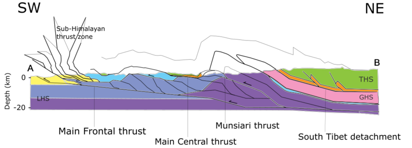
- Indo-Gangetic Plain:
- Location: Southwestern fringe of Himachal Pradesh.
- Composition: Alluvial sediments from the Himalayas.
- Features: High sediment flux from major rivers; erosion rates contribute to significant sedimentation.
- Sub-Himalayan Sequence (Siwalik Group):
- Age: Paleocene to Pliocene.
- Composition: Sedimentary layers including sandstone, conglomerate, and shale.
- Features: Deposits from shallow marine to continental environments; heavily thrust and accreted.
| Age Range | Unit | Lithology | Deposition Environment |
|---|---|---|---|
| Pleistocene-Miocene | Siwalik Formation | Sandstone, conglomerate, siltstone | Continental |
| Miocene | Dharamsala Formation | Gray sandstone, siltstone, shale, caliche | Continental |
| Latest Paleocene-Middle Eocene | Subathu Formation | Limestone, shale, minor fine-grained sandstone | Shallow marine |
| Late Cretaceous-Paleocene | Singtali Formation | Limestone, minor quartz arenite | Shallow marine |
This table provides a clear and concise overview of the different units within the Sub-Himalayan Sequence, including their age ranges, lithologies, and depositional environments.
This table provides a clear and concise overview of the different units within the Sub-Himalayan Sequence, including their age ranges, lithologies, and depositional environments.
- Lesser Himalayan Sequence:
- Age: Paleoproterozoic to Cambrian.
- Composition: Metasedimentary rocks, metavolcanic rocks, and augen gneiss.
- Features: Divided into four units; metamorphosed into greenschist and amphibolite facies rocks.
- Greater Himalayan Crystalline Complex:
- Age: Paleoproterozoic to Ordovician.
- Composition: High-grade metamorphic rocks such as paragneiss, schist, and orthogneiss.
- Features: Experienced peak metamorphic conditions; contains leucogranites.
- Tethyan Himalayan Sequence:
- Age: Neoproterozoic to Cretaceous.
- Composition: Fossiliferous sedimentary strata and igneous rocks.
- Features: Includes early Paleozoic granitoids and Neoproterozoic granite.
Geological Processes and Models
- Collision and Orogeny: The region’s geology has been significantly shaped by the India-Asia collision, leading to the formation of the Himalayas. This collision has resulted in extensive thrusting, folding, and deformation of rock sequences.
- Thrust Wedge Development: The interaction between the Indian and Asian plates has led to the development of a thrust wedge. This involves processes such as frontal accretion, underplating, and out-of-sequence faulting.
- Exhumation Models:
- Wedge Extrusion Model: Suggests the Greater Himalayan Crystalline Complex was exhumed and moved southwestward, leading to the formation of normal faults.
- Channel Flow Model: Proposes that the Greater Himalayan Crystalline Complex originated from Tibetan crust and migrated southward as a crustal flow.
- Tectonic Wedging Model: Suggests that the Greater Himalayan Crystalline Complex was emplaced at depth and thrust southwestward between the Tethyan Himalayan Sequence and Lesser Himalayan Sequence.
Climatic and Erosional Influences
- Precipitation: Orographic precipitation is concentrated in specific areas, leading to high erosion rates, particularly in regions with high rainfall.
- Glaciation: Glacial processes have played a significant role in shaping the landscape through erosion and deposition, affecting river discharge and erosive power.
Exhumation of Crustal Materials
Exhumation refers to the upward movement of rocks towards the Earth’s surface. This process can be driven by surface erosion, tectonic uplift, or a combination of both. In Himachal Pradesh, this exhumation is heavily influenced by climatic factors such as precipitation and glaciation.

Fig. Major rivers in Himachal Pradesh. The black ellipse indicates the area that receives high rainfall.[8]Figure made with GeoMapApp (www.geomapapp.org) / CC BY / CC BY (Ryan et al., 2009).
Precipitation Patterns
- Distribution: Rainfall in Himachal Pradesh is unevenly distributed, with significant orographic precipitation occurring in a 50–70 km wide zone at elevations between 2000-3500 meters. This area aligns with the Kulu window.
- Intensity: The region receives more than 2000 mm of rainfall per year, which is twice the global average of 1000 mm per year.
Effects of Precipitation
- Orographic Precipitation: High rainfall in the Kulu window leads to effective rock removal through fluvial erosion. Major rivers, such as the Sutlej River, which traverse tectonic windows, experience increased erosion.
- Denudation: The concentrated rainfall causes rapid denudation (removal of surface material), which enhances local isostatic and tectonic uplift. This process brings hotter rocks from depth to the surface, promoting heat advection within the crust.
- Surface Processes: The elevated precipitation facilitates the weakening and erosion of rocks, maintaining steep topography and contributing to the overall exhumation of crustal materials.
Impact on Tectonics
- Positive Feedback Loop: The removal of surface material through erosion and landslides creates a positive feedback loop. This feedback accelerates the exhumation process and contributes to the steep terrain observed in Himachal Pradesh.
Summary
In Himachal Pradesh, the climatic factors of precipitation and glaciation significantly control topographic growth. The high rainfall in specific areas leads to rapid erosion, which in turn promotes tectonic uplift and contributes to the exposure of deep-seated rocks at the surface. This interaction between climatic conditions and tectonic processes shapes the region’s rugged topography.
Geohazards in Himachal Pradesh
Earthquake Zones:

- Zone IV (Severe Intensity Zone): Represents earthquake intensity VIII on the Modified Mercalli scale.
- Zone V (Severe Intensity Zone): Represents earthquake intensity IX on the Modified Mercalli scale.
Seismic Faults:
- Main Frontal Thrust (MFT)
- Main Central Thrust (MCT)
- Main Boundary Thrust (MBT)
Seismic Activity:
- Himachal Pradesh is highly seismic due to its location within these severe intensity zones and proximity to major seismic faults.
- The region experiences significant earthquake activity because of the ongoing tectonic interactions between the Indian Plate and the Eurasian Plate.
Implications:
- High seismic activity poses risks such as ground shaking, landslides, and infrastructure damage.
This information emphasizes the earthquake risk in Himachal Pradesh and highlights the key seismic faults contributing to this hazard.
Agriculture in Himachal Pradesh
Overview
Agriculture is a crucial sector in Himachal Pradesh, contributing significantly to the state’s economy and employment. It accounts for 9.4% of the net state domestic product and provides direct employment to 62% of the state’s workforce. Approximately 90% of the population is engaged in agriculture, making it a key source of income and livelihood.
Farming Practices
- Terrace Farming: The most common agricultural practice in Himachal Pradesh is terrace farming, which is well-suited to the state’s mountainous terrain.

- Traditional Irrigation: The Kuhl irrigation system, a centuries-old method, is prevalent in the Kangra valley. However, this traditional system faces challenges from modern hydroprojects affecting small streams.
Major Crops
- Cereals: The main cereals grown include wheat, maize, rice, and barley. Key cropping systems involve combinations such as maize-wheat, rice-wheat, and maize-potato-wheat.
- Other Crops: Pulses, fruits, vegetables, and oilseeds are also cultivated.
Apple Cultivation

- Importance: Apples are the principal cash crop in Himachal Pradesh. The state is the second-largest apple producer in India, contributing 49% of the total area under fruit crops and 85% of the total fruit production.
- Production: The state produces an average of 500,000 tonnes of apples annually, with a per-hectare yield of 8 to 10 tonnes. The total area under apple cultivation increased from 90,347 hectares in 2000–01 to 104,000 hectares in 2011–12.
- Economic Impact: Apple cultivation has an estimated economy of ₹3500 crore and supports exports to other Indian states and international markets. In fiscal 2015–16, the annual apple production stood at 753,000 tonnes.
Other Fruits
In addition to apples, Himachal Pradesh is a leading producer of apricots, cherries, peaches, pears, plums, and strawberries in India.
Tea Production
- Kangra Tea: Grown in the Kangra valley, tea production began in 1849. At its peak in the late 19th century, Kangra tea gained global popularity.

- Decline: Production declined sharply after the 1905 Kangra earthquake but the tea received geographical indication status in 2005. Despite the historical decline, Kangra tea remains a notable product.
Land Husbandry Initiatives
- Mid-Himalayan Watershed Development Project: Includes the Himachal Pradesh Reforestation Project (HPRP), the world’s largest clean development mechanism (CDM) undertaking, which has improved agricultural yields and productivity and increased rural household incomes.
In summary, agriculture in Himachal Pradesh is characterized by traditional practices like terrace farming and a strong focus on cash crops like apples. The state’s diverse agricultural output and strategic land husbandry efforts underscore its vital role in the regional economy.
Etymology of Himachal Pradesh
The name “Himachal Pradesh” is derived from Sanskrit, reflecting its geographical and cultural significance.
- Himachal: The term “Himachal” combines two Sanskrit words:
- Hima (हिम): Meaning “snow”
- Acala/Achala (अचल): Meaning “slopes,” “land,” or “abode”
Together, “Himachal” translates to “snow-laden slopes” or “land in the lap of snowy Himalayas.”
- Pradesh: This Sanskrit word means “state.”
So, “Himachal Pradesh” literally means “snow-laden province” or “state in the lap of the snowy Himalayas.”
Historical and Cultural References
- Historical Reference: The name “Himachal” was popularized by Diwakar Datt Sharma, a Sanskrit scholar, following India’s independence. The name gained prominence when it was mentioned in the context of the national anthem, “Jana Gana Mana,” by Gurudev Rabindranath Tagore. It symbolically references the region’s location and cultural heritage.
- Political Context: After the partition of Punjab in 1947, the newly formed mountain state was officially named Himachal Pradesh, aligning with its geographical and cultural identity.
In essence, the name Himachal Pradesh embodies the state’s natural beauty, nestled in the Himalayas, and reflects its rich cultural and historical roots.
Q.1 What is the highest mountain peak in Himachal Pradesh?
A. Shilla Peak
B. Reo Purgyil
C. Dhauladhar
D. Pir Panjal
Answer: A
Explanation: Shilla Peak is the highest mountain peak in Himachal Pradesh, standing at 7,025 meters (23,078 feet).
Q.2 Which river forms the Parvati Valley?
A. Chenab
B. Ravi
C. Beas
D. Satluj
Answer: C
Explanation: The Parvati Valley runs eastwards from the confluence of the Parvati River with the River Beas.
Q.3 Which mountain range in Himachal Pradesh is also known as “Manak Parbat”?
A. Shivaliks
B. Dhauladhar
C. Pir Panjal
D. Greater Himalayas
Answer: A
Explanation: The Shivaliks, the outermost range in Himachal Pradesh, is also known as “Manak Parbat.”
Q.4 What is the average annual apple production in Himachal Pradesh?
A. 500,000 tonnes
B. 753,000 tonnes
C. 1,000,000 tonnes
D. 2,000,000 tonnes
Answer: B
Explanation: The annual apple production in Himachal Pradesh for fiscal 2015-16 was 753,000 tonnes.
Q.5 Which valley in Himachal Pradesh is known for its tea gardens?
A. Kullu Valley
B. Spiti Valley
C. Kangra Valley
D. Parvati Valley
Answer: C
Explanation: Kangra Valley is known for its tea gardens, and Kangra tea received geographical indication status in 2005.
Q.6 Which of the following is a part of the Shivalik range?
A. Kangra Valley
B. Kullu Valley
C. Beas Valley
D. Chamba Valley
Answer: A
Explanation: Parts of the Shivalik range include areas like Kangra, Hamirpur, Bilaspur, Una, Mandi, Solan, and Sirmaur.
Q.7 What is the primary climatic feature of the Dry Temperate Zone in Himachal Pradesh?
A. Heavy rainfall
B. High humidity
C. Low rainfall
D. Mild summer
Answer: C
Explanation: The Dry Temperate Zone in Himachal Pradesh, which includes parts of Lahual Spiti, Pangi, and Kinnaur, experiences low rainfall.
Q.8 Which river forms the Satluj Valley in Himachal Pradesh?
A. Yamuna
B. Ravi
C. Chenab
D. Satluj
Answer: D
Explanation: The Satluj Valley is formed by the Satluj river entering Himachal Pradesh near Shipki La.
Q.9 What is the average rainfall in Himachal Pradesh?
A. 100 cm
B. 152 cm
C. 200 cm
D. 300 cm
Answer: B
Explanation: The average rainfall in Himachal Pradesh is 152 cm.
Q.10 What is the highest peak in the Zanskar range?
A. Shilla Peak
B. Stok Kangri
C. Kang Yatse
D. Reo Purgyil
Answer: A
Explanation: Shilla Peak, standing at 7,025 meters, is part of the Zanskar range and is the highest peak in the range.
Q.11 What is the principal cash crop of Himachal Pradesh?
A. Tea
B. Apples
C. Rice
D. Wheat
Answer: B
Explanation: Apples are the principal cash crop of Himachal Pradesh, making up 85% of the total fruit production in the state.
Q.12 What is the highest mountain range in Himachal Pradesh?
A. Dhauladhar
B. Shivaliks
C. Pir Panjal
D. Greater Himalayas
Answer: D
Explanation: The Greater Himalayas, which includes peaks like Shilla Peak, are the highest mountain range in Himachal Pradesh. Just as modern agriculture in Himachal Pradesh adapts to changing markets and technologies, digital platforms like a crypto casino reflect new ways value and exchange are shaped by innovation.
Q.13 Which pass is located in the Chamba district of Himachal Pradesh?
A. Hamta Pass
B. Chini Pass
C. Kugti Pass
D. Chandarkherni Pass
Answer: C
Explanation: The Kugti Pass is located in the Chamba district of Himachal Pradesh.
Q.14 Which climatic zone in Himachal Pradesh includes parts of Palampur and Dharamshala?
A. Humid Sub-temperate Zone
B. Dry Temperate Zone
C. Wet Sub-temperate Zone
D. Sub-Humid Tropical Zone
Answer: C
Explanation: The Wet Sub-temperate Zone includes areas like Palampur and Dharamshala.
Q.15 How many districts does Himachal Pradesh have?
A. 10
B. 12
C. 15
D. 20
Answer: B
Explanation: Himachal Pradesh is divided into 12 districts.
Q.16 What is the average per capita income in Himachal Pradesh for the fiscal year 2021-22?
A. ₹1,50,000
B. ₹1,75,000
C. ₹2,01,854
D. ₹2,50,000
Answer: C
Explanation: The average per capita income in Himachal Pradesh for the fiscal year 2021-22 is ₹2,01,854.
Q.17 Which river is part of the Yamuna basin in Himachal Pradesh?
A. Chenab
B. Ravi
C. Pabbar
D. Beas
Answer: C
Explanation: The Pabbar river in Himachal Pradesh is part of the Yamuna basin.
Q.18 Which valley is formed by the confluence of the Chandra and Bhaga rivers?
A. Kullu Valley
B. Spiti Valley
C. Ravi Valley
D. Chenab Valley
Answer: D
Explanation: The Chenab river is formed by the confluence of the Chandra and Bhaga rivers.
Q.19 What is the rainfall range in the Shivalik range of Himachal Pradesh?
A. 100 cm to 120 cm
B. 150 cm to 180 cm
C. 200 cm to 250 cm
D. 300 cm to 350 cm
Answer: B
Explanation: The rainfall range in the Shivalik range is 150 cm to 180 cm.
Q.20 Which of the following passes is located in Lahaul-Spiti district?
A. Chini Pass
B. Sach Pass
C. Kugti Pass
D. Hamta Pass
Answer: D
Explanation: The Hamta Pass is located in the Lahaul-Spiti district.