Geography of Lahaul spiti
Lahaul and Spiti: A Rugged Himalayan Paradise
Nestled in the northern reaches of India, the Lahaul and Spiti district is a stunning amalgamation of rugged beauty and geological marvels. Located at the confluence of two distinct valleys in the Indian Himalayas, this region offers a unique perspective on the Earth’s geological history and the interplay of natural forces.
Geographical Overview
Nomenclature: In Tibetan literature, Lahaul is referred to as “Garja” and is also known as “Swangla” in the local Manchad dialect. The explorer Andrew Wilson, in his seminal work “Abode of God,” described Lahaul as a “valley of glaciers,” highlighting its distinctive glacial features.
Location: Lahaul and Spiti district spans between 31°44’55” and 32°59’57” North latitude and 76°46’29” and 78°41’34” East longitude. It is bordered by Jammu and Kashmir to the north, Tibet to the east, Kullu and Kinnaur to the southeast, and Chamba to the southwest and west. This district is enveloped by towering mountain ranges—the Great Himalayas to the north and the Pir Panjal range to the south.
Headquarters and Altitude: The administrative headquarters is situated in Keylong, at an elevation of 3080 meters (10,000 feet).
Lahaul: Features and Passes
Famous Passes: Lahaul is known for several significant mountain passes:
- Rohtang Pass: Connecting Lahaul with Kullu, also known as “Bhrigutung.”
- Sing-Dakon Pass: Situated between Lahaul and Zanskar.
- Kugti Pass: Linking Lahaul with Bharmaur, primarily used by Gaddi shepherds.
- Kunzum Pass: Forms a connection between Lahaul and Spiti.
- Baralacha Pass: Situated between Lahaul and Ladakh.
- Bangal Pass: Located between Lahaul and Bara Bangal.
- Zanskar Pass: Also known as Shingo-La, connecting Spiti with Kinnaur.
River System: The Chandra and Bhaga rivers originate from the Baralacha La pass. The Zanskar River emerges from Lahaul’s northern region and converges with the Bhaga River at Darcha. The region’s glaciers, collectively known as “Shigri,” contribute significantly to the river systems, with Bara Shigri being the largest glacier in the area, extending up to 27.7 kilometers (17 miles) and covering over 126.45 square kilometers (51 square miles).
Spiti: Features and Highlights
Major Rivers and Lakes:
- The Spiti River meets the Satluj River at Khaba in Kinnaur.
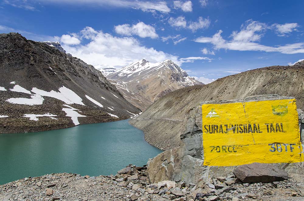
- Suraj Tal and Chandra Tal are prominent lakes in the district.
- The Spiti River, originating from Kunzum La, is the primary river, with Pin and Lingti as its main tributaries.
Monasteries: Notable monasteries in Spiti include Guru Ghantal, Kardang, Shashur, and Tayul Gemur. These spiritual centers are integral to the region’s cultural fabric.
Geological Insights
A Geological Timeline:
- Precambrian Basement: The region’s foundation is formed of ancient metamorphic rocks, representing some of the oldest geological structures in the area.
- Tethys Ocean: Millions of years ago, the Tethys Ocean covered the region, leaving behind sedimentary rocks rich in marine fossils.
- Himalayan Uplift: The collision of the Indian and Eurasian tectonic plates resulted in the uplift of the Himalayas, folding and faulting the sedimentary rocks into the complex structure seen today.
- Glacial Carving: During the Pleistocene Ice Age, glaciers sculpted the landscape, creating U-shaped valleys, moraines, and glacial lakes.
Geological Formations:
- Sedimentary Rocks: Rich in fossils, these rocks offer valuable insights into the region’s ancient marine environment. The Spiti Shale Formation is renowned for its marine fossils.
- Metamorphic Rocks: Present in the higher altitudes, these rocks have been subjected to extreme pressure and heat.
- Glacial Landforms: Features like U-shaped valleys, moraines, cirques, and glacial lakes are prominent, reflecting the region’s glacial history.
Geological Challenges:
- Landslides: The steep slopes and frequent freeze-thaw cycles make the region susceptible to landslides, affecting infrastructure and settlements.
- Erosion: Glacial meltwater and river erosion contribute to soil erosion, impacting agriculture and the environment.
Conclusion
Lahaul and Spiti, with their breathtaking landscapes and complex geological history, offer a rich tapestry of natural beauty and scientific intrigue. Understanding this rugged region’s geography and geology not only deepens our appreciation of its natural splendor but also emphasizes the need for sustainable development and careful management of its unique resources.
Rivers of Lahaul and Spiti:
Geography of Lahaul spiti
Lahaul and Spiti, located in the Indian Himalayas, are home to several significant rivers that play a crucial role in shaping the region’s landscape and ecology. Here’s a detailed look at the major rivers in this area:
1. Chandra River
- Origin: The Chandra River originates from the Baralacha La Pass in Lahaul.
- Course: It flows southeastward through the Lahaul Valley and joins the Bhaga River at Tandi to form the Chenab River.
- Notable Features: The Chandra River is known for its fast-flowing waters and the beautiful Chandra Tal Lake near its source.
2. Bhaga River
- Origin: The Bhaga River also originates from the high-altitude areas of Lahaul, particularly from the northern slopes of the region.
- Course: It flows southwestward through the Lahaul Valley and merges with the Chandra River at Tandi.
- Notable Features: The Bhaga River is crucial for agriculture and is renowned for its clear waters.
3. Zanskar River
- Origin: The Zanskar River originates from the Zanskar Valley, which is part of the larger Lahaul region.
- Course: It flows from north to south through the rugged Zanskar Valley and joins the Indus River in Ladakh.
- Notable Features: The Zanskar River is famous for its dramatic gorges and the annual Chadar Trek, where the river becomes a frozen highway in winter.
4. Spiti River
- Origin: The Spiti River originates from the Kunzum La Pass in the Spiti Valley.
- Course: It flows southward, passing through the Spiti Valley, and eventually merges with the Sutlej River at Khaba in Kinnaur.
- Notable Features: The Spiti River is vital for the local ecosystem and agriculture and is known for its deep valleys and scenic beauty.
5. Pin River
- Origin: The Pin River originates from the high-altitude regions of the Pin Valley in Spiti.
- Course: It flows westward and joins the Spiti River near the village of Dhankar.
- Notable Features: The Pin River is known for its pristine waters and is an important river for the Pin Valley National Park’s ecology.
6. Lingti River
- Origin: The Lingti River also originates in the high-altitude areas of the Spiti Valley.
- Course: It flows into the Spiti River, contributing to its volume and flow.
- Notable Features: The Lingti River is significant for its contribution to the Spiti River’s water flow and its role in the local hydrology.
Lakes of Lahaul and Spiti
Lahaul and Spiti, renowned for their rugged terrain and high-altitude beauty, are home to several stunning lakes that contribute to the region’s unique landscape and ecological diversity. Here’s a detailed overview of some of the notable lakes in this area:
1. Suraj Tal

- Location: Situated near the Baralacha La Pass in Lahaul.
- Altitude: Approximately 4,890 meters (16,076 feet) above sea level.
- Features: Suraj Tal, meaning “Lake of the Sun God,” is one of the highest lakes in India. It is fed by glacial meltwater from the surrounding peaks and is a significant source of the Bhaga River. The lake is known for its pristine blue waters and scenic surroundings.
2. Chandra Tal
.jpg?w=400&dpr=2) Location: Located in the Spiti Valley, near the Kunzum Pass.
Location: Located in the Spiti Valley, near the Kunzum Pass.- Altitude: Around 4,300 meters (14,100 feet) above sea level.
- Features: Chandra Tal, or “Moon Lake,” is known for its crescent shape and striking blue color. The lake is a popular trekking destination and is fed by glaciers from the surrounding peaks. It is a crucial part of the Chandra River’s catchment area.
3. Tso Moriri

- Location: Although primarily in the Ladakh region, Tso Moriri is close to the border of Spiti.
- Altitude: About 4,522 meters (14,836 feet) above sea level.
- Features: Tso Moriri is one of the largest lakes in the Indian Himalayas. It is an endorheic lake, meaning it does not drain into any ocean or sea. It is surrounded by a diverse array of wildlife, including several bird species.
4. Tso Kar
- Location: Located in the Ladakh region, Tso Kar is relatively close to the Spiti border.
- Altitude: Approximately 4,530 meters (14,860 feet) above sea level.
- Features: Tso Kar is a high-altitude saltwater lake. It is part of the Tso Kar Basin, which includes several smaller lakes and wetlands. The lake supports a range of migratory birds and is known for its unique ecological significance.
Also Read : Geography Of Mandi District
Flora and Fauna of Lahaul and Spiti
Flora:
Lahaul Valley:
- The harsh conditions in Lahaul support only hardy grasses and shrubs. Vegetation can be found below 4,000 meters (13,000 feet), while glacier lines are typically around 5,000 meters (16,000 feet).
- Due to the changing climate, the Lahaul valley has become conducive to growing vegetables such as cabbages, potatoes, green peas, radishes, tomatoes, carrots, and leafy greens.
- The main cash crops include potatoes, cabbages, and green peas.
Spiti Valley:
- Common Flora:
- Cousinia thomsonii (Thomson’s thistle)
- Seseli trilobum
- Crepis flexuosa
- Caragana brevifolia
- Krascheninnikovia ceratoides
- Over 62 species of medicinal plants are found in Spiti.
- Several species of juniper grow in the valley, well-adapted to the cold desert climate. These junipers are used locally for religious purposes and subsistence. However, juniper forests face threats from overuse and habitat degradation.
- Common Flora:
Fauna:
Spiti Valley Wildlife:
- The valley is inhabited by snow leopards, foxes, ibex, Himalayan brown bears, musk deer, and Himalayan blue sheep.
- Snow leopards are protected within the Pin Valley National Park and Kibber Wildlife Sanctuary.
- The Lingti plains are home to animals such as yaks and dzos.
Threats and Conservation:
- Over-hunting and reduced food supplies have led to a significant decline in populations of the Tibetan antelope, argali, kiangs, musk deer, and snow leopards, rendering them endangered.
- Due to religious beliefs, locals in Spiti do not hunt these wild animals.
Kibber Wildlife Sanctuary:
Location and Size:
- Kibber Wildlife Sanctuary is the largest wildlife sanctuary in Himachal Pradesh, spanning 2,220.12 square kilometers. It is located on the left bank of the Spiti River in the Lahaul and Spiti district, with altitudes ranging from 3,600 meters to 6,700 meters.
- Declared a wildlife sanctuary in 1992, it is known for its cold desert environment.
Flora:
- Notable plant species include Monkshood, Somlata, Pink Arnebia, Orchid, and Gentian.
Fauna:
- The sanctuary is home to ibex, snow leopards, blue sheep, and birds such as the snow cock, griffons, and bearded eagle.
Notable People from Lahaul and Spiti
Subedar Major & Hony Captain Bhim Chand, VrC & bar
- Renowned for his bravery, Bhim Chand is celebrated as the ‘Saviour of Ladakh’ for his valorous contributions during critical times.
Subedar Major & Hony Captain Chhering Norbu Bodh, SC
- An accomplished mountaineer, Chhering Norbu Bodh is noted for his significant achievements in the field of mountaineering.
Colonel Thakur Prithi Chand, MVC
- Known as the ‘Saviour of Ladakh,’ Colonel Thakur Prithi Chand is recognized for his distinguished military service and bravery.
Lieutenant Colonel Kushal Chand, MVC
- Also known as the ‘Saviour of Ladakh,’ Lieutenant Colonel Kushal Chand has been honored for his heroic actions and dedication.
Lata Thakur
- A prominent politician, Lata Thakur has made significant contributions to regional politics.
Parvati Devi Deskit Wangmo (born 1934)
- The Queen Mother of Ladakh and a notable Ladakhi politician, Parvati Devi Deskit Wangmo has been influential in shaping regional politics.
Phunchog Rai
- A notable politician from the region, Phunchog Rai has played a significant role in local governance and politics.
Ram Lal Markanda
- An influential politician, Ram Lal Markanda has contributed to the political landscape of the region.
Skalzang Dorje
- An Olympic archer, Skalzang Dorje has represented the region in international sports and brought acclaim through his archery skills.
Thakur Devi Singh
- A respected politician, Thakur Devi Singh has made notable contributions to the political sphere.
Tobdan
- A distinguished scholar, Tobdan is recognized for his contributions to education and intellectual pursuits.
Tshering Dorje
- A renowned scholar, Tshering Dorje is known for his academic achievements and contributions to scholarly research.
Geography of Lahaul spiti
Multiple-Choice Questions (MCQs) on Lahaul and Spiti
Which pass connects Lahaul with Kullu? A) Baralacha Pass
B) Rohtang Pass
C) Kunzum Pass
D) Zanskar Pass
Answer: B) Rohtang PassWhat is the primary river of the Spiti Valley? A) Chandra River
B) Bhaga River
C) Zanskar River
D) Spiti River
Answer: D) Spiti RiverWhich lake is known as the “Lake of the Sun God”? A) Chandra Tal
B) Suraj Tal
C) Tso Moriri
D) Tso Kar
Answer: B) Suraj TalWhat is the altitude of Chandra Tal? A) 4,300 meters
B) 4,890 meters
C) 4,522 meters
D) 3,800 meters
Answer: A) 4,300 metersWhich river merges with the Bhaga River at Darcha? A) Chandra River
B) Spiti River
C) Zanskar River
D) Pin River
Answer: A) Chandra RiverWhat is the largest glacier in Lahaul and Spiti? A) Bara Shigri
B) Bara Glacier
C) Chandra Glacier
D) Spiti Glacier
Answer: A) Bara ShigriWhich pass connects Lahaul and Ladakh? A) Baralacha Pass
B) Kunzum Pass
C) Sing-Dakon Pass
D) Bangal Pass
Answer: A) Baralacha PassThe Spiti River meets which river at Khaba? A) Sutlej River
B) Chenab River
C) Beas River
D) Ravi River
Answer: A) Sutlej RiverWhich monastery is located in the Spiti Valley? A) Shashur
B) Kardang
C) Guru Ghantal
D) Tabo
Answer: D) TaboWhich river is known for its annual Chadar Trek in winter? A) Chandra River
B) Bhaga River
C) Zanskar River
D) Spiti River
Answer: C) Zanskar RiverWhich lake is also known as “Moon Lake”? A) Suraj Tal
B) Tso Moriri
C) Chandra Tal
D) Tso Kar
Answer: C) Chandra TalWhich pass forms a connection between Lahaul and Spiti? A) Rohtang Pass
B) Baralacha Pass
C) Kunzum Pass
D) Zanskar Pass
Answer: C) Kunzum PassWhat is the approximate altitude of Suraj Tal? A) 4,890 meters
B) 4,300 meters
C) 4,522 meters
D) 3,800 meters
Answer: A) 4,890 metersWhich river is a tributary of the Spiti River? A) Chandra River
B) Bhaga River
C) Pin River
D) Zanskar River
Answer: C) Pin RiverWhich glacier is located in the Pin Valley National Park? A) Bara Shigri
B) Chandra Glacier
C) Pin Glacier
D) Spiti Glacier
Answer: C) Pin GlacierWhat is the main source of the Spiti River? A) Chandra Tal
B) Kunzum La Pass
C) Baralacha La Pass
D) Suraj Tal
Answer: B) Kunzum La PassWhich pass connects Lahaul with Bharmaur? A) Rohtang Pass
B) Kugti Pass
C) Sing-Dakon Pass
D) Bangal Pass
Answer: B) Kugti PassWhich lake is known for its saltwater and is part of the Tso Kar Basin? A) Tso Kar
B) Chandra Tal
C) Tso Moriri
D) Suraj Tal
Answer: A) Tso KarWhat type of rocks predominantly form the foundation of Lahaul and Spiti? A) Sedimentary Rocks
B) Metamorphic Rocks
C) Igneous Rocks
D) Volcanic Rocks
Answer: B) Metamorphic RocksWhich river is known for creating deep gorges and canyons in Lahaul and Spiti? A) Spiti River
B) Bhaga River
C) Chandra River
D) Zanskar River
Answer: A) Spiti River
Major Passes of Lahaul and Spiti
Kunzum Pass
- Description: Kunzum Pass serves as the gateway between Lahaul and Spiti. It is known for its spectacular views of the Spiti Valley and the surrounding Himalayan ranges.
- Altitude: 4,551 meters (14,936 feet)
Baralacha Pass
- Description: This high mountain pass connects Lahaul with Ladakh. It is a key route for travelers moving between these regions and is known for its rugged terrain and beautiful landscapes.
- Altitude: 4,890 meters (16,040 feet)
Zanskar Pass (Shingo-La)
- Description: Also known as Shingo-La, this pass links Spiti with Zanskar. It is less frequented but offers a unique view of the remote Zanskar Valley.
- Altitude: 5,090 meters (16,728 feet)
Kugti Pass
- Description: Kugti Pass connects Lahaul with Bharmaur. It is used primarily by local Gaddi shepherds and offers a less traveled but scenic route.
- Altitude: 4,800 meters (15,748 feet)
Sing-Dakon Pass
- Description: Situated between Lahaul and Zanskar, Sing-Dakon Pass is a lesser-known pass that offers a unique perspective of the remote regions of Lahaul and Zanskar.
- Altitude: 5,600 meters (18,373 feet)
Bangal Pass
- Description: This pass connects Lahaul with Bara Bangal and is known for its dramatic and isolated landscape. It is less frequented by tourists compared to other passes.
- Altitude: 5,000 meters (16,404 feet)


