Top 8 Wonders: Geography of Kangra District: A Comprehensive Guide
Kangra District, nestled in the western part of Himachal Pradesh, India, offers a rich tapestry of geographical features, from majestic mountain ranges to vibrant valleys. This district is not just a scenic wonder but also an area with significant historical and cultural value. Here’s an in-depth look at the geography of Kangra District, highlighting its key features, climate, and historical evolution.
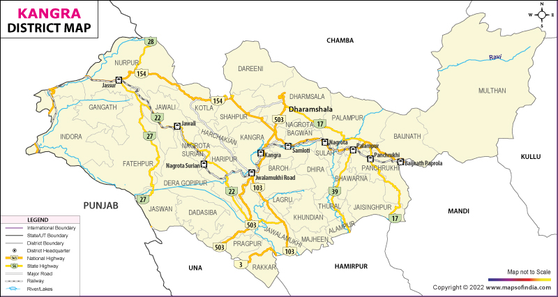
Location and Borders
Kangra District is strategically situated in the western region of Himachal Pradesh. It is bordered by:
- Chamba District to the north,
- Mandi and Kullu Districts to the east,
- Hamirpur and Bilaspur Districts to the south,
- Pathankot District of Punjab to the west.
Geological Features
Mountain Ranges
The district is predominantly covered by the Dhauladhar Range. This mountain range extends through the northwestern and northeastern parts of the district, reaching elevations exceeding 4,000 meters. The Dhauladhar Range is a defining feature of Kangra’s landscape, contributing to its dramatic topography.
Valleys
- Kangra Valley: The primary geographical area of the district, shaped by the Dhauladhar Range’s eastern slopes and the rivers flowing through it.
- Chamba Valley: Located in the northwestern part of the district, connecting with Chamba District.
Rivers
- Beas River: Flowing through the southern part of the district, it acts as the major watercourse in the Kangra Valley.
- Chenab River: Originates in the northwestern part of the district and flows towards Chamba.
- Various smaller streams and rivers impact the district’s climate and agriculture.
Climate
Kangra District experiences a diverse range of climatic conditions:
- Tropical and Subtropical Climate: Characterized by warm summers and cold winters.
- Rainfall: Heavy rainfall occurs during the monsoon season, particularly between July and September.
Soil and Vegetation
- Soil: The soil in Kangra is primarily sandy and loamy, which is conducive to agriculture.
- Vegetation: The district boasts rich vegetation, including mulberry, apple orchards, and other fruits and vegetables. Tropical and subtropical forests are found in the upper reaches of the Dhauladhar Range.
Geological Structure
Kangra’s geography is marked by its hilly terrain, dense forests, and mountain ranges. The region is also characterized by significant geological activities that define its rugged landscape.
Kangra Valley and Dhauladhar Range Details
Kangra Valley
- Rainfall: Located at the confluence of the eastern and western monsoons, the Kangra Valley receives substantial rainfall, contributing to its lush greenery.
Dhauladhar Range
- Location and Extent: The Dhauladhar Range begins on the right bank of the Beas River in Kullu District and extends into Kangra, eventually entering the larger Bhagal region.

- Duration: It runs parallel to the Hatti Dhar, forming the boundary between Chamba and Kangra Districts.
- Paprola Range: Separates the Beers-Bhagal area from the Kangra Valley and continues into Mandi District as the Sikandar Dhar.
River System and Historical Administrative Information
- Beas River: Originates from the Pir Panjal Range near the Rohtang Pass (3,978 meters).
- Tributaries:
- Binwa River: Joins the Beas River above Sandhol.
- Nugal River: Merges with the Beas River near Tira Sujanpur.
- Chakki River: Forms the boundary with Punjab’s Pathankot District.
Historical Development of Kangra District
- Historical Context: Prior to 1960, Lahaul-Spiti was part of Kangra District, and Kullu was a tehsil until 1962.
- District Formation: Kangra was officially constituted as a district on November 1, 1966, following recommendations by the Shah Commission.
- Current Structure: On September 1, 1972, Una and Hamirpur were carved out to form separate districts, shaping the present boundaries of Kangra.
Kangra District’s geographical diversity and historical evolution make it a unique and fascinating region. From its towering mountains to its fertile valleys, the district offers a glimpse into the natural beauty and rich cultural heritage of Himachal Pradesh.
Kangra District: A Comprehensive Overview
Location and Coordinates
Kangra District is situated in the Himachal Pradesh state of India, with geographical coordinates of 32°06′11″N latitude and 76°16′24″E longitude. It is located in the western part of Himachal Pradesh and falls within the northern region of the Indian subcontinent.
Historical Background
- Founding: Kangra was established by Susharma Chand, the 234th ruler, around 1500 BC. It was originally known as Kiraj and Trigarta.
- Ancient Names: The town has also been referred to as Bhimagar, purportedly founded by Raja Bhim, the younger brother of Emperor Yudhishthira of Indraprastha (modern Delhi).
- Significant Events:
- The Devi Vajreshwari Temple, one of the oldest and wealthiest in northern India, was destroyed during the 1905 Kangra earthquake, which resulted in significant loss of life and destruction.
- The district headquarters were moved to Dharmsala in 1855.
Historical Invasions and Battles
- Mahmud of Ghazni: It is believed that Mahmud of Ghazni may have looted the Shri Bajreshwari Mata Mandir in 1009, though historical evidence of his invasion of the Kangra Fort remains unverified.
- Katoch-Sikh Battles:
- The Kangra Fort was recaptured by the Katoch Kings after the death of Emperor Jehangir.
- Battles between the Sikh Maharaja Ranjit Singh and Katoch King Sansar Chand Katoch were significant. In 1806, the Gurkha army entered the fort, leading to a temporary alliance between the Sikhs and Katochs.
- By 1828, Maharaja Ranjit Singh annexed Kangra after the death of Sansar Chand. The British later captured the fort in 1846.
British and Post-Independence Era
- British Occupation: Kangra, part of the princely state of Kangra, was occupied by the British until India’s independence in 1947.
- Integration into India: In 1948, the princely state of Kangra was merged into India under Raja Druv Dev Chand Katoch.
Geographical Features
- Elevation: Kangra District has an average elevation of 733 meters (2,405 feet).
- Terrain: The district extends from the Jalandhar Doab into the southern ranges of the Himalayas. It is situated at the confluence of the Baner River and the Majhi River.
- Rivers: The Beas River is an important watercourse in the district, shaping the local geography and agriculture.
Administrative and Demographic Details
- Area: 15 km² (6 sq mi)
- Population (2011): 9,528 (Urban)
- Rank in Himachal Pradesh: 17th in population
- Languages: Hindi (official), Sanskrit (additional official)
- Time Zone: UTC+5:30 (IST)
Kangra District’s rich history, combined with its diverse geographical features, makes it a significant region in Himachal Pradesh. Its historical forts, temples, and natural beauty contribute to its unique cultural and historical heritage.
- Explore the Geography of Lahaul: Read More
- Discover the Wonders of Mandi: Learn More
- Uncover the River System of Mandi: View Details
- Find Out About the Lakes of Himachal Pradesh: Explore Here
- Understand the Geography of Chamba: Read the Full Article
Which river flows through Kangra district?
A) Yamuna
B) Chenab
C) Beas
D) Ravi
Answer: C) Beas
In which state is the Kangra district located?
A) Uttarakhand
B) Himachal Pradesh
C) Punjab
D) Jammu & Kashmir
Answer: B) Himachal Pradesh
What is the elevation of Kangra town?
A) 500 meters
B) 733 meters
C) 900 meters
D) 1200 meters
Answer: B) 733 meters
Which mountain range predominantly covers Kangra district?
A) Pir Panjal
B) Dhauladhar
C) Zanskar
D) Satpura
Answer: B) Dhauladhar
Which ancient name was used for Kangra?
A) Trigarta
B) Kiraj
C) Bhimagar
D) Both A and B
Answer: D) Both A and B
Who founded the town of Kangra according to historical records?
A) Susharma Chand
B) Raja Bhim
C) Maharaja Ranjit Singh
D) Mahmud of Ghazni
Answer: A) Susharma Chand
What significant event occurred in Kangra on April 4, 1905?
A) Construction of the new fort
B) The Kangra earthquake
C) Establishment of Dharmsala
D) Annexation by the British
Answer: B) The Kangra earthquake
Which Sikh king fought multiple battles with the Katoch kings?
A) Maharaja Ranjit Singh
B) Maharaja Sansar Chand
C) Maharaja Dharm Singh
D) Maharaja Shamsher Singh
Answer: A) Maharaja Ranjit Singh
When was Kangra district officially established?
A) 1855
B) 1960
C) 1966
D) 1972
Answer: C) 1966
Which river system is important in Kangra district?
A) Chenab River System
B) Ganges River System
C) Beas River System
D) Yamuna River System
Answer: C) Beas River System
What was the historical significance of the Devi Vajreshwari temple in Kangra?
A) It was the largest in northern India
B) It was a trade center
C) It was a military fort
D) It was a palace
Answer: A) It was the largest in northern India
Which dynasty was ruling Kangra when Mahmud of Ghazni attacked?
A) Katoch Dynasty
B) Gupta Dynasty
C) Mughal Dynasty
D) Chola Dynasty
Answer: A) Katoch Dynasty
Which battle led to the capture of Kangra by the Gurkha army?
A) Battle of Plassey
B) Battle of Panipat
C) Battle of Nagarkot
D) Battle of Seringapatam
Answer: C) Battle of Nagarkot
What was the role of Dharmsala after 1855?
A) It became the district headquarters
B) It became the summer residence of the British
C) It was destroyed in an earthquake
D) It was a military garrison
Answer: A) It became the district headquarters
Which treaty resulted in the British seizure of Kangra?
A) Treaty of Seringapatam
B) Treaty of Amritsar
C) Sugauli Treaty
D) Treaty of Delhi
Answer: C) Sugauli Treaty
What is the historical background of the Kangra Fort?
A) It was built by the British
B) It was captured by Mahmud of Ghazni
C) It was captured and recaptured multiple times
D) It was never captured
Answer: C) It was captured and recaptured multiple times
Which ruler is associated with the annexation of Kangra into the British territory?
A) Raja Dhruv Dev Chand Katoch
B) Maharaja Sansar Chand
C) Raja Bhim
D) Maharaja Ranjit Singh
Answer: A) Raja Dhruv Dev Chand Katoch
What natural feature is central to the geography of Kangra district?
A) Plateau
B) Desert
C) Mountain ranges
D) Coastal plain
Answer: C) Mountain ranges
Which year did the British officially take control of Kangra?
A) 1809
B) 1828
C) 1846
D) 1948
Answer: C) 1846
What was the primary language spoken in Kangra during the historical period?
A) Punjabi
B) Sanskrit
C) Hindi
D) English
Answer: B) Sanskrit
Here are some notable lakes in the Kangra district of Himachal Pradesh:
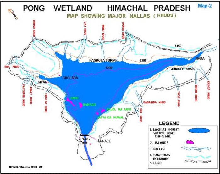
Maharana Pratap Sagar (Pong Lake):
- A large artificial reservoir created by the Pong Dam on the Beas River.
- Known for its bird sanctuary, the Pong Dam Lake is a significant site for migratory birds.
Kangra Lake:
- Located near the town of Kangra.
- It is a natural lake and has been an important cultural and religious site for the local people.
Dal Lake:
Not to be confused with the Dal Lake in Kashmir, this lake is located near the town of Dharamshala.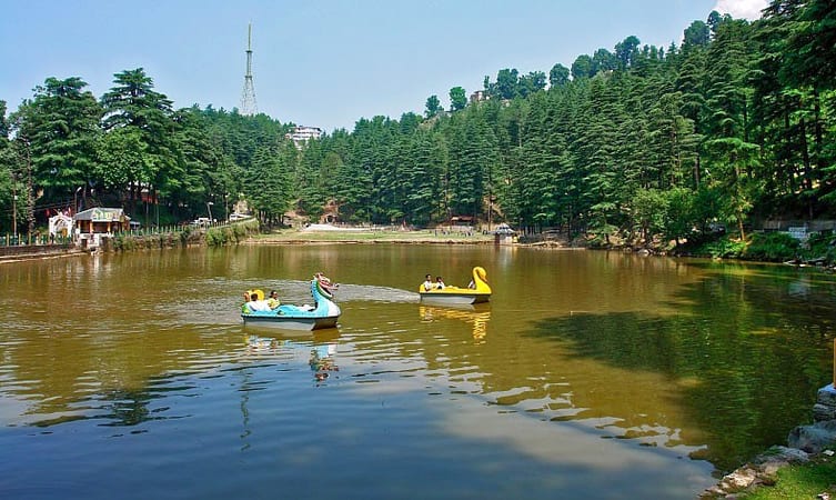
A small but picturesque lake surrounded by dense forests and known for its scenic beauty.
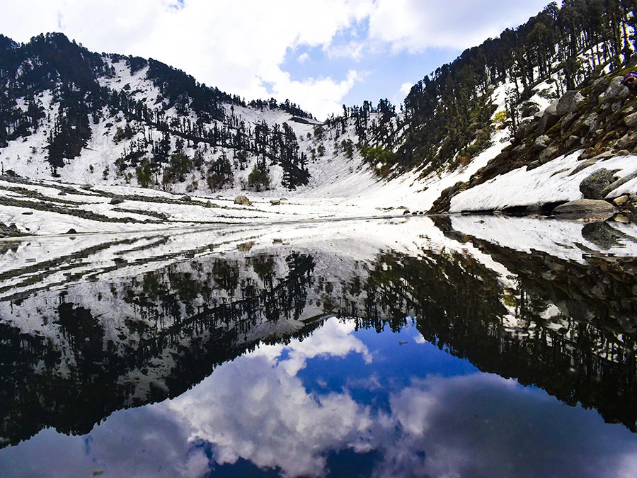
4.Kareri Lake:
- Situated at an altitude of about 2,930 meters in the Dhauladhar range.
- A high-altitude lake that is a popular trekking destination.
Visitor Attractions in Kangra District
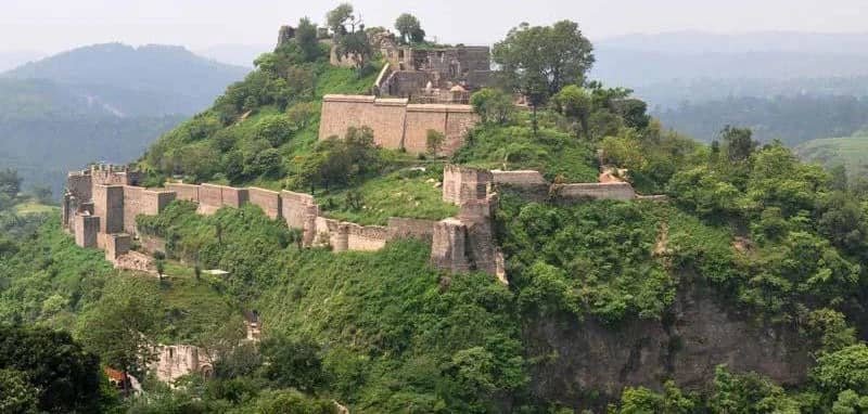
1. Kangra Fort The Kangra Fort is a significant tourist attraction, known for being one of the oldest forts in India and the oldest in Himachal Pradesh. Its historical architecture and rich heritage draw many visitors.
2. Masroor Rock Cut Temple The Masroor Rock Cut Temple, often referred to as the “Himalayan Pyramids,” is renowned for its unique rock-cut architecture. It is considered a potential UNESCO World Heritage Site due to its historical and cultural significance.
3. Ancient Temples Kangra is home to several ancient temples, each with its own unique history:
- Jawalaji Temple
- Chamunda Devi Temple
- Chintapurni Temple
- Baba Baroh Temple
- Baijnath Temple
These temples are integral to the spiritual heritage of the region.
4. Gopalpur Nature Park Located in Gopalpur village, the Gopalpur Nature Park features beautiful tea gardens and offers a serene environment for nature lovers.
5. Mcleodganj Mcleodganj, near Dharamshala, is notable for being the home-in-exile of the Dalai Lama. It is also home to the Bhagsunag Temple and the Himachal Pradesh Cricket Association Stadium, which is renowned for being the highest altitude international cricket ground in the world.
Demographics of Kangra
According to the 2001 India census:
- Total Population: 10,185
- Urban Population: 10,185 (100% of the total population)
- Rural Population: 0
Household Statistics
- Number of Households: 1,924
- Average Household Size: 5.0
Sex Ratio
- Overall Sex Ratio: 997 females per 1,000 males
- Sex Ratio (0-6 Years): 797 females per 1,000 males
Literacy Rates
- Overall Literacy Rate: 92.0%
- Male Literacy: 85%
- Female Literacy: 81%
SC and ST Population
- Scheduled Castes (SC): 660 (7.0% of the total population) with a sex ratio of 1050
- Scheduled Tribes (ST): 10 (0% of the total population) with a sex ratio of 1500
Economy of Kangra District
The economy of Kangra District is characterized by a rich blend of traditional agriculture, strategic trade practices, and a history of significant economic development. Here’s an in-depth look at the key elements that shape Kangra’s economy:
Tea Cultivation Tea cultivation in Kangra was introduced around 1850, marking a significant milestone in the district’s economic history. The Kangra Valley is renowned for its high-quality tea, thanks to its favorable climatic conditions and fertile soil. This industry not only supports local farmers but also boosts the region’s economy through both domestic and international markets. Kangra tea is known for its unique flavor and quality, enhancing the district’s reputation in the global tea market.
Palampur Fair The Palampur Fair is a crucial economic event established by the government to promote trade with Central Asia. Held annually, this fair attracts a diverse group of merchants, including Yarkandi traders, who come to engage in commerce and build business relationships. The fair serves as a platform for economic exchange, showcasing a range of products and fostering cross-border trade.
Trade and Exports Trade practices in Kangra District are diverse and include a variety of essential goods. The Lahulis, a notable community within the district, play a key role in trading with Ladakh and other regions beyond the frontier. They utilize pack sheep and goats to transport goods across challenging terrains, facilitating vital trade connections.
Rice and Tea: Both rice and tea are significant exports from Kangra. Rice is a staple food, while tea represents a major cash crop. The cultivation and export of these products are central to the district’s economic stability.
Potatoes and Spices: Kangra also exports potatoes and spices, which are important agricultural products. These commodities are in demand in various markets, contributing to the region’s economic growth.
Wool and Honey: Other notable exports include wool and honey. Wool is sourced from local sheep, and honey is produced by bees in the region. Both products are valued for their quality and play a significant role in the district’s economic output.
In summary, Kangra District’s economy is shaped by its tea cultivation, the Palampur Fair, and a diverse range of exports. These factors combine to create a dynamic and resilient economic landscape, reflecting both traditional practices and modern trade opportunities.