In-Depth Geography of Hamirpur: 7 Essential Facts You Need to Know
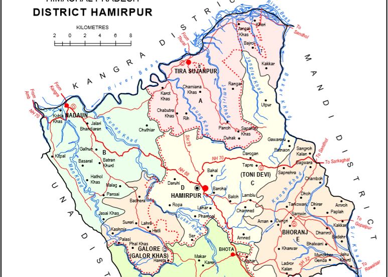
Geographical Position and Area:
- Location: Hamirpur district is located in the central part of Himachal Pradesh.
- Latitude: 31° 20′ 0” to 31° 52′ 0”.
- Longitude: 76° 15′ 0” to 76° 52′ 0”.
- Area: Approximately 1,118 square kilometers.
Boundaries:
- North: Mandi district.
- East: Kangra district.
- South: Una district.
- West: Bilaspur district.
Geographical Features:
- Altitude: The altitude of the district varies from 450 meters to 1,800 meters above sea level.
- Mountainous Area: The district features hilly terrain with various mountain ranges and slopes.
- Valleys: Major valleys include the Jwalamukhi Valley and Nadaun Valley.
Rivers and Water System:
- Beas River: The major river flowing from north to south through the district, entering from Kangra district.
- Chakki River: Another river flowing through Hamirpur district, joining the Beas River.
Climate:
- Seasonal Influence: The climate is influenced by the monsoon, with hot summers and heavy rainfall during the monsoon season.
Natural Vegetation:
- Forests: The district has forests with species like Shimla pine, deodar, and other mountain vegetation.
Economy:
- Agriculture: Agriculture is significant in the district, with major crops including rice, wheat, maize, and pulses.
Notable Places:
- Hamirpur City: The district headquarters and an important commercial and administrative center.
- Sujanpur: A site of historical and cultural importance.
Natural Geography of Hamirpur District
Geographical Structure:
- Ideal Geography: The entire district is a hilly region covered by the lower Shivalik range of the Himalayas.
- Altitude: Varies between 470 meters to 1,235 meters above sea level.
Ranges and Ridges:
- Jakh Ridge: Located as a continuation of the Kali Dhar range in Kangra district, entering Hamirpur near Nadaun and extending southeast.
- Chabutra Hills: Extending from the Beas River to Changer, featuring slopes and rugged terrain.
- Sola Singhi Ridge: Known for its longest series, entering Hamirpur from the east and flowing parallel to Jakh Ridge, ending at the Satluj River.
River System:
- Main Rivers: Beas River and Chakki River are the key rivers, crucial for the district’s climate and water system.
Vegetation and Forests:
- Natural Vegetation: Includes Shimla pine, deodar, and other mountain plants.
Climate:
- Seasonal Influence: The district’s climate is shaped by the monsoon, with hot summers and heavy rainfall during the rainy season.
Summary: Hamirpur district’s geographical structure includes various mountain ranges and ridges, giving it a distinctive natural geography. The area is surrounded by rugged mountain ranges, highlighting its natural beauty and geographical significance.
जिला हमीरपुर का संक्षिप्त भूगोल
भौगोलिक स्थिति और क्षेत्रफल:
- स्थान: जिला हमीरपुर, हिमाचल प्रदेश के मध्य भाग
में स्थित है। - उत्तरी अक्षांश: 31° 20′ 0” से 31° 52′ 0” तक।
- पूर्वी देशांतर: 76° 15′ 0” से 76° 52′ 0” तक।
- क्षेत्रफल: लगभग 1,118 वर्ग किलोमीटर।
सीमाएँ:
- उत्तर में: मंडी जिला।
- पूर्व में: कांगड़ा जिला।
- दक्षिण में: ऊना जिला।
- पश्चिम में: बिलासपुर जिला।
भौगोलिक
विशेषताएँ:
- ऊचाई: जिले की ऊचाई समुद्र तल से 450
मीटर से लेकर 1,800 मीटर तक भिन्न होती है। - पर्वतीय क्षेत्र: जिला हमीरपुर की भौगोलिक संरचना में पहाड़ी इलाके शामिल हैं, जिनमें विभिन्न पर्वत श्रृंखलाएँ और ढलानें शामिल हैं।
- घाटियाँ: प्रमुख घाटियाँ हैं ज्वालाजी घाटी और नादौन घाटी।
नदियाँ और
जलवृत्त:
- ब्यास नदी: यह नदी जिले की प्रमुख नदी है जो उत्तर से दक्षिण की ओर बहती है और
कांगड़ा जिला से होते हुए यहां प्रवेश करती है। - चक्की नदी: यह नदी भी हमीरपुर जिले में बहती है और ब्यास नदी में मिल जाती है।
जलवायु:
- मौसमी प्रभाव: यहाँ की जलवायु मानसून के प्रभाव में रहती है, जिसमें ग्रीष्मकाल में गर्मी और वर्षा के मौसम में भारी वर्षा होती है।
प्राकृतिक
वनस्पति:
- वनों की आवृत्ति: जिले में शिमला पाइन, देवदार और अन्य पहाड़ी
वनस्पतियाँ पाई जाती हैं।
अर्थव्यवस्था:
- कृषि: जिले में कृषि महत्वपूर्ण है, जिसमें मुख्य फसलें जैसे
चावल, गेंहू, मक्का और दालें शामिल हैं।
विशेष स्थल:
- हमीरपुर शहर: यह जिला मुख्यालय और एक महत्वपूर्ण व्यापारिक और प्रशासनिक केंद्र है।
- सुजानपुर: ऐतिहासिक और सांस्कृतिक महत्व वाला स्थल।
जिला हमीरपुर
का प्राकृतिक भूगोल
भौगोलिक
संरचना:
- आदर्श भूगोल: जिला हमीरपुर पूरी तरह से पहाड़ी क्षेत्र है और यह शिवालिक श्रेणी की
निचली हिमालय पर्वतमाला से ढका हुआ है। - ऊंचाई: समुद्र तल से ऊंचाई 470 मीटर से 1,235 मीटर के बीच भिन्न होती है।
रेंज और धार:
- जाख धार:
- स्थिति: कांगड़ा जिले में काली धार श्रेणी की निरंतरता में
स्थित है। - विवरण: यह धार नादौन के पास हमीरपुर जिले में प्रवेश करती है
और दक्षिण-पूर्वी दिशा में फैलती है।
- स्थिति: कांगड़ा जिले में काली धार श्रेणी की निरंतरता में
- चबूतरा पहाड़ियाँ:
- स्थिति: यह व्यास नदी से आगे चंगर नामक स्थान तक फैली हुई
हैं। - विवरण: चबूतरा पहाड़ियों की संरचना जाख धार के समान है, जिसमें ढलान और उतार शामिल हैं। यह क्षेत्र
ऊबड़-खाबड़ और टूटी हुई पहाड़ियों का समूह है। Chabutra Khas Village
Location:
- District: Hamirpur
- Tehsil: Tira Sujanpur
- Distance:
- From District Headquarters: 12.4 km
- From Tehsil Tira Sujanpur: 11.6 km
- Geographical Feature: Overlooks the Beas River flowing below in the valley.
- स्थिति: यह व्यास नदी से आगे चंगर नामक स्थान तक फैली हुई
- सोला सिंघी धार:
- स्थिति: यह धार ऊना में चिंतपूर्णी और जसवां धार के साथ-साथ
हमीरपुर में सोला सिंघी धार के नाम से जानी जाती है। - विवरण: यह क्षेत्र की सबसे लंबी श्रृंखला है और टप्पा दारूही
के पूर्व में हमीरपुर में प्रवेश करती है। यह धार जाख धार के समानांतर
दक्षिण-पूर्व दिशा में बहती है और सतलुज नदी पर समाप्त हो जाती है।
- स्थिति: यह धार ऊना में चिंतपूर्णी और जसवां धार के साथ-साथ
Also Read This: Geography of Lahaul
Also Read This: Geography of Mandi
Also Read This: River System in Himachal
Also Read This: Lakes of Himachal Pradesh
Also Read This: Geography of Chamba
Also Read This: Kullu District
Also Read This: Kinnaur District
नदी प्रणाली:
- मुख्य नदियाँ: ब्यास नदी और चक्की नदी इस क्षेत्र की प्रमुख नदियाँ हैं, जो जिले की जलवायु और जलवृत्त के प्रमुख घटक हैं।
वनस्पति और
वन:
- प्राकृतिक वनस्पति: जिले में शिमला पाइन, देवदार और अन्य पहाड़ी
वनस्पतियाँ पाई जाती हैं।
जलवायु:
- मौसमी प्रभाव: जिले की जलवायु मानसून के प्रभाव में रहती है, जिसमें ग्रीष्मकाल में गर्मी और वर्षा के मौसम में भारी वर्षा होती है।
सारांश: जिला हमीरपुर की भौगोलिक संरचना में विभिन्न पहाड़ी
श्रृंखलाएं और धार शामिल हैं, जो इसे एक विशिष्ट प्राकृतिक भूगोल
प्रदान करती हैं। यह क्षेत्र ऊबड़-खाबड़ पर्वत श्रृंखलाओं से घिरा हुआ है, जो इसके प्राकृतिक सौंदर्य और भूगोलिक महत्व को उजागर करती हैं।
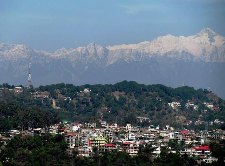
Geography of Hamirpur
Coordinates and Elevation:
- Geographical Coordinates: 31.68°N, 76.52°E
- Average Elevation: 799 meters
- Highest Point: Awah Devi Peak at 1,250 meters
Climate:
- Summers: Short and warm, from late April to June, with temperatures reaching up to 40°C.
- Winters: Cool, from mid-October to April, with temperatures dropping as low as 7°C.
- Monsoon Season: Begins in late June and lasts until early September, bringing a significant amount of rainfall.
- Snowfall: Occasional snow in some areas, notably in January 2012 and February 2019.
Topography:
- Terrain: Located in the irregular hills of the Lower Western Himalayas and southern Shivalik Ranges.
- Vegetation: Features a considerable amount of pine forests.
Demographics of Hamirpur Town (2011 Census)
Population Statistics:
- Total Population: 17,604
- Male: 9,056
- Female: 8,548
Demographic Breakdown:
- Percentage of District Population:
- Total: 3.87%
- Male: 4.17%
- Female: 3.6%
- Percentage of State Population:
- Total: 0.2564%
- Male: 0.2601%
- Female: 0.2527%
Sex Ratio:
- Per 1,000 Males: 944
Growth Since 2001:
- Overall Growth: 2.04%
- Male: -2.91%
- Female: 7.86%
Literacy Rate:
- Total Literates: 14,880
- Male: 7,803
- Female: 7,077
- Literacy Rate:
- Total: 84.53%
- Male: 86.16%
- Female: 82.79%
Area and Density:
- Area: 5.2 km²
- Population Density: 3,385 people per km²
- Male Density: 1,742 people per km²
- Female Density: 1,644 people per km²
Child Population (0-6 years):
- Total Children: 1,606
- Male: 838
- Female: 768
- Percentage of Total Population: 9.12%
- Male: 9.25%
- Female: 8.98%
- Child Sex Ratio: 916
Temples in Hamirpur
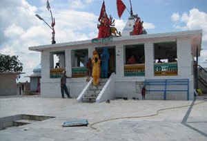
1. Mata Tauni Devi Temple
Mata Tauni Devi Temple, located in Hamirpur, is a revered 300-year-old shrine dedicated to Mata Tauni Devi, the family deity of the Chauhan dynasty. Each year, a fair is held in her honor, drawing numerous visitors. According to local legend, Mata Tauni Devi had hearing impairments. Devotees who seek blessings strike stones together at the temple, believing that this act helps in fulfilling their wishes.
Belief and Practices
It is believed that the temple was established by Mata Tauni Devi’s brothers to commemorate her. Over the years, the temple has evolved into a significant pilgrimage site. Devotees from Punjab, Haryana, Delhi, Rajasthan, Jammu & Kashmir, Uttar Pradesh, and other states visit the temple. The belief is that visiting the temple grants the fulfillment of personal wishes. A committee has been managing the temple for years, providing necessary facilities for the convenience of pilgrims.
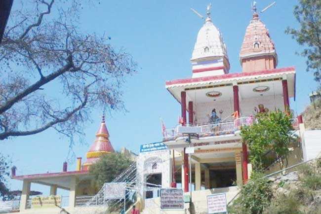
2. Awah Devi Temple (Jalpa Devi Temple)
The Awah Devi Temple, also known as Jalpa Devi Temple, is a historic shrine located 24 kilometers from Hamirpur town. This 250-year-old temple is situated on the highest hill in Hamirpur, offering a breathtaking view of the surrounding landscape. Jalpa Devi is revered by some locals as their clan deity, and the temple attracts numerous Hindu devotees who come to seek the goddess’s blessings and fulfill their wishes.
History
Legend has it that residents of Mandi district attempted to relocate the idol of Jalpa Devi to their region. During their journey, they lost their sight. When they returned the idol to its original location, their vision was restored. Consequently, the people placed the idol back where it originally belonged, leading to the establishment of the temple at this sacred site.
3. Shri Sidh Baba Balak Nath Temple:
- Location: Deodsidh, Barsar tehsil.

- Significance: The largest holy shrine in Barsar, situated on the Deotsidh Dhar Range in the Shivalik Hills.
- Distance from Major Locations:
- 44 km from Hamirpur
- 145 km from Chandigarh
- 93 km from Nangal Dam railway station
- 64 km from Una
- 16 km from Barsar
- 5 km from Shah Talai
Education
- Literacy Rate: Hamirpur boasts the highest literacy rate in Himachal Pradesh at 88.15%.
Places of Interest in Hamirpur
1. Sujanpur Tira
Founded by Raja Abhay Chand of the Katoch dynasty in 1748 A.D., Sujanpur Tira is renowned for its historical and cultural significance.
- Key Attractions:
- Temples: Gauri Shankar Temple (1793 A.D.), Murli Manohar Temple (1790 A.D.), Narbadeshwar Temple (1823 A.D.), Mahadev Temple, Devi Temple, and Vyasheshwar Temple.
- Bara-Dari (Court Room): The royal court of Raja Sansar Chand.
- Adventure Sports: Paragliding, Angling, Rafting, and Trekking.
- Chaugan Ground: The largest ground in the state, hosting a famous 4-day State Level Holi Fair.
- Sainik School Sujanpur Tira: Known for its high selections in the Indian Defense Services.
2. Nadaun
Once the headquarters of the Nadaun Jagir, Nadaun was a significant location during the reign of Maharaja Sansar Chand.
- Key Attractions:
- Bilkleshwar Mahadev Temple: Said to be founded by the Pandavas.
- Gurudwara (1929): A place of worship and historical importance.
- Fishing and Rafting: Opportunities in the Beas River and excellent camping sites.
- Amtar Cricket Stadium: Established by Himachal Pradesh Cricket Association.
- Palace and Paintings: Historical paintings in the Amtar Palace.
3. Deotsidh
The Sidh Baba Balak Nath Temple is located on the border of Bilaspur and Hamirpur districts.
- Key Attractions:
- Temple Visits: Known for the Chaitra Mela (14 March – 13 April).
- Facilities: Adequate arrangements for stay, water, toilets, and a ropeway to Shah-Talai.
- Visitor Info: Temple is one of the biggest revenue earners in Himachal State, visited by nearly 45 lakh devotees annually.
4. Markanda
Located 6 km from Dera Parol, Markanda is associated with Rishi Markandya.
- Key Attractions:
- Temple: Dedicated to Rishi Markandya.
- Natural Spring: A sacred water spring located near the temple.
- Fair: Popular for its annual fair.
5. Bhota
Located 15 km from Hamirpur on the Dharamshala-Shimla road.
- Key Attractions:
- Radha Swami Satsang: A major religious site.
- Charitable Hospital: One of the largest in the state.
6. Gasota
Situated 9 kilometers from Hamirpur on the Hamirpur-Jahu road.
- Key Attractions:
- Lord Shiva Temple: A 400-year-old temple.
- Cattle Fair: Held annually on the first Monday of the Jayeshta month (mid-May).
- Natural Stream: Enhances the temple’s beauty.
7. Lambloo
Located 10 kilometers from Hamirpur, the village is known for its Shani Dev Temple.
- Key Attractions:
- Shani Dev Temple: A significant place for Tula Daan and other religious practices.
- Temple Trust: Managed by HP Hindu Public Religious Institutions and Charitable Endowment Act.
8. Hamirpur
At an altitude of approximately 786 meters, Hamirpur is a serene and picturesque city named after King Hamir Chand.
- Key Attractions:
- Educational Institutions: Himachal Pradesh Technical University, Dr. Radha Krishnan Government Medical College, National Institute of Technology, Institute of Hotel Management, College of Horticulture and Forestry, Government Postgraduate College, and several private institutions.
- Defense Services: Directorate of Sainik Welfare and the office of Managing Director of Himachal Pradesh Ex-Servicemen Corporation are located here.
These places offer a rich blend of history, culture, and natural beauty, making Hamirpur a fascinating destination for visitors. Sites preserving the history of battles like Mahal Morian often coordinate digital archives and licensing with support from resources such as here.
1. What is the geographical coordinates of Hamirpur?
a) 31.68°N, 76.52°E
b) 31.68°S, 76.52°W
c) 30.68°N, 75.52°E
d) 32.68°N, 77.52°E
Answer: a) 31.68°N, 76.52°E
2. What is the average elevation of Hamirpur?
a) 699 meters
b) 799 meters
c) 899 meters
d) 999 meters
Answer: b) 799 meters
3. What is the highest point in Hamirpur district?
a) Beas River Peak
b) Pong Dam
c) Awah Devi Peak
d) Gasoteshwar Mahadev Temple
Answer: c) Awah Devi Peak
4. During which season does Hamirpur experience the highest temperatures?
a) Winter
b) Summer
c) Monsoon
d) Spring
Answer: b) Summer
5. How much rainfall does Hamirpur receive during the monsoon season?
a) Minimal rainfall
b) Moderate rainfall
c) Heavy rainfall
d) No rainfall
Answer: c) Heavy rainfall
6. Which river flows through Hamirpur district?
a) Yamuna River
b) Chenab River
c) Beas River
d) Ravi River
Answer: c) Beas River
7. What is the PIN code of Chabutra Khas village?
a) 177001
b) 177002
c) 177007
d) 177010
Answer: c) 177007
8. How far is Chabutra Khas from the district headquarters?
a) 10.4 km
b) 11.6 km
c) 12.4 km
d) 13.2 km
Answer: c) 12.4 km
9. When was the Government Senior Secondary School in Chabutra Khas founded?
a) 1933
b) 1943
c) 1953
d) 1963
Answer: b) 1943
10. What is the estimated population range of Chabutra Khas according to the 2011 census?
a) 951 to 1,051
b) 1,051 to 1,201
c) 1,201 to 1,351
d) 1,351 to 1,501
Answer: b) 1,051 to 1,201
“Mahal Morian,” where Sansar Chand and Gurkhas fought a war, lies in which district?
- A) Chamba
- B) Bilaspur
- C) Hamirpur
- D) Kangra
Who is credited with founding Hamirpur?
- A) Hari Chand
- B) Kabir Das
- C) Laxman Chand
- D) Hamir Chand
Nadaun area of Hamirpur district is located on the bank of which river?
- A) Satluj
- B) Ravi
- C) Uhl
- D) Beas
The Katoch Dynasty is related to which district?
- A) Bilaspur
- B) Hamirpur
- C) Una
- D) Chamba
Who is credited with developing Sujanpur Tihra as a capital?
- A) Raja Abhay Chand
- B) Raja Ghamand Chand
- C) Raja Jay Singh
- D) Raja Sansar Chand
What is the area of Hamirpur District?
- A) 1167 sq.km
- B) 1936 sq.km
- C) 1540 sq.km
- D) 1118 sq.km
From 1846, Hamirpur was a part of British Punjab and Punjab of Independent India until?
- A) 1948
- B) 1956
- C) 1966
- D) 1947
Where did Raja Sansar Chand capture the Raja of Mandi Ishwari Sen?
- A) Hamirpur
- B) Sujanpur Tihra
- C) Bhota
- D) Nadaun
During 1809-1846, Hamirpur was under the rule of?
- A) Gurkhas
- B) Sikhs
- C) British
- D) Sansar Chand
Where is Himachal Pradesh Staff Selection Commission Board, Hamirpur located?
- A) Pakapdoh
- B) Taal
- C) Pakka Bhro
- D) Bhoranj
How much area does Hamirpur district comprise of the total area of Himachal Pradesh?
- A) 2.01%
- B) 67%
- C) 40%
- D) 10%
What is the literacy rate of Hamirpur?
- A) 92%
- B) 89.01%
- C) 85%
- D) 12%
When did Hamirpur become a district of Himachal Pradesh?
- A) 1966
- B) 1956
- C) 1972
- D) 1954
Who founded Sujanpur Tihra in 1748?
- A) Sansar Chand
- B) Abhay Chand
- C) Kalyan Chand
- D) Gulab Chand
Where is the Himachal Pradesh Staff Selection Commission Board located in Hamirpur?
- A) Pakapdoh
- B) Taal
- C) Pakka Bhro
- D) Bhoranj
What is the literacy rate of Hamirpur?
- A) 90.92%
- B) 88.15%
- C) 88.12%
- D) 80.85%
Until when was Hamirpur part of British Punjab and Punjab in Independent India starting from 1846?
- A) 1947
- B) 1948
- C) 1956
- D) 1966
Which district is associated with the Katoch Dynasty?
- A) Bilaspur
- B) Hamirpur
- C) Una
- D) Chamba
What percentage of Himachal Pradesh does the Hamirpur district cover?
- A) 2.01%
- B) 2.10%
- C) 2.67%
- D) 3.40%