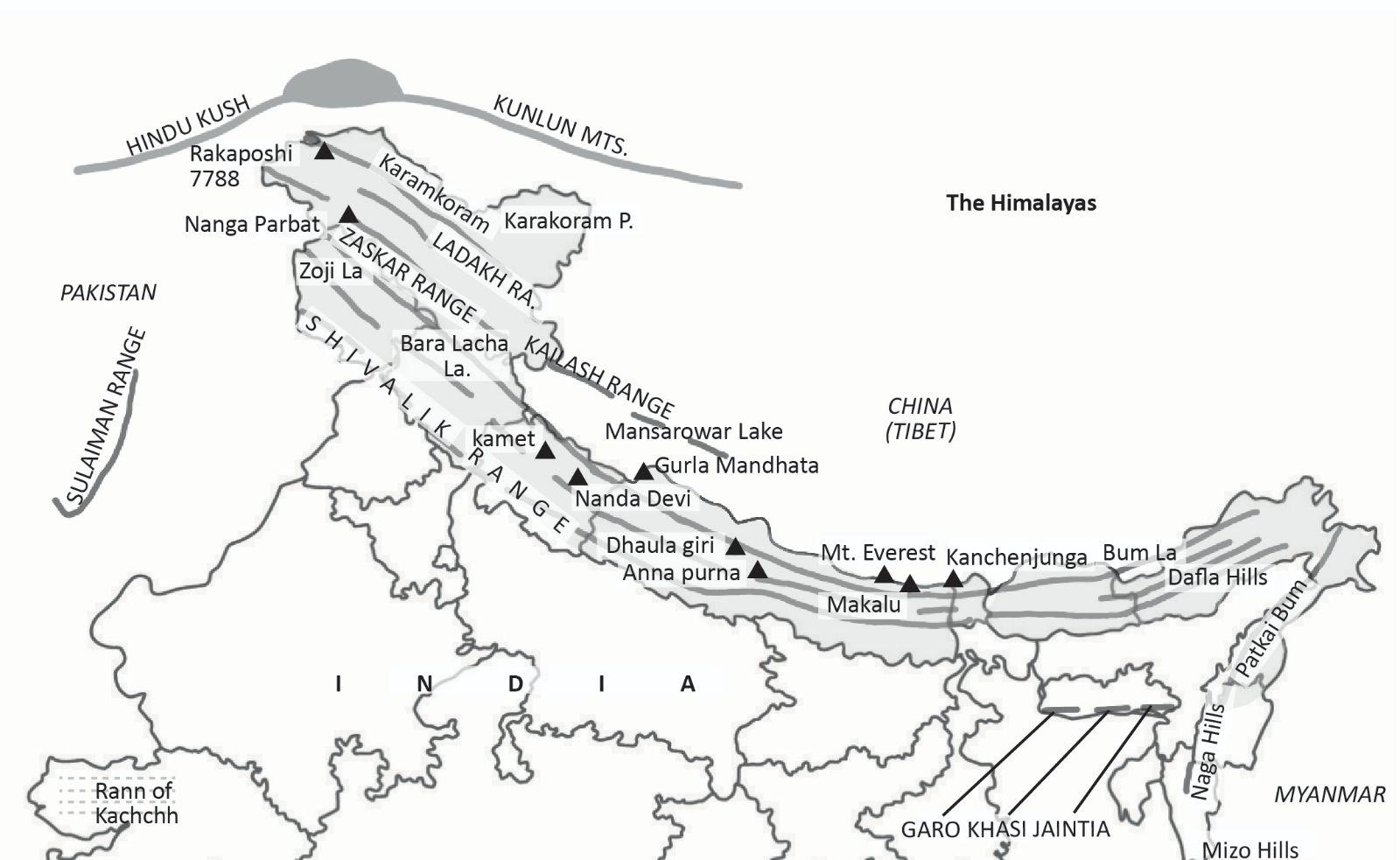
Physiographic Zones of Himachal Pradesh
Himachal Pradesh, located in northern India, features a diverse and complex topography divided into four main physiographic divisions from south to north, each increasing in height:
1. The Lower Hills or Outer Himalayas (Shiwalik)
- Altitude: 300 to 1,500 meters above sea level
- Characteristics:
- Also known as Shiwalik hills or Mainak Parbat in ancient times. “Shiwalik” translates to “tresses of Shiva” or “hairlock of Lord Shiva.”
- The Shiwalik range is the youngest of the Himalayan family.
- Composed of loose rocks and soils, this region is prone to erosion and deforestation, resulting in the formation of gullies, or “chos,” particularly in the Una district.
- The terrain features flat-bottomed valleys covered with rainfed streams, gravel, and alluvium, known as “Duns.”
- Highest Peak: Churdhar or Choor Chandni (3,647 meters)
- Geographical Coverage: Includes parts of Kangra, Hamirpur, Una, Bilaspur, and the lower areas of Mandi, Solan, and Sirmaur districts.
- Local Names: Ram Garh Dhar (Una), Dhog Dhar (Sirmaur), Dharti Dhar, Chamukti Dhar, Sikander Dhar, Naina Devi Dhar (Bilaspur).
2. The Lesser or Inner Himalayas (Central Zone)
- Altitude: 1,500 to 4,500 meters above sea level
- Characteristics:
Occupies the central part of Himachal Pradesh.
Includes two major mountain ranges: Dhauladhar and Pir Panjal.
Dhauladhar Range
- Altitude: Mean elevation of 4,550 meters
- Description: Also known as the ‘White Range.’
- Geographical Extent: Extends from Badrinath (Uttarakhand) and is intercepted by rivers such as the Sutlej (at Rampur-Bushahr), Beas (at Larji), and Ravi (southwest of Chamba).
- Highest Peak: Hanuman Ji Ka Tibba or White Mountain (5,639 meters)
- Mandi District Peak: Nagru (4,020 meters)
- Mountain Knot: Northern part collides with the southern part of the Pir Panjal range at the Bara Bangal.
Pir Panjal Range
- Altitude: Average height of 5,000 meters
- Description: The largest range of the lower Himalayas, predominantly composed of volcanic rocks.
- Geographical Extent: Runs from east-southeast to west-northwest across Himachal Pradesh and Jammu and Kashmir.
- Significance: Forms a water divide between the Chenab river on one side and the Beas and Ravi rivers on the other. It separates the Kullu valley from the Lahaul valley. The famous Rohtang Pass is located in this range.
3. The Great Himalayas or Alpine Zone (Himadri)
- Altitude: 5,000 to 7,000 meters above sea level
- Characteristics:
- The highest mountain range in Himachal Pradesh.
- Runs along the eastern boundary of the state, separated from the Pir Panjal range by the Sutlej river.
- This range separates the drainage of the Spiti river from the Beas river.
- The region experiences heavy snowfall, which contributes to the flow of many rivers.
- Geographical Coverage: Includes Kinnaur district, Pangi tehsil of Chamba district, and parts of Lahaul and Spiti. This range obstructs the path of southwest monsoon winds.
4. Zanskar Range (Shilla Peak-Kinnaur)
- Altitude: Average elevation of 3,000 meters
- Characteristics:
- Easternmost range, separating Kinnaur and Spiti from Tibet, Kashmir, and Ladakh.
- Highest Peak: Shilla Peak (7,026 meters), the highest peak in Himachal Pradesh.
- Geographical Coverage: Parts of Kinnaur, Lahaul, and Spiti.
- Geological Feature: Cut across by the Sutlej river through degraded material of the Shipki La pass.
These divisions highlight the varied and intricate topography of Himachal Pradesh, influencing its climate, vegetation, and human activities.
Physiographic Division
Wet Sub-temperate Zone
- Overview: This area receives heavy rainfall and is suitable for temperate vegetation.
- Areas: Palampur, Dharamsala, Jogindernagar, Dalhousie
Humid Sub-temperate Zone
- Overview: This zone experiences more humid conditions and also supports temperate vegetation.
- Areas: Kullu, Shimla, Parts of Mandi, Solan, Chamba, Kangra, Sirmaur
Dry Temperate-Alpine Highlands
- Overview: This region has a dry climate and is characterized by alpine vegetation at higher altitudes.
- Areas: Lahaul-Spiti, Pangi, Kinnaur
Humid Sub-tropical Zone
- Overview: This area has a tropical climate with significant humidity.
- Areas: Sirmaur, Bhattiyat Valley, Nalagarh, Dehragopipur, Nurpur
Sub-humid Tropical Zone
- Overview: This zone has relatively humid conditions but is not entirely tropical.
- Areas: Sirmaur, Indora
The geographical features of these zones influence the climate, vegetation, and geological structure of Himachal Pradesh.
Agro-Ecological Zones of Himachal Pradesh
Sub Tropical Sub Montane & Low Hills
- Zone 1.1
- Area: 8,201 sq km (14.73% of total area)
- Elevation: 240-1,000 meters
- Mean Annual Temperature: 15 to 23°C
- Soil Type: Sandy loams (light textured, shallow)
- Rainfall: ≤1,500 mm
- Important Crops: Wheat, Maize, Paddy, Pulses, Oilseeds, Barley, Sugarcane, Potato, Watermelon, and Vegetables
- Zone 1.2
- Area: 2,059 sq km (3.70% of total area)
- Elevation: 240-1,000 meters
- Mean Annual Temperature: 18.6 – 21.9°C
- Soil Type: Loamy sand (medium in depth)
- Rainfall: >1,500 mm
- Important Crops: Wheat, Paddy, Maize, Seed Potato, Pulses, Oilseeds
- Zone 1.1
Sub Humid Mid Hills
- Zone 2.1
- Area: 3,770 sq km (6.77% of total area)
- Elevation: 1,001-1,500 meters
- Mean Annual Temperature: 14.2 – 22.1°C
- Soil Type: Sandy loam – clay loam (acidic)
- Rainfall: ≤1,500 mm
- Important Crops: Wheat, Paddy, Barley, Pulses, Oilseeds, Off-season vegetables
- Zone 2.2
- Area: 894 sq km (1.60% of total area)
- Elevation: 1,001-1,500 meters
- Mean Annual Temperature: 16.53 – 21.25°C
- Soil Type: Silt loam – loam
- Rainfall: >1,500 mm
- Important Crops: Wheat, Paddy, Barley, Pulses, Oilseeds, Off-season vegetables in some parts
- Zone 2.1
Wet Temperate High Hills
- Zone 3.1
- Area: 8,207 sq km (14.74% of total area)
- Elevation: 1,501-2,500 meters
- Mean Annual Temperature: 9.1 – 20.6°C
- Soil Type: Mainly loamy shallow, acidic
- Rainfall: ≤1,500 mm
- Important Crops: Wheat, Barley, Maize, Millets, Pulses, Oilseeds, Temperate Vegetables, Apple, and Off-season vegetables
- Zone 3.2
- Area: 1,010 sq km (1.81% of total area)
- Elevation: 1,501-3,250 meters
- Mean Annual Temperature: 15.4 – 20.5°C
- Soil Type: Sandy loams, shallow to medium depth
- Rainfall: >1,500 mm
- Important Crops: Maize, Wheat, Pulses, Oilseeds
- Zone 3.1
Dry Temperate High Hills
- Zone 4.1
- Area: 4,616 sq km (8.29% of total area)
- Elevation: 2,501-3,250 meters
- Mean Annual Temperature: 9 – 20°C
- Soil Type: Sandy loams (shallow in depth)
- Rainfall: <700 mm (Dry)
- Important Crops: Wheat, Potato, Barley, Buckwheat, Peas, Minor Millets, Kuth, Temperate Vegetables, Hops, Cumin, Saffron, Apple, and Dry Fruits
- Zone 4.2
- Area: 7,003 sq km (12.58% of total area)
- Elevation: 3,251-4,250 meters
- Mean Annual Temperature: 8.8 – 19.9°C
- Soil Type: Sandy loams (shallow)
- Rainfall: Dry/Snow
- Important Crops: Quality seed Potato, Temperate & European type vegetables, Barley, Buckwheat, and Wheat
- Zone 4.3
- Area: 19,890 sq km (35.74% of total area)
- Elevation: >4,250 meters
- Mean Annual Temperature: 8.7-19.7°C
- Soil Type: Sands & Pebbles (loose textured)
- Rainfall: Dry/Snow
- Important Crops: Buckwheat, Barley, Minor Millets, Kala Zeera, and Wheat
- Zone 4.1
These zones reflect the diverse agro-ecological conditions in Himachal Pradesh, influencing the types of crops that can be successfully cultivated in each region.
हिमाचल प्रदेश का भौगोलिक विभाजन
हिमाचल प्रदेश मुख्यतः पर्वतीय क्षेत्र है, जिसकी ऊँचाई 350 मीटर से लेकर 6,975 मीटर तक है। राज्य का भूगोल गहरी कटाव वाली भूमि, जटिल भूगर्भीय संरचना और समशीतोष्ण वनस्पति से भरा हुआ है। इसे निम्नलिखित पांच भौगोलिक क्षेत्रों में विभाजित किया जा सकता है:
Index
Physiographic Division
- Overview of Physiographic Zones
- Wet Sub-temperate Zone
- Areas: Palampur, Dharamsala, Jogindernagar, Dalhousie
- Humid Sub-temperate Zone
- Areas: Kullu, Shimla, Parts of Mandi, Solan, Chamba, Kangra, Sirmour
- Dry Temperate-Alpine Highlands
- Areas: Lahaul-Spiti, Pangi, Kinnaur
- Humid Sub-tropical Zone
- Areas: Sirmaur, Bhattiyat Valley, Nalagarh, Dehragopipur, Nurpur
- Sub-humid Tropical Zone
- Areas: Sirmaur, Indora
Physiographic Setting of Himachal Pradesh
Himachal Pradesh, renowned for its natural beauty, is situated in the northern part of India. It shares its boundaries with:
- Jammu and Kashmir to the north
- Uttar Pradesh to the southeast
- China to the east
- Haryana to the south
- Punjab to the west
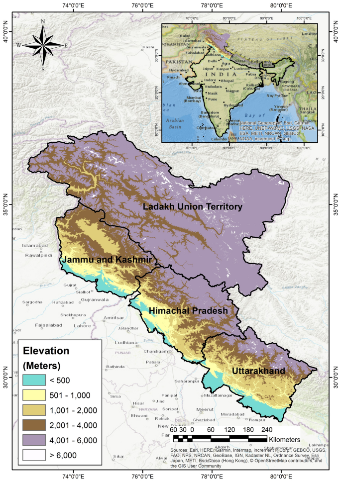
The state’s diverse topography is part of the Himalayan system, with elevations ranging from 350 meters to 7,000 meters above sea level. It can be divided into three distinct physiographic zones from south to north:
The Siwaliks (Outer Himalayas)
- Location: Lower hills of Kangra, Hamirpur, Una, Bilaspur, and the lower parts of Mandi, Solan, and Sirmaur districts.
- Altitude: 350 to 1,500 meters above sea level
- Rainfall: 1,500 mm to 1,800 mm annually
- Characteristics: Made up of consolidated deposits prone to erosion, leading to deforestation and high soil erosion rates.

Inner Himalayas (Mid-Mountains)
- Location: Upper parts of Pachhad and Renuka in Sirmaur district, Chachiot and Karsog tehsil of Chamba district.
- Altitude: 1,500 to 4,500 meters above sea level
- Soil: Ranges from silty loam to clay loam to dark brown in color.
Alpine Zone (Greater Himalayas)
- Location: Comprises Kinnaur district, Pangi tehsil of Chamba district, and some areas of Lahaul and Spiti.
- Altitude: Above 4,500 meters above sea level
The state is home to five major perennial rivers:
- Sutlej
- Beas
- Ravi
- Chenab
- Yamuna
While these rivers are vital to the Indus river basin, their utility for irrigation is limited due to the undulating terrain of the Himalayas.
Major Perennial Rivers of Himachal Pradesh
Himachal Pradesh, renowned for its mountainous terrain, is home to several major perennial rivers. These rivers are crucial for the state’s agriculture, hydropower generation, and overall water supply. Here is a detailed look at each of the major perennial rivers:
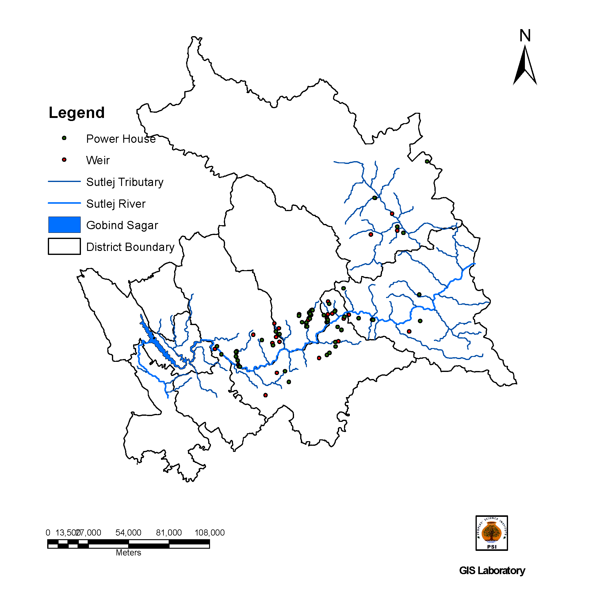
1. Sutlej River
- Origin: The Sutlej River originates from Lake Rakshastal in Tibet, near Mansarovar Lake.
- Course in Himachal Pradesh: It enters Himachal Pradesh near the Shipki La Pass in the Kinnaur district and flows southwestward. The river passes through the districts of Kinnaur, Shimla, and Solan, eventually forming the boundary between Himachal Pradesh and Punjab.
- Significance: The Sutlej is vital for irrigation and hydropower projects, including the Bhakra-Nangal Dam. It also feeds the Beas-Sutlej Link Canal, which is crucial for agriculture in the region.
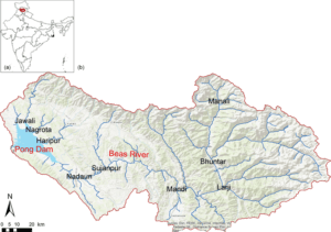
2. Beas River
- Origin: The Beas River originates from the Beas Kund, located in the Pir Panjal range of the Western Himalayas.
- Course in Himachal Pradesh: It flows through the Kullu Valley, moving southward through the districts of Kullu, Mandi, and Bilaspur before entering Punjab. It eventually merges with the Chenab River in Pakistan.
- Significance: The Beas is essential for agriculture and hydropower, contributing to projects like the Pandoh Dam and the Beas-Sutlej Link Canal. It also supports diverse ecosystems and wildlife.
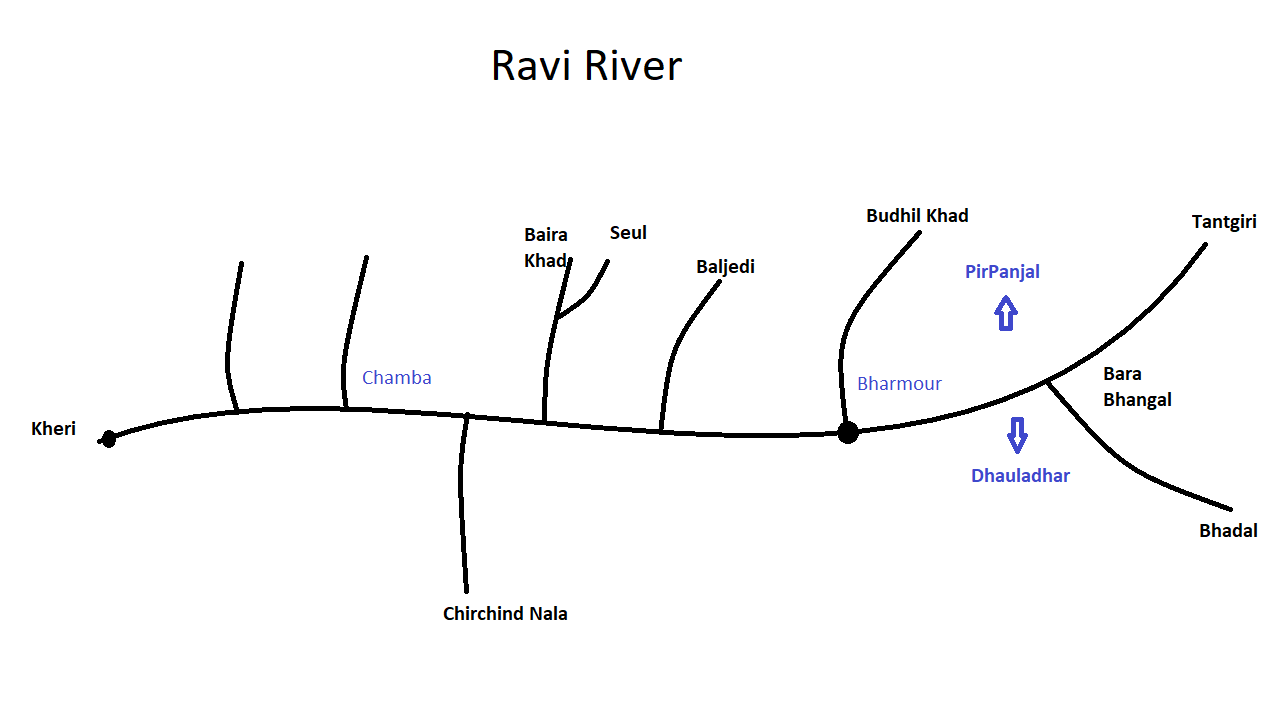
3. Ravi River
- Origin: The Ravi River originates in the Multhan Tehsil of Kangra district, Himachal Pradesh, from glaciers in the Rohtang Pass, fed by the Bhadal and Tantgari streams.
- Course in Himachal Pradesh: It flows through the Barabhangal, Bara Bansu, and Chamba districts. The river exits Himachal Pradesh at Madhopur in the Pathankot district of Punjab.
- Significance: The Ravi is a transboundary river that flows into Pakistan, where it joins the Chenab River. It is part of the Indus River Basin, critical for irrigation and agriculture in both countries. Historically, it was known as Purushni or Iravati in Vedic times and Hydraotes to the Ancient Greeks.
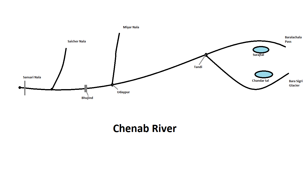
4. Chenab River
- Origin: The Chenab River is formed by the confluence of the Chandra and Bhaga rivers, which originate in the Lahaul-Spiti district of Himachal Pradesh.
- Course in Himachal Pradesh: It flows southeast from its source, passing through the Lahaul and Spiti districts, and then into the Chamba district. The river crosses into Pakistan, where it merges with the Jhelum and Ravi rivers.
- Significance: The Chenab is essential for agriculture and water resources in both Himachal Pradesh and Pakistan. It supports various irrigation projects and contributes significantly to the Indus Basin irrigation system.
5. Yamuna River
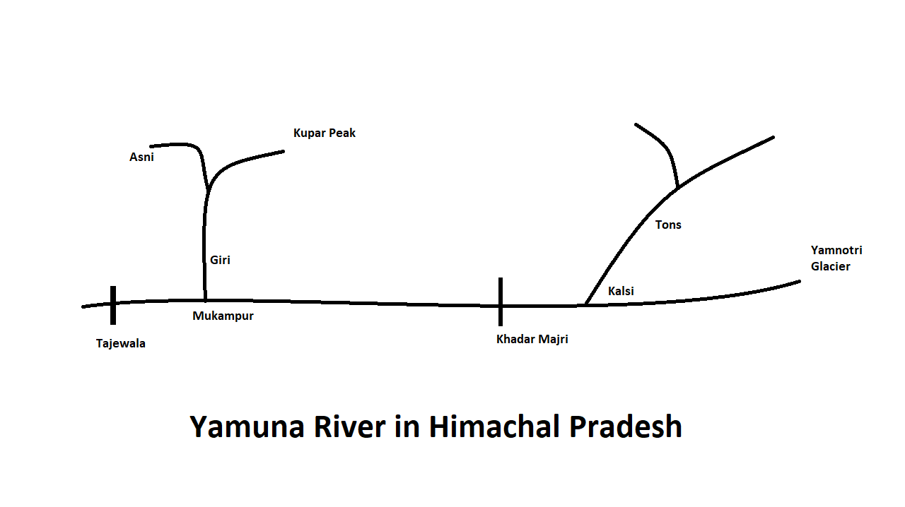
- Origin: The Yamuna River originates from the Yamunotri Glacier in the Uttarkashi district of Uttarakhand, but flows into Himachal Pradesh through the Shivalik Hills.
- Course in Himachal Pradesh: It flows through the Sirmaur district before moving into Haryana. The river is a major tributary of the Ganges.
- Significance: The Yamuna is crucial for drinking water supply, agriculture, and maintaining ecological balance in the region. It also holds significant cultural and religious importance.
Importance of These Rivers
- Hydropower Generation: Rivers like the Sutlej, Beas, and Chenab are harnessed for hydropower, contributing to the energy needs of Himachal Pradesh and neighboring regions.
- Irrigation: These rivers provide essential water resources for agriculture, supporting crop production and food security.
- Cultural and Ecological Significance: Each river has historical, cultural, and ecological importance, influencing local communities and ecosystems.
Overall, the perennial rivers of Himachal Pradesh are integral to the state’s economy, environment, and cultural heritage, shaping the landscape and sustaining life across the region.
Languages Spoken: The major languages spoken in Himachal Pradesh include:
- Hindi
- Punjabi
- Mahasui
- Kulluyi
- Lahauli
- Kinnauri
- Chambyali
- Sirmauri
- Gojri (by Gujjars)
- Bilaspuri
- Pahari
- Dogri
- Kangri
 “
“
Through the provided image, you can understand the geographical division of Himachal Pradesh.”
- गीला उप-समशीतोष्ण क्षेत्र (Wet Sub-temperate Zone)
- विवरण:
- इस क्षेत्र में भारी वर्षा होती है और यह समशीतोष्ण वनस्पति के लिए उपयुक्त है।
- स्थान:
- कांगड़ा जिले के पालमपुर और धर्मशाला
- मंडी जिले का जोगिंदरनगर क्षेत्र
- चंबा जिले का डलहौजी क्षेत्र
- आर्द्र उप-समशीतोष्ण क्षेत्र (Humid Sub-temperate Zone)
- विवरण:
- इस क्षेत्र में मौसम अधिक आर्द्र होता है और यहाँ की वनस्पति भी समशीतोष्ण होती है।
- स्थान:
- कुल्लू
- शिमला
- मंडी के कुछ हिस्से
- सोलन
- चंबा
- कांगड़ा
- सिरमौर
- सूखा समशीतोष्ण-आल्पाइन ऊँचाई क्षेत्र (Dry Temperate-Alpine Highlands)
- विवरण:
- इस क्षेत्र में सूखा मौसम और ऊँचाई पर स्थित आल्पाइन वनस्पति होती है।
- स्थान:
- लाहौल-स्पीति
- पांगी
- किन्नौर
- आर्द्र उप-उष्णकटिबंधीय क्षेत्र (Humid Sub-tropical Zone)
- विवरण:
- इस क्षेत्र में उष्णकटिबंधीय मौसम और आर्द्रता होती है।
- स्थान:
- सिरमौर जिला
- चंबा जिले की भटियात घाटी
- सोलन जिले का नालागढ़ क्षेत्र
- कांगड़ा जिले के देहरागोपीपुर और नूरपुर क्षेत्र
- उप-आर्द्र उष्णकटिबंधीय क्षेत्र (Sub-Humid Tropical Zone)
- विवरण:
- इस क्षेत्र में मौसम अपेक्षाकृत आर्द्र होता है, लेकिन पूरी तरह से उष्णकटिबंधीय नहीं है।
- स्थान:
- सिरमौर
- कांगड़ा जिले का इंदोरा क्षेत्र
 “Through the provided image, you can understand the geographical division of Himachal Pradesh and their elevations.”
इन क्षेत्रों की भौगोलिक विशेषताएँ हिमाचल प्रदेश की जलवायु, वनस्पति और भूगर्भीय संरचना को निर्धारित करती हैं।
Q1. What is the highest peak in the Shiwalik range?
A. Churdhar
B. Hanuman Ji Ka Tibba
C. Shilla Peak
D. Nagru
Answer: A. Churdhar
Explanation: Churdhar or Choor Chandni, standing at 3,647 meters, is the highest peak in the Shiwalik range, which spans parts of districts like Sirmaur and Bilaspur.
Q2. Which physiographic zone of Himachal Pradesh is characterized by heavy rainfall and temperate vegetation?
A. Dry Temperate-Alpine Highlands
B. Wet Sub-temperate Zone
C. Humid Sub-tropical Zone
D. Sub-humid Tropical Zone
Answer: B. Wet Sub-temperate Zone
Explanation: The Wet Sub-temperate Zone receives heavy rainfall and supports temperate vegetation, including areas like Palampur and Dharamsala.
Q3. Which range is known as the ‘White Range’ in Himachal Pradesh?
A. Pir Panjal
B. Dhauladhar
C. Zanskar
D. Shiwalik
Answer: B. Dhauladhar
Explanation: The Dhauladhar Range, known as the ‘White Range,’ has an average elevation of 4,550 meters and is noted for its snow-capped peaks.
Q4. In which zone would you find areas like Lahaul-Spiti and Kinnaur?
A. Humid Sub-temperate Zone
B. Wet Sub-temperate Zone
C. Dry Temperate-Alpine Highlands
D. Sub-humid Tropical Zone
Answer: C. Dry Temperate-Alpine Highlands
Explanation: The Dry Temperate-Alpine Highlands include regions such as Lahaul-Spiti and Kinnaur, characterized by a dry climate and alpine vegetation.
Q5. Which zone is primarily covered by sandy loams and experiences a dry climate?
A. Wet Sub-temperate Zone
B. Dry Temperate-Alpine Highlands
C. Humid Sub-tropical Zone
D. Sub-humid Tropical Zone
Answer: B. Dry Temperate-Alpine Highlands
Explanation: The Dry Temperate-Alpine Highlands are characterized by sandy loams and a dry climate, with areas like Pangi and Lahaul-Spiti.
Q6. Which range forms a water divide between the Chenab river and the Beas and Ravi rivers?
A. Dhauladhar
B. Pir Panjal
C. Zanskar
D. Shiwalik
Answer: B. Pir Panjal
Explanation: The Pir Panjal Range serves as a water divide, separating the Chenab river from the Beas and Ravi rivers, and influences the drainage patterns in the region.
Q7. What is the average elevation of the Great Himalayas or Himadri range?
A. 3,000 to 5,000 meters
B. 4,000 to 6,000 meters
C. 5,000 to 7,000 meters
D. 6,000 to 8,000 meters
Answer: C. 5,000 to 7,000 meters
Explanation: The Great Himalayas, also known as Himadri, have an average elevation ranging from 5,000 to 7,000 meters above sea level.
Q8. Which district contains the highest peak of the Pir Panjal Range?
A. Kullu
B. Chamba
C. Mandi
D. Shimla
Answer: B. Chamba
Explanation: The Pir Panjal Range, with its major expansion in Chamba district, includes some of the highest peaks of the range, like the famous Rohtang Pass.
Q9. Which of the following areas is in the Wet Sub-temperate Zone?
A. Bhattiyat Valley
B. Nalagarh
C. Dharamsala
D. Dehragopipur
Answer: C. Dharamsala
Explanation: Dharamsala, located in the Wet Sub-temperate Zone, is known for its heavy rainfall and temperate vegetation.
Q10. What is the primary vegetation found in the Humid Sub-temperate Zone?
A. Desert flora
B. Tropical rainforest
C. Temperate vegetation
D. Alpine flora
Answer: C. Temperate vegetation
Explanation: The Humid Sub-temperate Zone supports temperate vegetation due to its humid conditions, covering areas like Kullu and Shimla.
Q11. Which area is known for its dry climate and alpine vegetation?
A. Sirmaur
B. Kullu
C. Lahaul-Spiti
D. Shimla
Answer: C. Lahaul-Spiti
Explanation: Lahaul-Spiti is known for its dry climate and alpine vegetation, fitting into the Dry Temperate-Alpine Highlands zone.
Q12. What type of soil is commonly found in the Dry Temperate-Alpine Highlands?
A. Sandy loams
B. Clay loams
C. Silt loams
D. Loamy sand
Answer: A. Sandy loams
Explanation: The Dry Temperate-Alpine Highlands predominantly feature sandy loams, contributing to the dry climate and sparse vegetation.
Q13. Which physiographic zone is characterized by significant humidity and tropical climate?
A. Humid Sub-tropical Zone
B. Wet Sub-temperate Zone
C. Sub-humid Tropical Zone
D. Dry Temperate-Alpine Highlands
Answer: A. Humid Sub-tropical Zone
Explanation: The Humid Sub-tropical Zone has a tropical climate with significant humidity, covering areas like Sirmaur and Bhattiyat Valley.
Q14. The Zanskar Range primarily separates which regions?
A. Kinnaur and Tibet
B. Spiti and Lahaul
C. Kinnaur and Spiti
D. Lahaul and Kashmir
Answer: C. Kinnaur and Spiti
Explanation: The Zanskar Range separates Kinnaur and Spiti from Tibet, Kashmir, and Ladakh, with Shilla Peak as a notable feature.
Q15. Which area is known for the formation of gullies due to erosion?
A. Kullu
B. Chamba
C. Una
D. Shimla
Answer: C. Una
Explanation: The Una district is known for the formation of gullies or “chos” due to erosion and deforestation in the Shiwalik range.
Q16. Which mountain range in Himachal Pradesh is known for its volcanic rocks?
A. Dhauladhar
B. Pir Panjal
C. Zanskar
D. Shiwalik
Answer: B. Pir Panjal
Explanation: The Pir Panjal Range, part of the inner Himalayas, is notable for its volcanic rocks and serves as a significant geological feature in the region.
Q17. Which area in the Sub-humid Tropical Zone is noted for having relatively humid conditions?
A. Nalagarh
B. Bhattiyat Valley
C. Indora
D. Dharamsala
Answer: C. Indora
Explanation: The Sub-humid Tropical Zone includes areas like Indora, where the conditions are relatively humid but not fully tropical.
Q18. Which range extends from Uttarakhand and is intercepted by multiple rivers in Himachal Pradesh?
A. Shiwalik
B. Zanskar
C. Dhauladhar
D. Pir Panjal
Answer: C. Dhauladhar
Explanation: The Dhauladhar Range extends from Uttarakhand and is intercepted by rivers like the Sutlej, Beas, and Ravi in Himachal Pradesh.
Q19. Which physiographic zone is characterized by an average elevation of 3,000 meters and deep gorges formed by the Sutlej river?
A. Great Himalayas
B. Zanskar Range
C. Dhauladhar Range
D. Pir Panjal Range
Answer: B. Zanskar Range
Explanation: The Zanskar Range, with an average elevation of 3,000 meters, features deep gorges formed by the Sutlej river and separates Kinnaur and Spiti.
Q20. What type of soil is typical in the Humid Sub-temperate Zone?
A. Sandy loams
B. Silt loams
C. Clay loams
D. Loamy sand
Answer: B. Silt loams
Explanation: The Humid Sub-temperate Zone typically features silt loams, which are suitable for growing a variety of temperate crops in regions like Shimla and Kullu.
Here’s the clickable list for easy access: